Stutsman County Approves $35 Per-Acre Cut in Farmland Assessments
Stutsman County commissioners approved an average 4% cut to farmland assessments, lowering the county per-acre assessed value by $35 and trimming the local tax base.

Stutsman County commissioners approved an average reduction of about 4% in the values used to assess agricultural property, cutting the county’s average per-acre assessed value from roughly $786 to $751. The move, approved by the commission on Tuesday, Feb. 3, will remove just over $2 million from the county’s taxable base and slightly reduce agriculture’s share of overall taxable value.
Tyler Perleberg, Stutsman County director of tax equalization, provided the figures and framed the impact for local taxpayers. “Last year, 33% of all taxable value in Stutsman County was ag land,” Perleberg said. “After this adjustment, it will be between 31% and 32% this year.” For landowners and township officials, that shift matters: lower assessed values reduce individual property tax bills if levy rates stay constant, but the change also forces local governments to finalize budgets with a smaller taxable base.
Perleberg pointed to local geography and soil differences as reasons Stutsman’s per-acre assessments sit where they do. “The Red River Valley counties all have higher farmland values due to better soils,” he said. “Stutsman County values are lower because of the hilly land in the western part of the county and the inundated acres of the Prairie Pothole Region.” State rules recognize inundated acres as a distinct class: in 1999 the Legislature created an inundated-land category, and those acres are valued at 10 percent of the non-cropland value for the county.
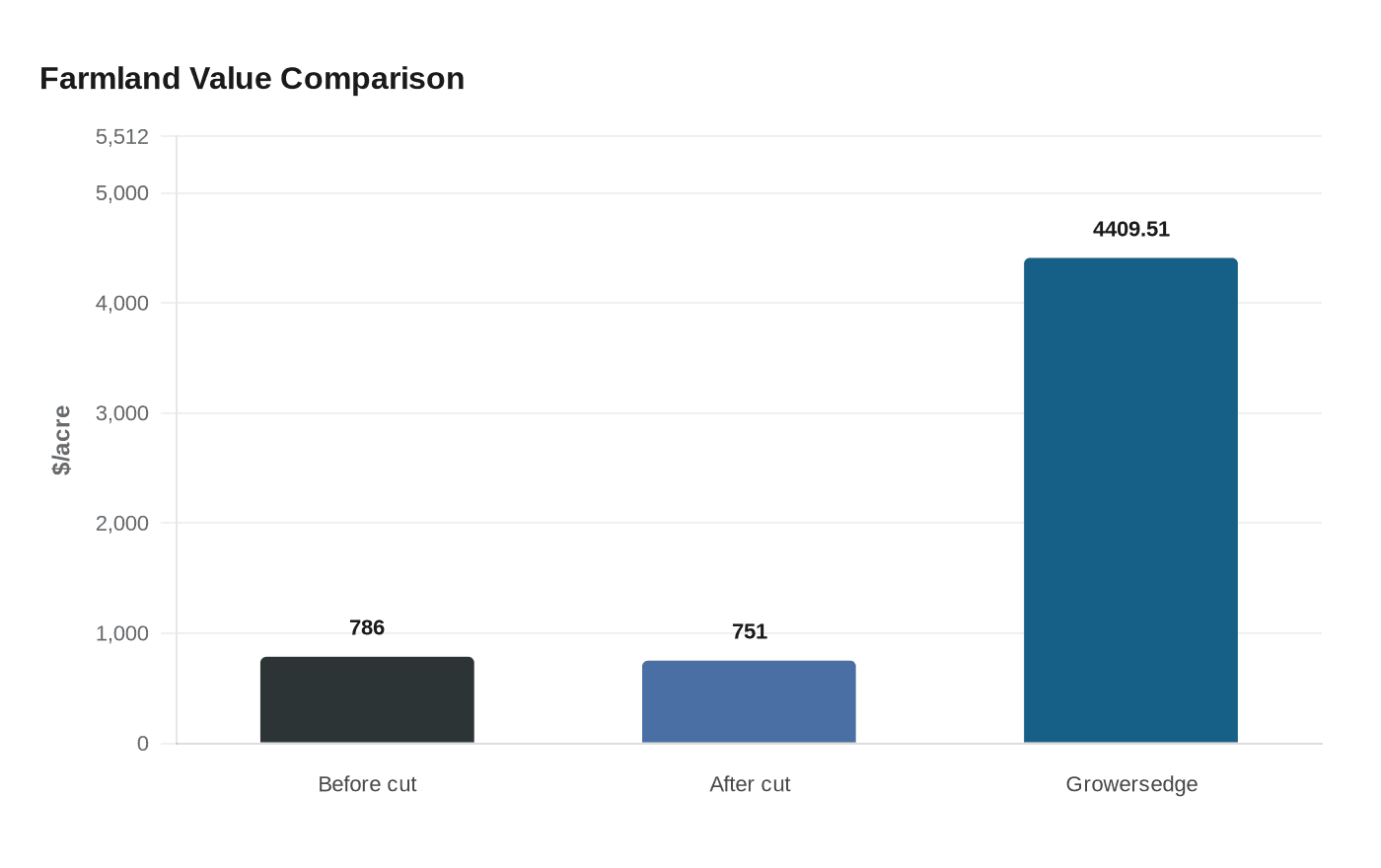
The assessor’s adjustment sits alongside several other measures and indexes that use different methods and produce very different per-acre numbers. A private index shows much higher market-oriented values: Growersedge lists Stutsman County at $4,409.51 per acre in its Q4 2024 “Value / Acre” table, while Growersedge commentary warns that “Entering 2025, high interest rates and low commodity prices are wearing on farmers’ overall economic wellbeing, though high demand for land is offering at least some resistance to those forces.”
Academic and state-model sources further complicate comparisons. Ageconsearch and University of Minnesota materials note that “The North Dakota Land Valuation Model was designed to estimate the value of agricultural land depending solely on the revenue generated from the production of crops and beef cattle. The results of this model were not intended to reflect market value.” Ageconsearch excerpts also include multiple county data lines for Stutsman, for example: "Stutsman 1,065.80 212.03 827.27", "Stutsman 1,194.91 187.27 1,050.39", and "Stutsman 990.05 208.10 771.59". State library tables include the row "Stutsman 275,000 43,300 318,300 0.75 0.80 20,185,481 3,390,182 23,575,663" and another excerpt shows "Stutsman 699.33 164.68 551.01."
Practically, property owners will see notices of assessed value mailed in March. Property owners may protest valuations in April at a date to be set. Final tax calculations come after local budgeting for cities, townships, schools and other governments; tax statements will be mailed in December and payment is due by March 2027.
For Stutsman County farmers, landowners and local officials the cut is modest but meaningful: it buffers some near-term tax pressure for agricultural property owners while tightening the revenue picture for local budgets. The coming weeks of notices and the April protest window will be the first chance for landowners to review individual parcel calculations and, if needed, seek adjustments.
This article was produced by Prism’s automated news system from verified source data, official records, and press releases, then run through automated quality and moderation checks before publishing. The system is built and supervised by the people who set the standards it runs under. Read our full AI policy.
Did this article answer your question?