Sunapee to test temporary Route 11 redesign for safer crossings
Sunapee will turn Route 11 near Lower Main Street into a nine-day street test with protected crossings, median posts and temporary parking markings.
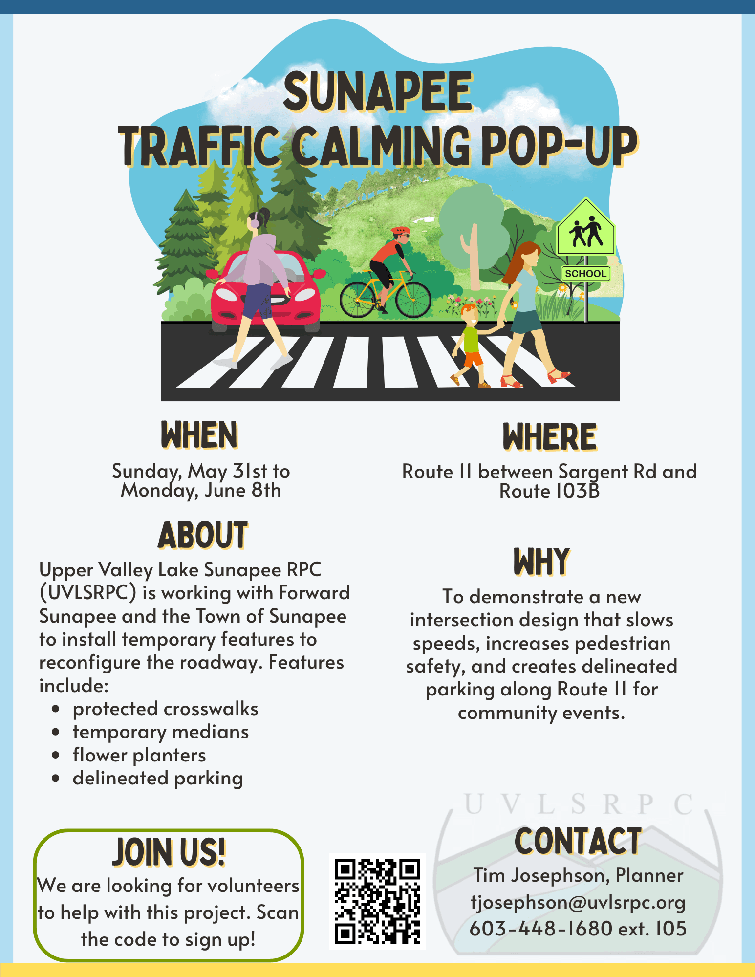
Sunapee will test a temporary traffic-calming redesign on Route 11 near Lower Main Street from Sunday, May 31, through Monday, June 8, with re-striped and protected crosswalks, median traffic posts, delineated parking and temporary markings for possible parking and public-use space.
The short-term setup is meant to slow traffic and make the corridor easier to cross on foot, while also giving residents a chance to see how a calmer street feels in real use. Sunapee said the demonstration is not a final plan. Any permanent change would still need full engineering design, review and approval from the New Hampshire Department of Transportation.
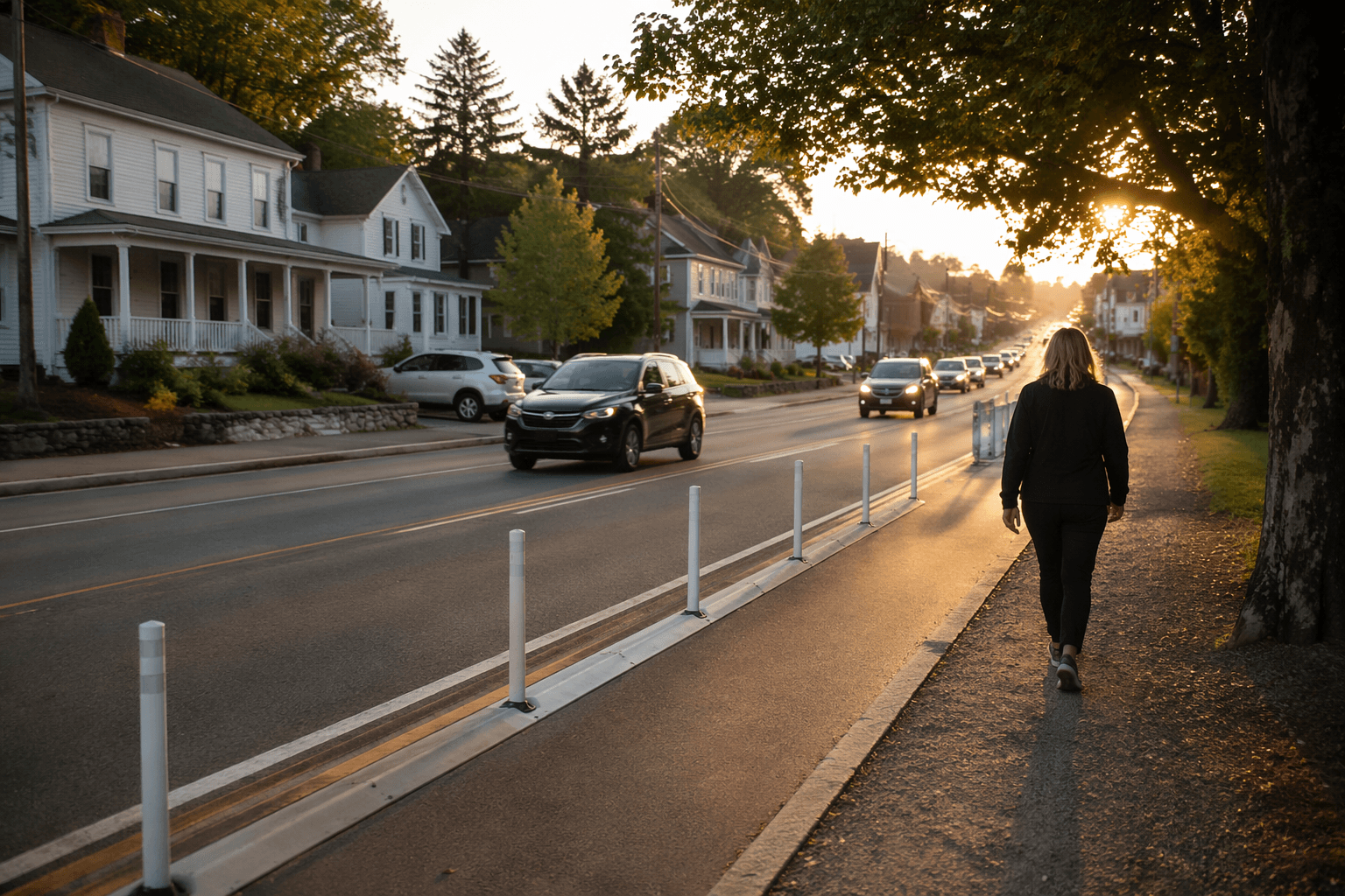
The town is framing the pop-up as both a safety measure and a policy test. Motorists traveling Route 11 should expect a visibly different street edge, narrower-looking travel space and new visual cues around where to drive and where to stop. Pedestrians will see the most immediate change, with more defined crossings and a street layout intended to make Lower Main Street feel more walkable and inviting. Nearby businesses could also see a shift in how people move through the area as the town experiments with parking placement, public-use space and landscaping-style touches such as flowers.
Sunapee and its partners are asking residents to drive, walk and bike through the area during the demonstration, then weigh in based on what they experience. Volunteers will be needed to help set up, monitor and later break down the temporary installation, a sign that the project is meant to be hands-on and community-driven rather than purely advisory.
The pop-up is the latest step in a longer Route 11 connectivity effort led by Forward Sunapee’s Route 11 Connectivity Committee. The committee’s mission covers Route 11 from Sargent Road to 103B, with priorities that include safety, accessibility, connectivity, traffic calming, landscaping, additional parking, sidewalks, identifiable walking and biking lanes, median strips, accessible parking, and a path linking Abbott Library and Lower Main. The group has been meeting monthly, has met with the Upper Valley Lake Sunapee Regional Planning Commission and state transportation officials, and has discussed Transportation Alternatives Program funding.
At a December 17, 2024 meeting, committee members said Route 11 has wide lanes and a lack of visual cues. They also noted that the state owns about 150 feet side to side of the roadway and discussed standards calling for a 12-foot travel lane with a 4-foot shoulder, or 32 feet minimum overall. Plans in the state right of way would require review and approval by NHDOT District 2 Engineer Chris Turgeon.
The push grew out of Sunapee’s April 12 and 13, 2024 community design charrette with Plan NH, town officials, engineers, planners and local groups. The town’s Highway Department, which maintains and improves highways, sidewalks, stormwater systems, bridges, dams and intersection signalization, will be part of the broader infrastructure work if the concept moves past the pop-up stage.
This article was produced by Prism’s automated news system from verified source data, official records, and press releases, then run through automated quality and moderation checks before publishing. The system is built and supervised by the people who set the standards it runs under. Read our full AI policy.
Did this article answer your question?