How Amistad Reservoir works as a binational border lake
Amistad is not just a lake; it is a border system with two sets of rules, shifting access, and consequences for Del Rio boaters.
The water between Del Rio and Ciudad Acuña sits under binational management. The International Boundary and Water Commission operates Amistad Dam, and the National Park Service manages the U.S. side as Amistad National Recreation Area. In Val Verde County, reservoir levels, fishing rules, launch access, and enforcement change depending on which side of the boundary you are on.
A lake built for two countries
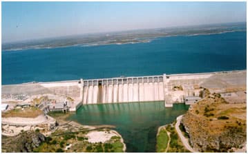
Amistad Dam was dedicated on September 8, 1969, by U.S. President Richard M. Nixon and Mexico President Díaz Ordaz. It is the second international storage dam built jointly by the United States and Mexico under the 1944 Water Treaty, and the IBWC lists it as the largest of the storage dams and reservoirs on the international reach of the Rio Grande. The U.S. side of the reservoir was transferred to the National Park Service in 1990 when Congress designated Amistad National Recreation Area.
At conservation pool level, Amistad holds about 65,000 surface acres and 3,159,270 acre-feet of water, with 851 miles of shoreline. Of that shoreline, 547 miles lie on the United States side and 304 miles on the Mexico side. Amistad National Recreation Area covers 57,292 acres in all, including 17,820 land acres at conservation pool level.
Who controls what on the water
The border runs through the reservoir itself, and the line is marked by buoys numbered RG1 through RG28. It determines which rules apply where, which fishing license you need, and which boating laws govern your trip. On the U.S. side, Texas fishing license rules apply, all Texas boating rules apply, and the National Park Service and Texas Parks & Wildlife Department manage access and enforcement. On the Mexico side, a Mexican fishing license is required.

If you are planning to cross near the dam or move between sides, the practical rule is simple: know which country you are in before you launch, cast, or fish a shoreline.
What low water changes for Del Rio
Amistad sits in a desert basin, and that makes its level vulnerable to drought and rainfall patterns across both Texas and Mexico. National Park Service records show the reservoir reached its second historic low on May 23, 2013, when the water fell to 1,055.93 feet above mean sea level, 61.07 feet below full level. At those low levels, hazardous rocks were exposed and many boat ramps became unusable.
Lower water can mean longer walks from a trailer to the edge of the lake, fewer safe launch sites, more exposed submerged hazards, and tighter pressure on the ramps that remain usable. The park and state agencies list specific launch points, but access changes with the water, so local conditions can shift from one season to the next.
What anglers and boaters need to carry
For people using the lake, the rules are practical and immediate. Motorized craft need a lake use pass, and boaters are expected to clean, drain, and dry gear to avoid spreading invasive mussels. The lake has become part of Texas’s wider fight against zebra and quagga mussels.

Texas Parks & Wildlife recorded the first Texas detection of quagga mussels in Lake Amistad in 2021. Texas Parks & Wildlife detected zebra mussels at several sites in February 2024 and warned that record low water helped expose submerged rocks and reveal the infestation. For local anglers, that means every trailer, livewell, rope, and anchor can become part of the enforcement and prevention picture if it moves water from one lake to another.
- Motorized boats need a lake use pass.
- Clean, drain, and dry all equipment before moving to another waterbody.
- Use the correct fishing license for the side of the border you are on.
- Check launch access before heading out, because low water can close or limit ramps.
Why the lake matters beyond recreation
Amistad National Recreation Area is one of the region’s most unusual public lands because it combines water access, desert scenery, and deep cultural history. The park’s cultural history stretches back nearly 5,000 years, and its pictographs are about 4,000 years old. Two major public pictograph sites, Panther Cave and Parida Cave, are part of that record and make the lake corridor more than a boating destination.
People come for boating, camping, birding, swimming, and rock art access. The lake is one piece of a larger border-water system that the IBWC monitors alongside Falcon and Elephant Butte/Caballo.
This article was produced by Prism’s automated news system from verified source data, official records, and press releases, then run through automated quality and moderation checks before publishing. The system is built and supervised by the people who set the standards it runs under. Read our full AI policy.
Did this article answer your question?