Tomé Land Grant documents restored, preserving 1860 boundaries
Fragile Tomé Land Grant papers once sealed in a metal tube now preserve 1860 boundaries, ownership history, and evidence future disputes may depend on.

A set of Tomé Land Grant papers that could have faded into illegibility now stands as readable evidence of where the community’s 1860 boundaries ran. Restored with help from the Center for Southwest Research at the University of New Mexico, the map and patent are no longer just heirlooms tucked away in a tube. They are a usable public record for descendants, property owners, historians, and local schools.
How the records were rescued
Andrea Padilla, president of the Town of Tomé Land Grant, brought the original metal tube to the Center for Southwest Research in December 2021. The documents inside had been stored for generations, but age had made them fragile and difficult to read, which meant the evidence they carried about boundaries, ownership, and lineage was in danger of being lost.
Jennifer Dawn Eggleston, the conservation technician, flattened and encapsulated the aging map and related documentation in about a week. Jeanette Alvarez, the scanning technician, and Samuel Sisneros, the head archivist, worked on the project as well, helping improve the document’s coloration so the details could be studied more easily.
The original map and patent can now be viewed at the Town of Tomé Land Grant Museum and Library, giving the community a preserved reference point for one of the most important documents in its history.
What the map actually proves
The restored map marks the corner stones and earth mounds along the northern Thome Dominguez line and the three cottonwood trees at the Belen Grant line, details that help anchor the grant in specific ground features rather than vague memory.
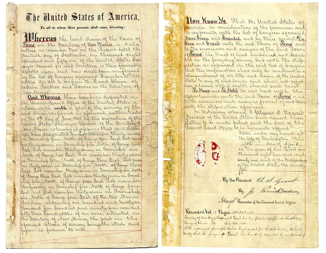
The patent tied to the grant carries its own legal weight. The document was signed by U.S. President Ulysses S. Grant in July 1871, then registered in Valencia County in 1871 and again in 1913. Together, the 1860 boundary materials and the later patent create a paper trail that links local land use to the federal government’s formal recognition of the grant.
A cleaned, digitized, and stabilized record is easier to study, compare, and preserve than a brittle original sealed in an old tube. It gives the town a reliable reference if questions ever arise over where the historic boundaries ran or how later claims should be understood.
Why Tomé’s land history is bigger than one community
Tomé’s roots reach back to 1739, when a Spanish royal grant and, later, the community itself became part of the Rio Abajo’s complex land history. The town was founded in 1739 by 29 genízaro families from the Albuquerque area, according to a New Mexico Legislature handout. The original grant covered 189,350 acres, a footprint that once made Tomé a much larger landholding community than it is today.
Tomé lost 50,000 acres to the Forest Service in 1856, another 92,350 acres because of taxes in 1907, and the last 47,000 acres were sold in 1968, according to the same handout. By then, the community was left with no remaining land.
The United States was supposed to honor land-grant agreements under the Treaty of Guadalupe Hidalgo, the compact that ended the U.S.-Mexico War and required the United States to respect existing property rights. In New Mexico, that obligation collided with a difficult confirmation system. State records show the Surveyor General considered about 180 non-Pueblo claims and confirmed 46, while the later Court of Private Land Claims considered 282 New Mexico claims and confirmed 82.
A local archive with legal and cultural weight
Padilla has described Tomé Hill as sacred to Native Americans and to the community. For families with ties to the grant, the map is not just a historical artifact. It is a record that helps explain inheritance, boundaries, and the long changes in sovereignty from Spain to Mexico to the United States.
Descendants can trace place names and boundary markers. Property owners can compare historic lines with modern assumptions. Historians can study how Tomé’s paper record fits into the broader New Mexico land-grant story. Schools can use the materials to show how legal history lives in local places, not only in state archives and courtrooms.
The restoration also shifts the documents from private fragility to public access. What once risked being unreadable inside a metal tube is now an archive that can be handled carefully, studied repeatedly, and passed forward without sacrificing the originals.
This article was produced by Prism’s automated news system from verified source data, official records, and press releases, then run through automated quality and moderation checks before publishing. The system is built and supervised by the people who set the standards it runs under. Read our full AI policy.
Did this article answer your question?