Vinton County place names reveal clues to its 19th-century past
Vinton County’s road names and townships still map its 1850 birth, from elk country and rich land to presidents, mills, and family names locals still know.
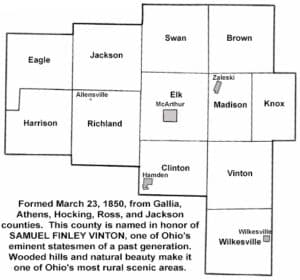
Every sign that says Brown, Elk, Richland, or Wilkesville carries a piece of Vinton County’s first settlement story. The county itself was carved out on March 23, 1850, from parts of Gallia, Athens, Hocking, Ross, and Jackson counties, then named for Samuel Finley Vinton, the Gallia County congressman and attorney whose name became Ohio’s 82nd county.
A county created from five neighbors
That 1850 boundary line matters because it explains why so many Vinton County place names feel like a memory bank. The county’s official history places Samuel Finley Vinton at the center of that origin story, not as a distant politician, but as a local lawyer who argued cases before circuit judges in the county seat and practiced across the surrounding counties. The result was a new county with a name tied to state politics, but a landscape whose smaller township and community names preserved older, more local clues.
Vinton County remains one of Ohio’s smallest counties in both population and scale. The U.S. Census Bureau counted 12,800 residents in the 2020 Census and estimated 12,645 on July 1, 2025. The county covers 412.4 square miles of land area, a size that helps explain why familiar names still carry such weight in everyday directions and family memory.
Township names that preserve political memory
Some of the township names read like a lesson in 19th-century public life. Clinton honors George Clinton. Harrison, Jackson, and Madison honor presidents William Henry Harrison, Andrew Jackson, and James Madison. Knox reaches back further to Revolutionary War general Henry Knox. Vinton repeats the county’s own namesake, keeping the same political lineage visible in both the county and one of its townships.
Brown Township stands out for a different reason. Local history says it was named for Brown, described as the most common surname in the United States at the time. That detail suggests something practical and familiar rather than heroic or ceremonial: a name rooted in the ordinary people who filled the county as it was being settled. Together, these township names show how local residents used politics, patriotism, and common identity to mark the land.
Wildlife, resources, and the shape of the land
Other names point straight to the landscape that early settlers encountered. Elk Township was named for the elk that once roamed the county, especially around Elk Fork Church, one mile north of McArthur. That one place name preserves the memory of a time when the county’s hills and forks were still shared with large game, long before modern roads fixed the map into its current shape.
Richland Township reveals another kind of early observation. Its name points to the rich and abundant natural resources in the area, a reminder that the land itself was part of the county’s identity long before settlement lines hardened into township borders. Even the bird name Swan fits that pattern, turning a living part of the local environment into a geographic marker that outlasted the original landscape.
Village names and the people who built them
The county’s smaller communities add another layer. Names such as Allensville, Arbaugh, Bolin’s Mills, Creola, Dundas, Eagle Mills, Elk Fork, Hawk or Hawks, Hue, and Wilkesville show how settlement history was recorded in everyday place names. In some cases, the names point to founders or local families. In others, they preserve mills, wildlife, or practical landmarks that mattered when travel was slower and a name had to do a lot of work.
Wilkesville is the clearest example in the county’s place-name history. It is linked to Captain Wilkes, an industrialist who lived in the township, showing how business and settlement could leave a mark as lasting as any public office. The mill names, meanwhile, hint at the economic life that once organized rural communities around timber, grain, and water power. These are the kinds of names that survive even when records grow thin, because people keep using them long after the original buildings or owners are gone.
Why these names still matter now
Vinton County’s modern identity makes the old names even more telling. The county sits in the Hocking Hills region and is home to the second largest state forest in Ohio, a setting that keeps land and landscape at the center of local life. In a county of 12,645 estimated residents spread across 412.4 square miles, the names on maps still help people recognize where they are, who came before them, and what kind of place this has always been.
That history also sits inside a larger Ohio story. Ohio History Connection says the state’s Indigenous history is a central part of Ohio’s overall history, a reminder that settlement names tell only one layer of the map. Vinton County’s township and community names preserve the 19th-century story of county building, but they sit within a deeper landscape that existed long before the county was formed.
Taken together, the names across Vinton County are more than labels for roads and crossroads. They preserve political loyalties, family memory, wildlife, resources, and the work of early communities that turned a stretch of southern Ohio into a county with a recognizable identity.
This article was produced by Prism’s automated news system from verified source data, official records, and press releases, then run through automated quality and moderation checks before publishing. The system is built and supervised by the people who set the standards it runs under. Read our full AI policy.
Did this article answer your question?