Late-day storms could bring damaging winds, hail to Wake County
Wake County faced a late-day storm window from about 4 p.m. to midnight, with wind gusts over 60 mph, isolated hail and a heat index near 107.
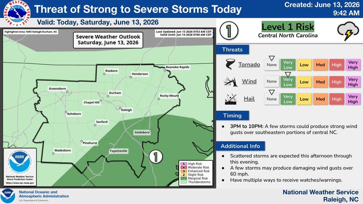
Storms were lining up for a late-day hit across Wake County, with the biggest severe-weather window running from about 4 p.m. to midnight. Forecasters said the main threat was damaging wind gusts over 60 mph, with isolated large hail also possible, while the Triangle north and east faced the highest risk.
The National Weather Service Raleigh had placed southeastern portions of central North Carolina under a Level 1, or Marginal, severe-storm risk, and the Storm Prediction Center expanded that to a Marginal risk across the broader region with a Slight risk from the Triangle north and east. That meant Wake County sat in a zone where isolated strong to severe storms were possible late today into tonight, even though widespread severe weather was not expected.
The timing mattered for daily life in Raleigh and across Wake County. The strongest storm potential was expected late in the afternoon through the evening, the same period when commutes, after-school pickup, youth sports, and outdoor events were most likely to be underway. Outside of storms, southwest winds could still gust to 20 to 30 mph, adding another layer of disruption for anyone on the road or outdoors.
Heat was making the situation more uncomfortable. A Heat Advisory was in effect for parts of central North Carolina, with highs in the mid 90s to low 100s and Wake County’s forecast calling for hot conditions, a chance of showers and thunderstorms in the afternoon and evening, and heat index values up to 107. NWS Raleigh said dangerously hot weather continued even as the storm threat built.
There was also a flooding concern. The Hazardous Weather Outlook carried a Marginal risk of excessive rainfall, and forecasters warned that if heavy rain held for more than an hour or two, localized flooding could develop, especially in urban areas. That raised the chance of brief problems on busy roads, in low-lying spots, and where drainage can be overwhelmed quickly.
For Wake County, the afternoon and evening were set up as a combined heat-and-storm day, with the most serious concerns centered on strong wind, hail, and short-fuse flooding from heavy downpours. The weather service said county-specific updates for Raleigh and the wider metro area remained the best way to track how the threat evolved.
This article was produced by Prism’s automated news system from verified source data, official records, and press releases, then run through automated quality and moderation checks before publishing. The system is built and supervised by the people who set the standards it runs under. Read our full AI policy.
Did this article answer your question?