Wake County faces heat advisory, fire danger and severe storm risk
Heat, fire danger and late-day storms hit Wake County as RDU could break a record high and heat indices climb to 103.
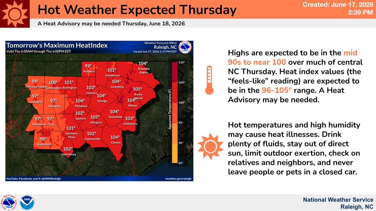
Wake County spent Thursday under a rare triple threat: dangerous heat, rising fire risk and the chance of severe storms by late day. National Weather Service Raleigh had a Heat Advisory in effect for the Triangle, eastern Piedmont, Sandhills and Coastal Plain from 11 a.m. to 8 p.m., with temperatures expected to reach the upper 90s to near 100 in much of central North Carolina and Raleigh-Durham International Airport likely to break its record high.
The disruption to daily life was immediate. Heat indices were expected to run from about 100 to 103 degrees, making outdoor work, errands and travel far harder than the thermometer alone suggested. Raleigh’s own guidance says extreme heat is one of the deadliest weather hazards in the United States, and the people most at risk include older adults, infants and young children, pregnant people, people with chronic conditions, outdoor workers and anyone without air conditioning.

Anyone who had to be outside needed to move fast and stay in the shade when possible. The city advised using air-conditioned spaces such as libraries, shopping malls and community centers, while Wake County said cooling centers were available during extreme heat events. That mattered most for people spending long hours on their feet, families without reliable cooling at home and anyone caring for pets, which needed water, shade and a break from hot pavement and parked cars.
The fire danger was high too. The weather service said increased fire risk was being driven by strong, gusty winds, hot temperatures and critically dry, drought-cured fuels. The Hazardous Weather Outlook said that fire danger was in effect from 10 a.m. through the afternoon, a warning that made any burning, dragging of trailer chains or spark-producing work especially risky across dry yards and field edges in Wake County and nearby counties.
Storm threats were building as the day went on. The outlook warned of isolated to scattered strong to severe storms capable of producing damaging straight-line winds Thursday afternoon and evening, with scattered storms possible overnight and some storms possibly becoming severe into early Friday. The weather service also flagged a risk of excessive rainfall Friday as a low-pressure system crossed the region, a setup that could turn quick downpours into localized flooding.
The day’s heat stood out even more against Raleigh’s climate normals. NOAA’s Raleigh climate data shows RDU’s late-June normal high is in the upper 80s to near 90, not near 100, underscoring how sharply Thursday pushed beyond what Wake County typically sees in mid-June.
This article was produced by Prism’s automated news system from verified source data, official records, and press releases, then run through automated quality and moderation checks before publishing. The system is built and supervised by the people who set the standards it runs under. Read our full AI policy.
Did this article answer your question?