Blood-Red Sky Over Shark Bay as Ex-Cyclone Narelle Drives Dust Storm
Narelle's 250 km/h gusts lofted iron-rich outback dust over Denham, turning Shark Bay's sky blood red in a rare triple-strike cyclone path not seen since 2005.
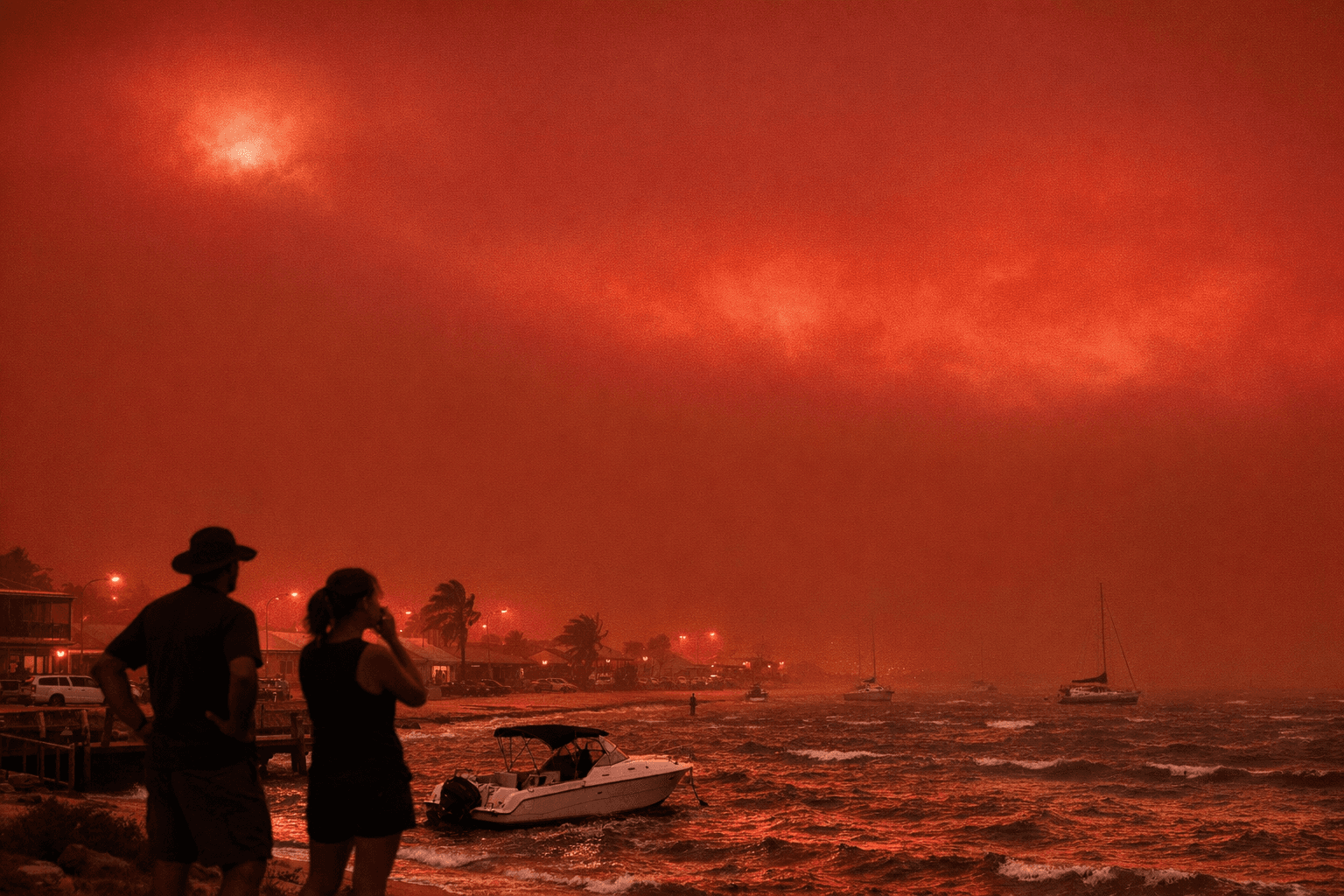
The sky over Denham turned the color of raw iron ore on Friday morning, and the Shark Bay Caravan Park posted the footage with two words: "No filter."
That footage, streamed live by the Shark Bay State Emergency Service and shared widely across social platforms, became one of the most striking visuals of what meteorologists confirmed was ex-tropical cyclone Narelle driving iron-rich outback dust high into the atmosphere over Western Australia's Shark Bay region. The spectacle was not a digital manipulation. It was physics: Narelle's winds lofted fine, iron-oxide-laden soil from the arid interior, and the sun's low-angle light scattered through the suspended particulate matter to produce a sustained, blood-red sky over Denham and surrounding coastal communities.
At its peak on March 26, Narelle carried sustained winds of 175 km/h near its centre, with gusts reaching 250 km/h, making it a severe Category 4 system. It made landfall just south of Coral Bay at approximately 9:30 a.m. on March 27, cutting a nearly 800-kilometre warning corridor stretching from Cape Preston south to Jurien Bay, encompassing Onslow, Carnarvon and Denham. Carnarvon faced projected gusts of up to 200 km/h; Denham, at the edge of the UNESCO World Heritage-listed Shark Bay, braced for gusts of 180 km/h.
The dust storm arrived ahead of the eye, reducing visibility in Denham to near zero and coating buildings and the coastline in a thick red film. More than 40 flights across Western Australia were cancelled or diverted on March 27 alone as the system grounded fly-in fly-out workforces and disrupted freight routes. Major LNG producers including Chevron and Woodside halted output after facilities in the cyclone's path sustained damage, with the Karratha gas plant among those affected.
Superintendent Bowen of Western Australia's emergency services urged residents not to underestimate the danger as the system moved through. "Please keep your plans in place and shelter indoors, because it is still a very large, significant system," he said. Emergency Services Minister Paul Papalia and Department of Fire and Emergency Services Commissioner Darren Klemm confirmed that the tourist town of Exmouth was the worst affected by the time the system had passed.
Narelle's path through Australia was historically rare. It made landfall in Queensland on March 20 before tracking through the Northern Territory and onto Western Australia, a triple-strike trajectory not recorded since Severe Cyclone Ingrid in 2005. The red sky it produced in Shark Bay was a direct consequence of that journey: thousands of kilometres of iron-rich, dry red soil lay in its path, available to be lofted and carried south into coastal communities.
Meteorologists note that such events carry consequences beyond the visual. Dust storms at this scale degrade air quality sharply, aggravating respiratory conditions and posing acute risks to people with asthma or cardiovascular disease. Maritime and aviation activity, both central to the economy of coastal Western Australia, grind to a halt under near-zero visibility conditions. As climate variability alters storm tracks and extends dry spells across Australia's interior, the supply of fine, mobilised dust available to future storm systems is unlikely to diminish.
Narelle was downgraded to a subtropical low by Saturday. The red sky has cleared, but the dust that settled across Shark Bay's beaches and towns will take considerably longer to disappear.
This article was produced by Prism’s automated news system from verified source data, official records, and press releases, then run through automated quality and moderation checks before publishing. The system is built and supervised by the people who set the standards it runs under. Read our full AI policy.
Did this article answer your question?