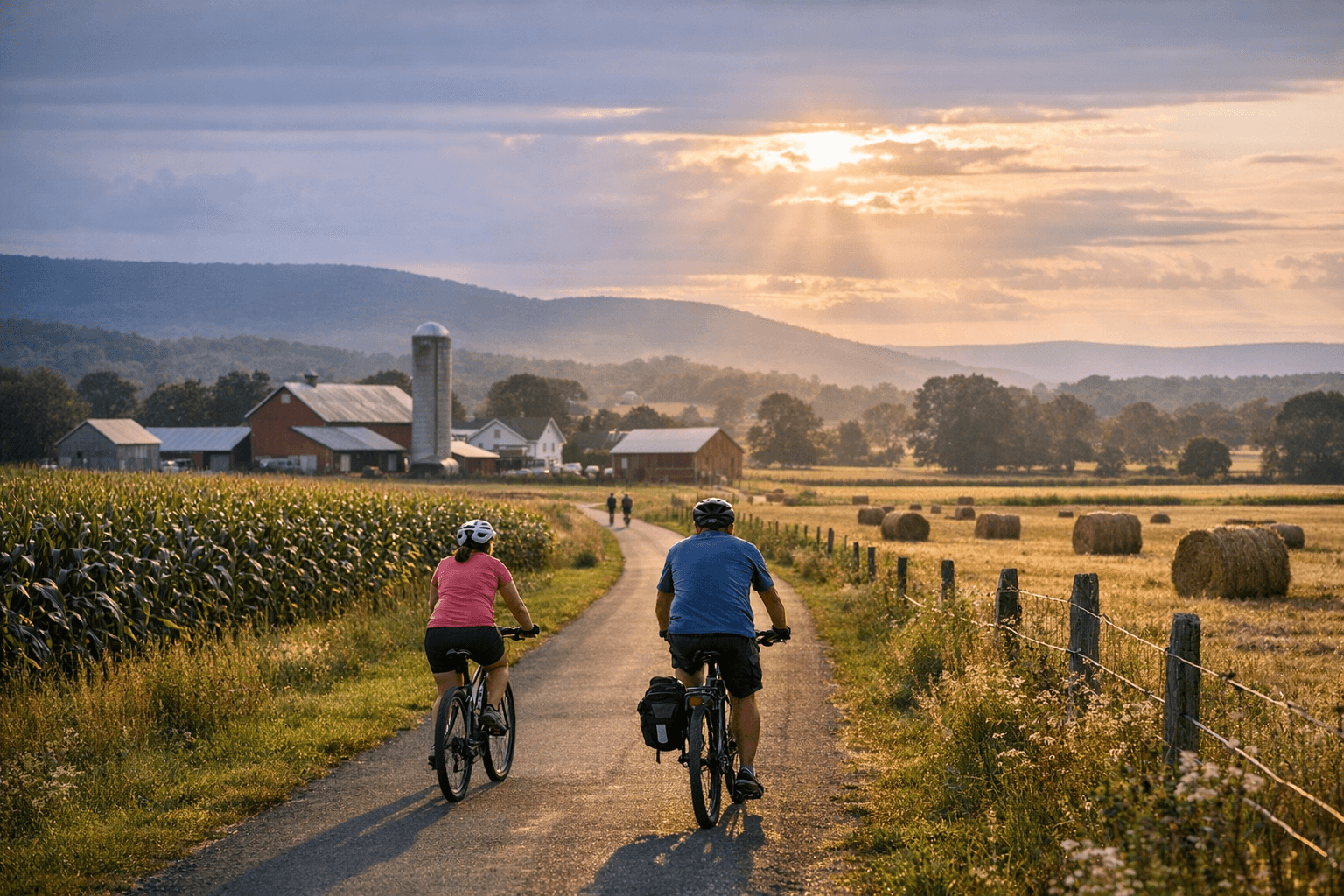
Buffalo Valley Rail Trail connects Lewisburg and Mifflinburg through scenic farmland
Buffalo Valley Rail Trail links Market Street in Lewisburg and N. 10th Street in Mifflinburg across roughly 9–9.5 miles of farmland, with restrooms at Lewisburg, Vicksburg (40°56’30.66″N, 76°59’2.58″W), and Mifflinburg.

The Buffalo Valley Rail Trail connects Market Street in Lewisburg to N. 10th Street in Mifflinburg along roughly 9–9.5 miles of former railroad right-of-way, providing a continuous recreational corridor through Buffalo Valley farmland that opened in phases between 2011 and 2015. Sources list the trail length as 9 to 9.5 miles - DCNR/ExplorePAtrails records 9 miles, a BVRT facts box lists 9.3 miles, and Buffalo Valley Recreation Authority and UnionCountyTrails materials report 9.5 miles.
The corridor follows a rail alignment with deep local roots: the Lewisburg Centre & Spruce Creek Railroad was incorporated in 1853, suffered the St. Patrick’s Day flood of 1865, was renamed the Lewisburg & Tyrone Railroad Co. in 1879, and the line ceased operations in 1982. After planning and feasibility work, BVRA acquired the West Shore Railroad right-of-way in 2009, and Phase I — "including nine miles of finished trail, trailheads, facilities, and parking areas" — was completed in the fall of 2011; Phase II work extending the trail into the heart of historic Lewisburg was finished in October of 2015.
Development and funding for the project involved Buffalo Valley Recreation Authority, Union County, the Pennsylvania Department of Conservation and Natural Resources, and PennDOT, and BVRA materials note the administrative change: "ATTENTION: The Buffalo Valley Rail Trail was transferred to UNION COUNTY effective July 1, 2019." The BVRA page lists a contact phone number of (570) 524-3878, and official maps and up-to-date trail information are available through UnionCountyTrails.org as cited by VisitCentralPA.
Surface and access details matter for users: the trail is a mixture of asphalt and hard-pack gravel, described on BVRT materials as "a protected spine of asphalt and gravel" with "some sections are paved, but most of it is a hard pack gravel surface" noted in user reports. The trail is advertised for biking, inline skating, wheelchair access, mountain biking, walking, and cross-country skiing, and DCNR/ExplorePAtrails specifically notes rest rooms and parking at each end, with limited parking and an outhouse near the midpoint.
Trailheads and parking are explicit: vehicle parking is available at the Lewisburg and Mifflinburg endpoints and in Vicksburg, with Vicksburg parking coordinates listed as 40°56’30.66″N, 76°59’2.58″W. Directions to the Lewisburg trailhead are provided verbatim on BVRT signage: "From the Rt 15 and Rt 45 intersection, head west on Rt 45, away from downtown Lewisburg. Go to 15th St and turn right/north. Look for parking lot entrance just before the rail trail crosswalk."
Agricultural context and safety are central to trail rules: UnionCountyTrails warns that "The Buffalo Valley Rail Trail neighbors multiple farms throughout the length of the trail. There are 7 crossings (shown on the map below) where trail users should be cautious of farm machinery potentially crossing the trail," and advises users to confirm that machinery operators see them, stay on the trail, and not feed or harass livestock. Local trail reporting also notes frequent stops and starts at farm access roads and describes "beautiful pastoral views and window into the valley agricultural economy."
Usage and community value are well established in the record: BVRA and UnionCountyTrails materials state that "thousands of residents and visitors have walked, run, or biked" the corridor since opening, and promotional language on BVRT materials invites people to "Join us on the trail to connect, revitalize, and get a breath of fresh air!" For maps, trail rules, and the latest operational details, consult UnionCountyTrails.org and BVRA materials; photographers and visitors who post can tag @purplelizardmaps, a local trail reporter who has documented views along the route.
Know something we missed? Have a correction or additional information?
Submit a Tip