El Niño likely soon, NOAA warns of heat, drought and flooding
NOAA says El Niño is likely to emerge soon, raising the odds of wetter Southern states, shifting jet streams and renewed heat, drought and flood risks.

El Niño is moving back onto the U.S. weather map, and NOAA says the pattern could reshape where heat, drought, flooding and agricultural stress show up over the next year. The National Weather Service and NOAA Climate Prediction Center say El Niño is likely to emerge soon, with an 82% chance in May-July 2026 and a 96% chance of continuing through Northern Hemisphere winter 2026-27.
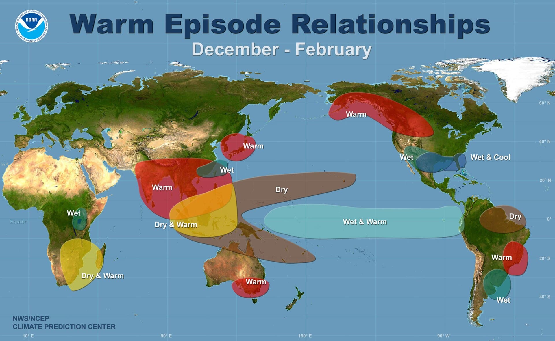
That matters because El Niño is the warm phase of the El Niño-Southern Oscillation, or ENSO, and NOAA says it can strongly influence weather across the United States by shifting rainfall patterns in the tropics and altering jet stream tracks. In practical terms, that often means wetter conditions in parts of the southern United States, while other regions can face hotter, drier or more volatile stretches depending on the season and how the atmosphere responds.
NOAA’s historical record puts the coming season in a serious context. The agency’s past-event listings include some of the strongest El Niño years on record, including 1997-98 and 2015-16. NOAA’s Physical Sciences Laboratory tracks those major episodes using long-term sea-surface and atmospheric indices, and the Climate Prediction Center uses historical ENSO seasons to build U.S. impact maps for temperature, precipitation and snowfall. Those maps are meant to show how a single ocean-atmosphere pattern can translate into very different risks for farmers, utilities, water managers and households.
For the southern United States, the signal often leans wetter, with above-normal precipitation favored across portions of the Southeast. Elsewhere, the same pattern can raise the odds of fire weather, drought persistence or flood-prone storm tracks as jet stream behavior changes. That is why forecasters are watching not just whether El Niño appears, but how quickly it strengthens and how far it spreads across the tropical Pacific.
NOAA has used the same framework in past years to identify when El Niño conditions were present and expected to intensify into winter. The stakes this time are the same: planting decisions, reservoir planning, emergency preparation and household readiness all turn on whether the atmosphere follows the script or drifts away from it.
This article was produced by Prism’s automated news system from verified source data, official records, and press releases, then run through automated quality and moderation checks before publishing. The system is built and supervised by the people who set the standards it runs under. Read our full AI policy.
Did this article answer your question?