How Utqiaġvik, Point Hope, Wainwright and Prudhoe Bay receive supplies
Fuel, groceries and heavy rigs reach Utqiaġvik, Point Hope, Wainwright and Prudhoe Bay through a mix of year‑round air, summer barges, winter ice roads and the Dalton Highway — each community uses those modes differently.
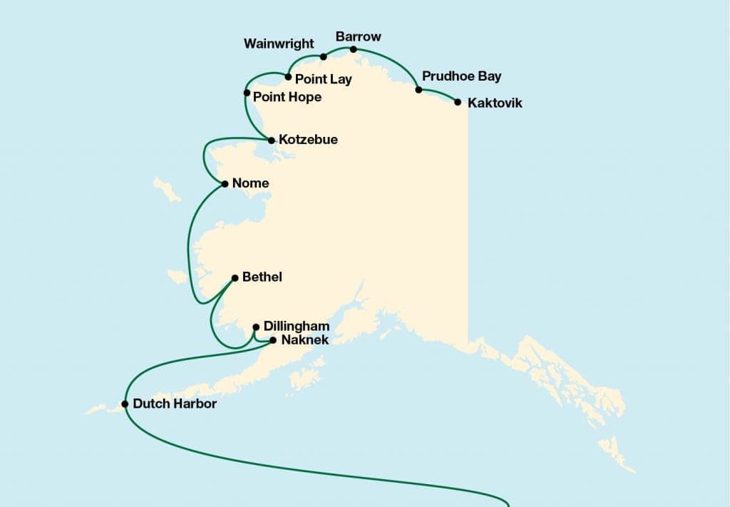
Fuel, groceries, construction materials and heavy equipment that keep North Slope towns and oil operations running move through a tightly scheduled, multi‑modal system shaped by Arctic seasons, limited infrastructure and long distances. Alaska covers 586,412 square miles and most Northwest & Arctic communities are small (25–800 residents), so logistics teams balance air cargo, barges, ice roads and specialized heavy transport to keep supplies flowing.
1. Utqiaġvik / Utiqiagvik
Utqiaġvik appears in source material under both spellings and is listed as one of the larger hub communities serving the Northwest & Arctic region. As a hub, Utqiaġvik receives year‑round air cargo for perishables and mail, and when water access permits in summer it can accept barge freight for heavier goods; dot‑Alaska planning materials note that lighter goods typically move by air while bulk fuel and building materials arrive by ocean‑going barge where docks and water access exist. The town’s role as a hub connects smaller villages to regional supply chains and distribution centers such as Fairbanks, which Transportalaska cites as an origin point for Arctic freight flows. Given the North Slope’s “zero‑margin” logistics environment, companies serving Utqiaġvik emphasize precision and contingency planning to avoid supply interruptions during weather or seasonal transitions.
2. Point Hope
Point Hope, a small coastal community, depends on year‑round air service for time‑sensitive items and on summer maritime operations for bulk goods when sea lanes and docking conditions allow. Many west coast communities like Point Hope lack permanent dock infrastructure, so operators use beach ramp landings and specialized craft; as McKallor observes, “You have to land on a beach like the Marines with big ramps that drop down or use Hovercraft to navigate shallow rivers and then go right up the beaches to these villages.” Because winter ice and snow change connectivity, planners often pre‑position materials and schedule deliveries around narrow marine windows — a point emphasized in industry reporting: “During large parts of the year, marine operations are impossible due to the ice… so planning ahead on projects and community resupply is critical.” Span Alaska’s approach — “using a combination of modes and equipment—to deliver to the key population centers and even the most remote bush villages and North Slope communities”—illustrates the multi‑modal tactics used for places such as Point Hope.
3. Wainwright
Wainwright’s supply chain follows the same Arctic playbook: small‑plane deliveries for perishables and urgent freight, summer barges for heavier loads where water access is possible, and overland movement via snow machine, ATV or ice roads during winter when routes freeze. The industry notes that many of these communities are served primarily by small aircraft — examples include 185 Cessnas — because local runways and demand do not support larger planes; McKallor states that air service “is often limited to small aircraft such as 185 Cessnas.” For bulky construction materials and fuel, operators coordinate barge lifts and beach transfers where docks are absent; hovercraft or beach ramp systems are alternatives when shallow rivers or tidal flats prevent conventional offloading. Logistics providers also stress the need for broadband and precise shipment tracking in communities like Wainwright: “Given that more than 70% of Alaska’s communities are only served with small aircraft or seasonal barges, having precise tracking through access to greater broadband will facilitate better management and shipping analysis,” Lochner says.
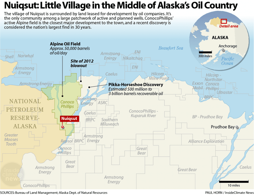
4. Prudhoe Bay (Prudhoe Bay operations)
Prudhoe Bay’s supply picture is distinct because it services North Slope oil field operations and connects to the mainland highway system via the 414‑mile Dalton Highway, a gravel service road that parallels the Trans Alaska Pipeline System. The Dalton is the primary land freight corridor to the oil fields and links Prudhoe Bay to public highways, making it central for heavy and specialized transport moving drilling equipment and large infrastructure. Transportalaska highlights the region’s high‑stakes timing: “When energy companies need emergency equipment during brief operational windows, when drilling operations require precision timing for material delivery during Arctic conditions, or when remote facilities depend on critical supply deliveries for continuous operations, the Slope's extreme environment and zero‑margin logistics requirements demand specialized solutions that only Arctic experts can provide.” Accordingly, Prudhoe Bay logistics are built around specialized heavy transport providers, pre‑staged supplies at Fairbanks distribution centers, and carefully timed road hauls along the Dalton during the accessible season.

- Mode selection by cargo type: Lighter goods (mail, perishables) move predominantly by air year‑round; bulky items (fuel, dry goods, building materials) move by barge when summer marine access exists; heavy drilling equipment uses specialized heavy transport coordinated to narrow windows.
- Seasonal constraints: Marine operations are impossible for large parts of the year due to ice, making pre‑positioning and long lead times essential. Industry sources emphasize planning: “During large parts of the year, marine operations are impossible due to the ice… so planning ahead on projects and community resupply is critical.”
- Offloading improvisations: In places without dock facilities, logistics teams use beach ramp landings, hovercraft for shallow rivers, and direct beach offloads — tactics described by McKallor and used widely in western and Arctic coastal communities.
- Multi‑modal solutions and tracking: Span Alaska’s Johnson describes the operational response: “Alaska’s size and remoteness can make reliable transportation a challenge for all providers… We pride ourselves on finding a solution—using a combination of modes and equipment—to deliver to the key population centers and even the most remote bush villages and North Slope communities.” Lochner highlights technology gaps and opportunities: better broadband and tracking would “facilitate better management and shipping analysis,” especially where more than 70% of communities rely on small aircraft or seasonal barges.
Operational patterns and tactics across all four communities
Regional context and scale The Northwest & Arctic region includes 54 communities plus the North Slope oil fields, and most communities in that region have populations between 25 and 800. By comparison, the Yukon‑Kuskokwim Delta covers 59,000 square miles and contains 56 remote communities with Bethel as a hub of roughly 6,300 residents. These figures underscore the extreme geographic scale and fragmentary network that logistics providers must knit together across Alaska’s 586,412 square miles.
Who moves what and who to call Major players combine regional distribution nodes (Fairbanks distribution centers) with local carriers, charter air operators and specialized heavy‑haul firms. Transportalaska markets itself as an Arctic logistics provider and notes it connects “supply chains from Fairbanks distribution centers to energy companies, remote facilities, and critical infrastructure” and that it is “Home to Patriot Logistics' specialized Arctic operations expertise.” Contact details printed in source material for Transportalaska are (907) 414‑3222 and info@transportalaska.net for readers seeking the company’s logistics team.
Conclusion Keeping Utqiaġvik, Point Hope, Wainwright and Prudhoe Bay supplied requires sequencing and redundancy: air for speed, barges for scale, ice roads and trails for winter mobility, and heavy‑haul corridors like the 414‑mile Dalton Highway for oilfield infrastructure. As operators stress, the Arctic’s “zero‑margin” environment demands careful advance planning, multi‑modal contingency plans and better tracking and broadband to tighten timing — practical priorities that will shape reliability and costs for North Slope communities and industry in the years ahead.
Know something we missed? Have a correction or additional information?
Submit a Tip