Magnitude-6.2 quake off northern Sumatra shakes Aceh and Malaysia coasts
USGS recorded a magnitude 6.2 quake 62 km SE of Sinabang at 04:56:46 UTC; agencies report depths 10-26 km and no tsunami warning or immediate casualties.
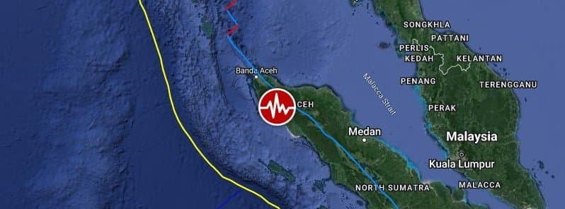
A strong earthquake struck offshore northern Sumatra early March 3, 2026, the U.S. Geological Survey recorded as a magnitude-6.2 event (USGS event us7000s1ln) at 04:56:46 UTC, with an epicentre roughly 62 kilometres southeast of Sinabang and a shallow depth of about 18 kilometres. The tremor was widely felt across Aceh province and into northern Peninsular Malaysia, but authorities said there was no tsunami warning and there were no immediate reports of casualties or major damage.
Seismological networks reported a range of initial measurements as automatic processing algorithms produced differing values in the first hour after the quake. GFZ, IRIS and EMSC registered magnitudes near 6.1 while INGV and RaspberryShake recorded about 6.3; one regional bulletin cited a 6.5 reading. Depth estimates varied from 10 to 26 kilometres across agencies. Indonesian and international agencies typically revise numbers as more data are reviewed, a normal part of early post-event analysis.
Indonesia’s Meteorological, Climatological and Geophysical Agency, BMKG, listed the event offshore the west coast of northern Sumatra and confirmed there was no tsunami potential. Malaysia’s meteorological authority, MetMalaysia, gave coordinates of 2.0 degrees north and 96.5 degrees east, placed the epicentre about 112 kilometres southeast of Simeulue and said the quake occurred at a depth of 10 kilometres. MetMalaysia said tremors were felt across the northern states of Peninsular Malaysia and added, "There is no tsunami threat to Malaysia." It asked members of the public who felt shaking to submit felt reports through its survey system to help map local intensity.
Local officials in Aceh and provincial emergency services remained on alert for aftershocks, a common follow-up risk after shallow offshore quakes. Indonesian emergency management authorities had not reported structural collapses or a need for mass evacuations in the first hours after the shaking, and regional governments in Malaysia and Thailand said they were not seeing significant impacts. Neighboring India also reported no significant effects.

Seismologists note that shallow earthquakes beneath the sea can transmit strong shaking to nearby coastlines even when they do not generate tsunamis, because energy is released close to populated areas. Indonesia sits on the Pacific Ring of Fire and on several active plate boundaries, including fault systems around Sumatra that have produced damaging earthquakes in the past. Historical context underscores the need for rapid local assessment: a 2022 earthquake in West Sumatra with a similar magnitude produced major local damage and casualties because it struck at a very shallow depth on land.
Reporting remains preliminary. Authorities in Jakarta and Aceh will likely issue updated bulletins as agency analyses converge. Journalists and residents should follow official BMKG and MetMalaysia channels for confirmed advisories and any evacuation instructions.
This article was produced by Prism’s automated news system from verified source data, official records, and press releases, then run through automated quality and moderation checks before publishing. The system is built and supervised by the people who set the standards it runs under. Read our full AI policy.
Did this article answer your question?