North Slope Borough Joins 2025 International Aerial Survey Finding Bowhead, Beluga
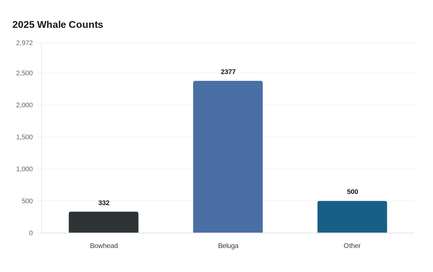
Alaska North Slope Borough teamed with NOAA Fisheries in a 2025 Beaufort Sea aerial survey that logged 332 bowhead and 2,377 beluga sightings across U.S. and Canadian waters.

Alaska North Slope Borough’s Department of Wildlife Management joined NOAA Fisheries in an international, multi-agency aerial survey in 2025 that recorded hundreds of whales across the Beaufort Sea and into the Amundsen Gulf. NOAA’s social post reported that “they saw more than 3,000 animals, including 332 bowhead whales, 2,377 beluga whales and 500 other marine mammals,” and said the three teams flew more than 30,000 miles during the operation.
NOAA Fisheries describes the project as co-led by NOAA and performed in partnership with the Alaska North Slope Borough. Fisheries NOAA’s materials list the operational period as July 28 to August 24, 2025, while North Slope Borough documents report the survey was flown July 27 to August 25, 2025; both sources note the teams worked within a 28-day window after three years of planning. Each survey team’s stated goal was to complete all transect lines in its area within that window.
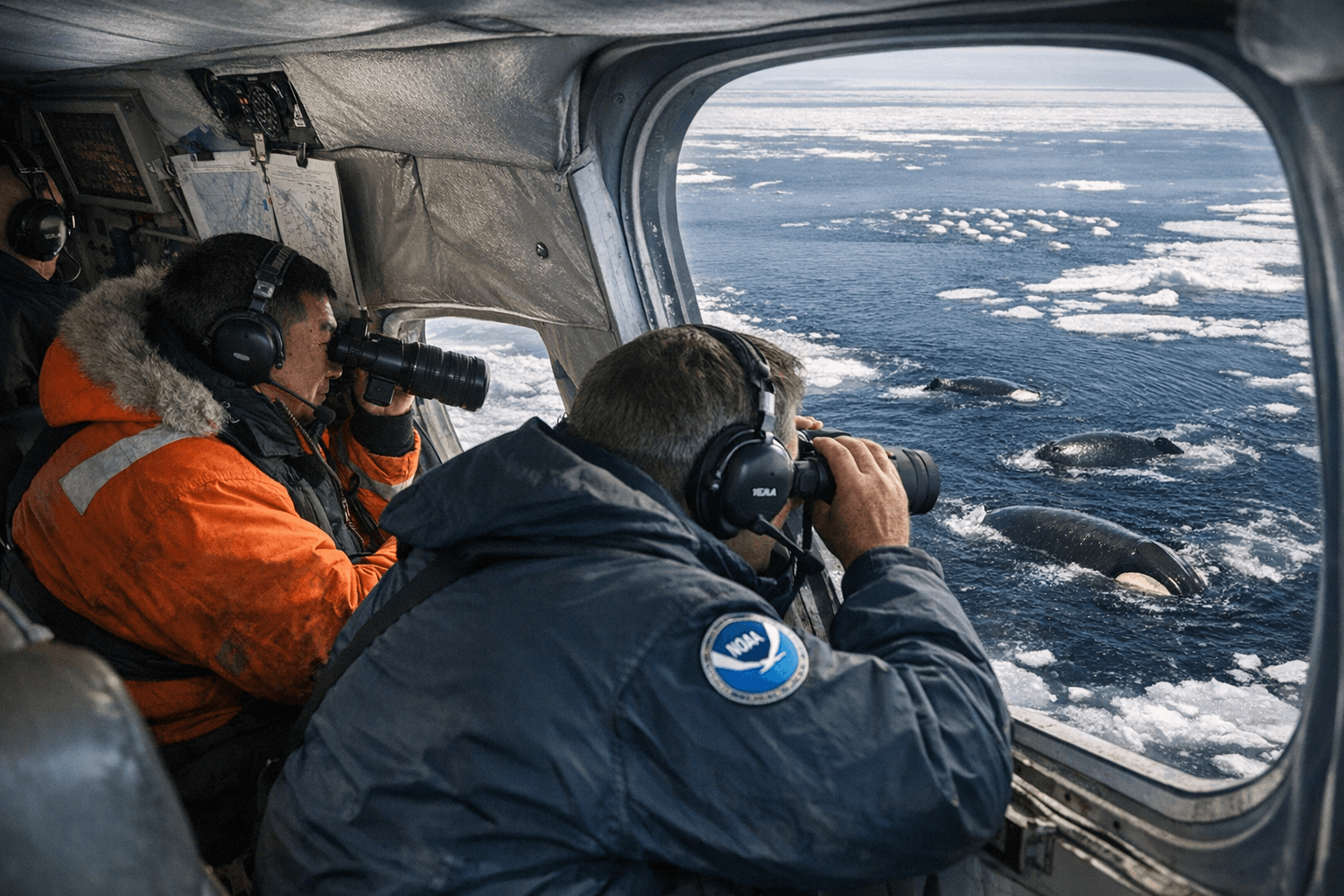
Logistics and field operations were concrete: three Twin Otter aircraft were used, one NOAA-operated Twin Otter based in Deadhorse, Alaska, and two Kenn Borek Air-contracted Twin Otters operating from Inuvik, Canada. “Each team consisted of at least two pilots, three scientists, and a land-based engineer who prepped the planes and took care of any maintenance issues,” NOAA materials say. Teams photographed animals through side and belly windows under NOAA research authority, and NOAA’s social media noted the combined flight effort exceeded one circumnavigation of Earth.
The survey’s aims were explicitly tied to subsistence and management. NOAA materials say the work “will directly contribute to continued food security of Iñupiat and Inuvialuit communities in villages of the Alaskan and Canadian Arctic.” BOEM planning documents situate the 2025 effort in a long-term program of aerial line-transect monitoring dating to 1979, with objectives to track temporal and spatial trends, migration timing and nearshore distances, and to provide real-time data for BOEM and NMFS on fall bowhead migrations.
The North Slope Borough framed the aerial survey as a hedge against ice-based counting uncertainty. “The ice-based census for counting bowhead whales is only successful in one out of two or three attempts. Because we did not know if the ice-based count would be successful, NSB DWM partnered with the National Oceanic and Atmospheric Administration’s (NOAA) Marine Mammal Laboratory (MML) to fly an aerial survey for bowhead whales,” NSB wrote. NSB further reported they “were able to conduct both an ice-based census with a record count and an aerial survey. We’re still analyzing the data, but initial results indicate that the bowhead population is healthy.”
Reconciling tallies and population estimates will take more analysis. NOAA’s tallyed sightings are clear in the Facebook post; North Slope Borough notes preliminary data “suggest that a similar number of bowhead whales was counted in 2025 as in 2019,” and cites the 2019 population estimate of 17,175. NSB and NOAA say they expect formal abundance estimates and analytical results in 2026 or 2027.
Operational limits affected coverage: North Slope Borough acknowledged “the survey covered less area than was originally planned due to the prevalence of sea ice in the relevant areas,” while Fisheries NOAA noted the two Canadian teams coordinated to extend coverage into the Amundsen Gulf. NSB thanked partner organizations by name, including the Alaska Eskimo Whaling Commission, the Inuvialuit Game Council and the Fisheries Joint Management Committee.
Photographs taken under NOAA Fisheries Research Permit #25563-02 document sightings and flight operations; credit for published images must read: “Photo taken while working under authority of NOAA Fisheries Research Permit #25563-02. Credit: NOAA Fisheries & CICOES / Skyla Walcott.” Final abundance estimates and spatial analyses expected in 2026 or 2027 will determine how the 2025 survey informs subsistence management, BOEM and NMFS protection actions, and long-term trend assessments for Arctic whales.
Know something we missed? Have a correction or additional information?
Submit a Tip