Rocky Mountain snowstorm could be biggest of season, forecasters warn
A late-season storm threatened more than 2 feet of snow in the Rockies, with outages and travel disruptions possible along the Front Range and I-25.

A heavy, wet snowstorm moved into the Rocky Mountains on Tuesday with the potential to become the biggest of the season, forecasters said, turning a spring week into a test of roads, power lines and mountain preparedness.
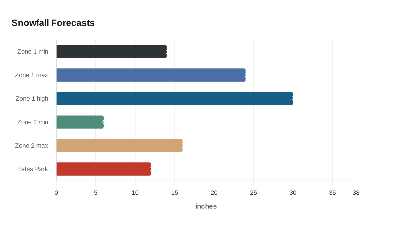
The National Weather Service office in Denver/Boulder said the late-season system could dump locally more than 2 feet in the northern mountains and foothills, with a winter storm warning in effect until 3 p.m. MDT Wednesday for Rocky Mountain National Park, Estes Park, Nederland, the Medicine Bow Range and higher elevations in Boulder, Larimer, Grand, Gilpin, Clear Creek, Summit and Park counties. In one warned zone, snowfall was forecast at 14 to 24 inches, with isolated totals up to 30 inches possible in the higher mountains of Boulder and Larimer counties. Another zone covering parts of Summit, Gilpin, Clear Creek, Jefferson and Park counties was expected to pick up 6 to 16 inches, with the heaviest snow generally along and north of I-70.
Forecasters warned that the snow’s weight was as much of a problem as the totals. Heavy, wet accumulations were expected to damage tree limbs and power lines and trigger scattered outages along the Front Range and the I-25 corridor. Slick and slushy roads were possible overnight into Wednesday morning, especially where snowfall wrapped into the foothills and lower-elevation corridors.
Colorado transportation officials urged motorists to prepare for rapidly changing conditions, check road updates before leaving and pack snow kits and emergency supplies. The National Weather Service also advised drivers to keep emergency supplies in vehicles and charge phones and portable chargers ahead of possible outages. The storm was expected to taper off from north to south late Wednesday morning into the afternoon, with warmer weather returning later in the week.
The system underscored how abruptly the Rockies can swing back into winter even as spring travel and mountain commerce are underway. A foot of snow had already been reported in Estes Park, and Interstate 80 was closed in both directions between Cheyenne and Laramie, a reminder that the storm’s reach extended well beyond Colorado. Denver and Cheyenne typically average just 1 to 3 inches of May snowfall, making a major storm in early May unusual but not unprecedented.
Denver’s snowfall history also puts the event in context. Official observations have been taken since 1882, first downtown, then at Stapleton and Central Park, and now at Denver International Airport, where the current seasonal average is listed at 49 inches. Forecasters said that figure likely understates the city’s true average, which is probably closer to 56 inches because the airport site records only one observation per day. Even so, a storm of this scale in May is the kind that can close roads, interrupt power and force mountain communities to brace for a winter-style response long after people expect spring to have arrived.
This article was produced by Prism’s automated news system from verified source data, official records, and press releases, then run through automated quality and moderation checks before publishing. The system is built and supervised by the people who set the standards it runs under. Read our full AI policy.
Did this article answer your question?