Storm Dave to Lash UK With 80mph Winds Over Easter Weekend
Storm Dave will bring 80-90mph gusts to Scotland's coast this Easter, with blizzard conditions, widespread ferry disruption and power cuts expected across the north.

Gusts of up to 80-90mph are forecast to batter Scotland's Western Isles and Skye this Easter weekend as Storm Dave, the fourth named storm of the 2025/26 season, rapidly deepens and moves in from the west, triggering warnings for wind, snow, and dangerous coastal conditions across northern Britain.
The Met Office, which named the storm on 2 April in partnership with Met Éireann and the Royal Netherlands Meteorological Institute, has issued Yellow wind warnings covering Scotland, Northern Ireland, North Wales, and parts of northern England from Liverpool to Newcastle. Scotland's main warning runs from 6pm on Saturday 5 April to midday on Easter Sunday; Northern Ireland's is in effect from 14:00 BST Saturday to 02:00 Sunday. A separate warning covers Orkney and Shetland for the entirety of Easter Sunday.
Deputy Chief Forecaster Tom Crabtree said the storm "will form and rapidly deepen on Saturday as it approaches the UK from the west," urging people to prepare their property and monitor updated forecasts. Coastal areas of Aberdeenshire and Moray can expect 70-80mph gusts peaking in the early hours of Easter Sunday. Inland, 60-70mph winds will spread from Argyll eastward through the night, with 50-60mph likely more broadly across northern England.
A Yellow snow warning is also in force for northwest Scotland from 15:00 Saturday to 03:00 Sunday, with accumulations of 5-10cm possible above 200m and up to 10-20cm in some locations. The combination of wind and snow will produce full blizzard conditions with near-zero visibility across the hills and mountains of the northwest.
Storm Dave carries added historical weight: it is the biggest storm to hit Northern Ireland since Storm Chandra in January 2026, and sets a calendar record as the latest D-named storm ever, beating Storm Doris which was named on 21 February in a prior season.
Scottish and Southern Electricity Networks has activated its Weather Warning preparedness level, positioning engineering teams at strategic locations across its network. Power cut risk is highest in the Western Isles, Skye, and the Highlands on Saturday and Sunday, followed by Orkney, Shetland, and the northeast on Sunday. The emergency power cut number is 105. Households should gather torches, spare batteries, and phone power packs now, as power cuts could also knock out mobile coverage.
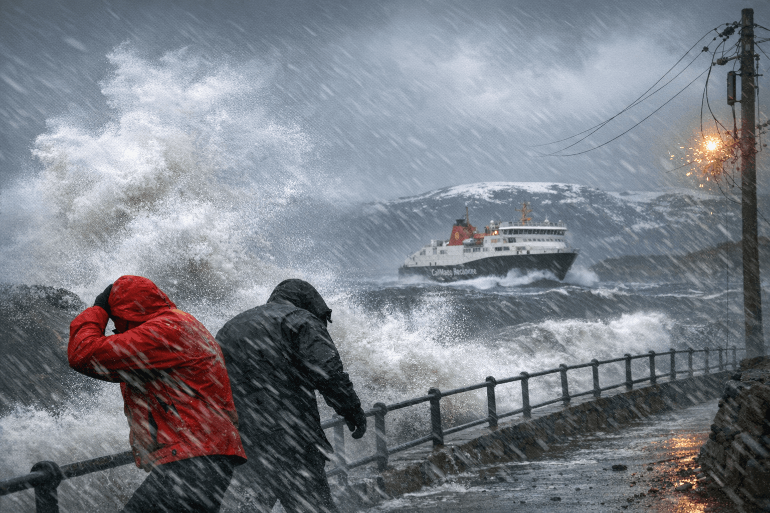
CalMac has warned of "widespread disruption" across its island ferry network, with cancellations expected on multiple routes once winds exceed the 50mph threshold at which it typically suspends sailings. NorthLink Ferries has also advised Orkney and Shetland passengers of potential disruption. Bridge restrictions for high-sided vehicles are likely on exposed routes, and Transport Scotland's Resilience Room and Multi-Agency Response Team will monitor conditions, with Traffic Scotland providing real-time updates from its National Traffic Control Centre in South Queensferry.
RAC spokesperson Rod Dennis warned that despite slightly lower leisure traffic on Saturday and Sunday, "millions of people" will still be on the roads, urging drivers not to "underestimate the impact of the very strong winds" and to take extra care on exposed, higher routes. Chief Superintendent Scott McCarren, Police Scotland's head of Road Policing, was direct: "Our advice is to plan ahead and consider if your journey is really necessary or if it can be delayed until conditions improve."
The Met Office cautioned that large breaking waves "can sweep you off your feet and out to sea" even from the shore, urging the public to stay well back from cliffs and coastlines and to call 999 and ask for the Coastguard in an emergency.
The name Dave was submitted by a member of the public in tribute to "my beloved husband who can snore three times louder than any storm.
Sources:
Know something we missed? Have a correction or additional information?
Submit a Tip

