First-Time Visitors Guide to Safety, Permits, and Access at Four Corners
The Four Corners region rewards prepared visitors and punishes unprepared ones — here's what you actually need to know before heading out.
Few places in the American West concentrate so much adventure potential into a single region as the Four Corners. Moab to the north, Durango and Telluride anchoring the Colorado side, Monument Valley stretching south into Navajo Nation territory — this is high-desert, canyon, and mountain country all at once, and it plays by its own rules. If you're coming in for the first time, the gap between a great trip and a genuinely dangerous one often comes down to a handful of decisions made before you leave the trailhead parking lot.
This guide covers what first-timers consistently get wrong, what permits and access considerations you need to sort out in advance, and how to move through this landscape without getting yourself into serious trouble.
Know the terrain before you commit
The Four Corners region is not one ecosystem — it's several stacked on top of each other. Moab sits in canyon country at roughly 4,000 feet elevation, but the surrounding Manti-La Sal Mountains push past 12,000. Durango and Telluride operate at higher base elevations, with mountain passes and trails that can hold snow well into June. Monument Valley sits on the Colorado Plateau at around 5,500 feet in a landscape defined by sandstone buttes, open desert, and limited shade.
Understanding which zone you're entering changes everything about how you prepare. Desert canyon terrain in the Moab area means intense midday heat from May through September, limited water sources, and slickrock surfaces that are deceptively grippy when dry and treacherously slick when wet. The Colorado mountain gateways around Durango and Telluride demand awareness of afternoon thunderstorm cycles, altitude acclimatization, and the very real possibility of rapid weather changes at elevation. Don't plan a high-alpine trail run for 2 p.m. in July without understanding what that means.
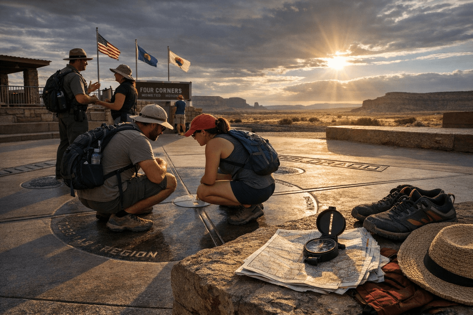
Access and jurisdiction: It's more complicated than you think
One of the most common mistakes first-timers make in this region is assuming all public land operates under the same rules. It doesn't. The Four Corners area encompasses Bureau of Land Management (BLM) land, National Park Service units, National Forest land, and the Navajo Nation — a sovereign tribal nation with its own entry requirements, fees, and regulations.
Monument Valley is located within the Navajo Nation Tribal Park, and accessing it requires paying a tribal park entry fee. More importantly, many areas within the valley are accessible only with a licensed Navajo guide. Venturing off the 17-mile Valley Drive without a guided tour is not permitted, and this rule is enforced. The Navajo Nation takes stewardship of this land seriously, and visitors are expected to respect both the rules and the cultural significance of the sites they're visiting.
On BLM land around Moab, dispersed camping is widely available but not unlimited. High-use corridors like the area around Canyonlands and Arches have seen significant access restrictions in recent years, including timed-entry reservations at Arches National Park during peak season. If you're planning a spring or fall visit, check the National Park Service reservation system well in advance — showing up at the gate without a timed-entry pass during peak windows will turn you away.
Permits: Get them sorted before you go
Permit requirements across the Four Corners region have expanded considerably over the past few years in response to overcrowding and resource damage. Specific trails, river corridors, and overnight zones now require advance permits, and popular slots fill months out.
Key permit categories to research for your trip:
- Overnight backpacking in Canyonlands National Park (The Needles and The Maze districts both require backcountry permits)
- Whitewater permits for multi-day Colorado River trips through Cataract Canyon, managed through the BLM
- Permits for the popular Fisher Towers trail area during peak season
- Camping within Navajo Nation Tribal Park boundaries beyond standard day-use
The San Juan National Forest around Durango and the Uncompahgre National Forest near Telluride have their own dispersed camping rules and some designated wilderness areas with group size limits. If you're bringing a large group or planning an extended stay, read the specific forest order for the district you're entering.
Water, heat, and altitude: The real hazards
Rangers and search-and-rescue teams across this region respond to the same categories of emergency calls year after year: dehydration, heat exhaustion, altitude sickness, and flash floods. All of them are largely preventable.
In canyon country around Moab and Monument Valley, the heat is not abstract. Air temperatures above 100°F are common from June through August, and canyon walls radiate stored heat well into the evening. Carry significantly more water than you think you need: one liter per hour of active hiking in summer heat is a reasonable minimum, not a conservative estimate. Potholes and streams in the desert often contain biological contaminants, so bring a filter even if you expect to find water.
Flash floods deserve specific mention because they kill people in this region every year, often in canyon bottoms that are perfectly sunny at the time. A thunderstorm 30 miles away can push a wall of water through a slot canyon with almost no warning. Before entering any canyon or wash, check the National Weather Service forecast for the entire upstream watershed, not just your immediate location. If there's any thunder in the forecast, reconsider the plan.
At the Colorado gateways, altitude is the variable most visitors from lower elevations underestimate. Durango sits at about 6,500 feet. Telluride is at 8,750 feet, and trails out of town climb from there. Give yourself at least one full day at elevation before attempting strenuous activity, drink more water than usual, and don't push through a headache or nausea — those are your body's signals to slow down.
Respecting the land and the communities
The Four Corners region is not a theme park. Moab is a working community managing a genuine tension between tourism volume and livability. Navajo Nation lands carry profound cultural and spiritual weight. Even BLM desert that looks like empty nothing often contains fragile biological soil crusts, archaeological sites, and sensitive wildlife habitat that can take decades to recover from a single careless footstep off-trail.
Stick to established trails and roads. Pack out everything you pack in. If you're on Navajo Nation land, follow guide instructions without argument — they're not being restrictive for bureaucratic reasons. Leave gates as you find them on any land with grazing permits. And when you're in town, whether that's Moab, Durango, or Telluride, remember that the locals have seen a lot of visitors who treated the place like a disposable backdrop. Being a thoughtful presence matters.
Before you leave home
The preparation window is the best time to catch problems. Run through these before your departure:
- Confirm permit status for every overnight or restricted-access location on your itinerary
- Download offline maps for the entire route — cell coverage disappears fast in canyon and mountain terrain
- File a trip plan with a contact who will call for help if you don't check in
- Check current road conditions, especially for 4WD routes in the Moab area and mountain passes near Telluride and Durango
- Verify Navajo Nation entry requirements and guide bookings if Monument Valley is on your list
The Four Corners rewards people who show up prepared. The terrain, the scale, and the sheer variety of experience available in this region are genuinely exceptional. Getting the logistics right isn't bureaucratic overhead; it's the actual foundation of a trip worth taking.
This article was produced by Prism’s automated news system from verified source data, official records, and press releases, then run through automated quality and moderation checks before publishing. The system is built and supervised by the people who set the standards it runs under. Read our full AI policy.
Did this article answer your question?

