Four Corners Monument Location Has Long Sparked Debate Among Surveyors
The Four Corners Monument may not sit where you think it does — surveyors have debated its true location for decades.
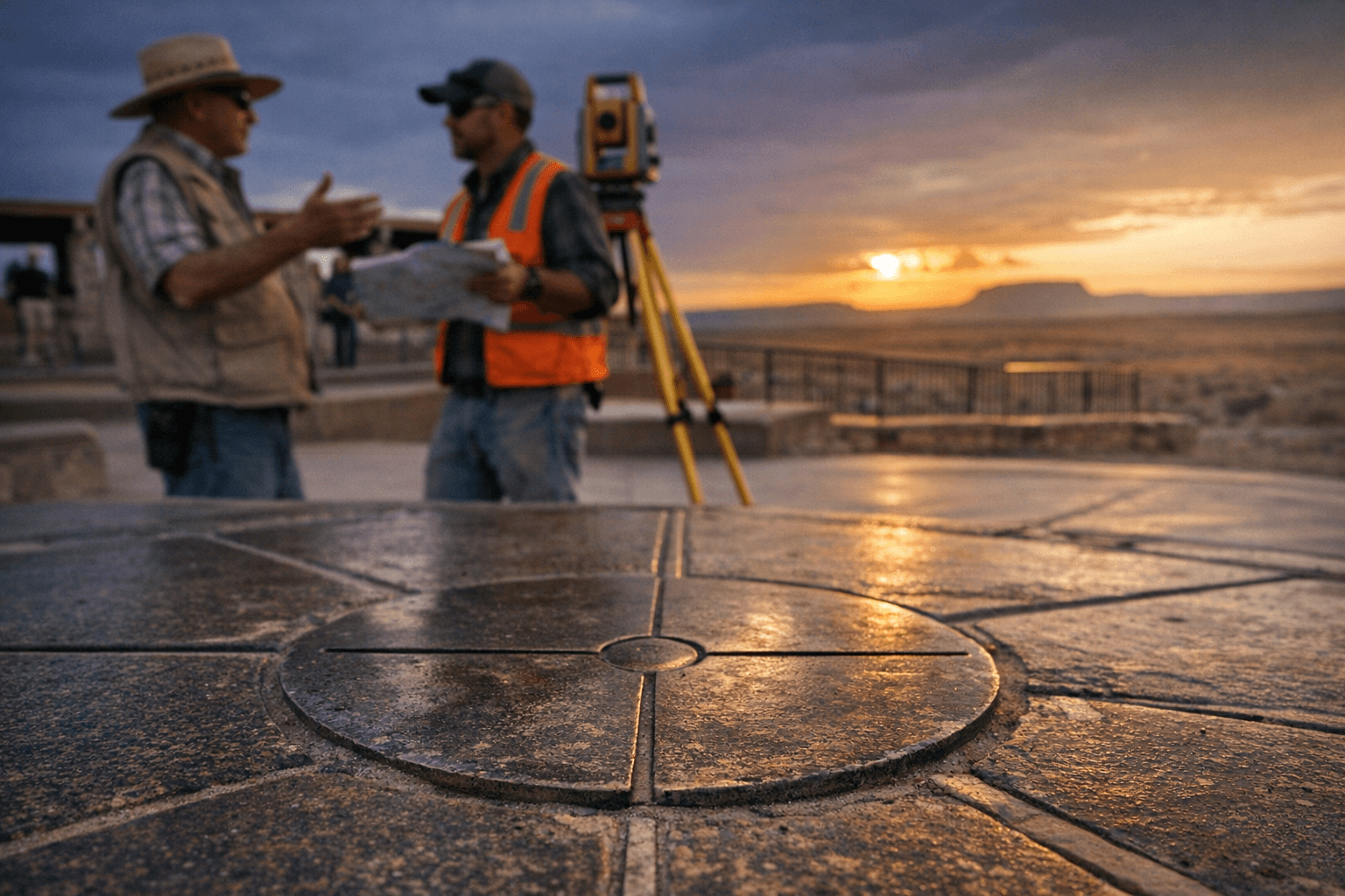
Stand at the Four Corners Monument and you can place one hand in Colorado, one in Utah, one foot in Arizona, and one in New Mexico simultaneously. It's one of the most photographed geographic quirks in the American Southwest, a pilgrimage spot for road-trippers and adventure seekers alike. But here's the thing that tends to stop people cold when they hear it: the marker you're pressing your palm against may not actually sit at the true mathematical intersection of those four state boundaries.
This isn't a new controversy. Surveyors and geographers have been picking at this question for well over a century, and it remains one of the more fascinating technical debates in American cartographic history.
How the monument came to be
The Four Corners region was carved out of federal territory through a series of congressional acts and survey expeditions stretching from the 1860s onward. The boundaries between what would become Colorado, Utah, Arizona, and New Mexico were defined using the best surveying technology available at the time, which meant magnetic compasses, chains, and the kind of painstaking field calculations that could accumulate small errors across vast desert distances.
The original survey work established a physical marker on the ground, and subsequent expeditions came back to verify, re-mark, or relocate that point. Each time surveyors returned, they were working with slightly different equipment, different reference points, and different interpretations of where the original line had been set. The monument that stands today is the product of that layered history.
The core of the surveying dispute
The debate centers on a straightforward but technically thorny question: does the current monument sit at the precise location defined by the original boundary surveys, and do those original surveys accurately reflect the legally intended intersection point?
Surveying across the 19th century American West was extraordinarily difficult work. Teams operated in extreme heat, across terrain with few reliable landmarks, using instruments that required constant calibration. Magnetic declination, the difference between magnetic north and true geographic north, varied across the region and wasn't always perfectly accounted for. Small angular errors compounded over long distances, meaning that a line run for hundreds of miles could end up noticeably offset from where pure mathematics said it should be.
When later surveys used more precise instruments and geodetic techniques, they sometimes arrived at coordinates that didn't quite match where the original markers had been planted. This created a legal and geographic puzzle: do you move the monument to the "correct" mathematical location, or does the original surveyed marker, however imperfect, define the legal boundary by virtue of being the established reference point?
What the law says about survey errors
This is where land law gets genuinely interesting, and it matters to anyone who has ever wondered whether the monument needs to be relocated. Under long-established principles of American boundary law, original survey monuments generally hold legal authority even when later, more precise measurements reveal they weren't placed with perfect accuracy. The surveyed line, once accepted and acted upon, becomes the legal boundary.
That doctrine has kept the Four Corners Monument in place despite the ongoing technical debate about its coordinates. Courts and federal land agencies have repeatedly affirmed that the monument's legal status doesn't hinge on achieving perfect geodetic precision. What was established on the ground by the original surveyors carries legal weight, full stop.
That doesn't make the underlying geographic question any less interesting, though. The gap between the monument's actual position and where a perfectly calculated intersection would theoretically fall has been measured and debated, and while it isn't enormous in absolute terms, it's enough to fuel ongoing conversation among surveyors, geographers, and the kind of dedicated enthusiasts who actually care about this stuff.
Why this matters on the ground
For most visitors, the practical answer is simple: the monument is the monument. You show up, you do the four-state pose, you take the photo. Nobody is going to tell you that your experience doesn't count because of a surveying discrepancy measured in hundreds of feet.
But the debate does have real-world implications in a few areas. Jurisdictional questions, mineral rights, and land management responsibilities can all hinge on exactly where a state boundary falls. The Four Corners region sits atop significant energy resources, and the precise location of state lines affects which state government and which regulatory regime applies to any given piece of ground. That makes the surveying history more than just an academic curiosity.
The Navajo Nation and other tribal territories in the region also have boundaries that intersect with or relate to the state lines, adding another layer of complexity to any discussion about the accuracy and legal status of the original surveys.
Visiting the monument today
The Four Corners Monument is administered by the Navajo Nation Parks and Recreation department, and access requires a modest entry fee. The site sits in a genuinely remote part of the Colorado Plateau, and getting there requires planning. The nearest significant services are in towns like Cortez, Colorado or Farmington, New Mexico, and the monument itself offers limited amenities, typically vendor stalls selling local crafts and food, and the monument plaza itself.
The best times to visit are spring and fall, when the extreme heat of the Arizona and New Mexico desert eases up. Summer visits are entirely doable but pack serious water and be prepared for temperatures that can top 100 degrees on the plaza with limited shade.
If you're making the trip as part of a broader Four Corners adventure loop, the surrounding region is genuinely spectacular. Monument Valley, Mesa Verde National Park, Canyon de Chelly, and the San Juan Mountains are all within reasonable driving distance, making the monument a natural anchor point for a multi-day Southwest itinerary.
The ongoing conversation
The surveying debate around the Four Corners Monument isn't going to be resolved with a new marker or a congressional vote. The legal framework is settled, and the monument isn't moving. What persists is a healthy and legitimate conversation about the limits of 19th-century survey technology, the fascinating legal doctrine that governs how we treat imperfect historical boundaries, and what it means to define a geographic point with absolute precision across hundreds of miles of desert.
For anyone who loves maps, history, and the kind of technical puzzle that has no clean answer, the Four Corners Monument is far more interesting than it looks from the tourist plaza. The coordinates on your GPS and the brass disk under your hand may be telling slightly different stories, and that tension has been quietly fascinating surveyors for generations.
This article was produced by Prism’s automated news system from verified source data, official records, and press releases, then run through automated quality and moderation checks before publishing. The system is built and supervised by the people who set the standards it runs under. Read our full AI policy.
Did this article answer your question?

