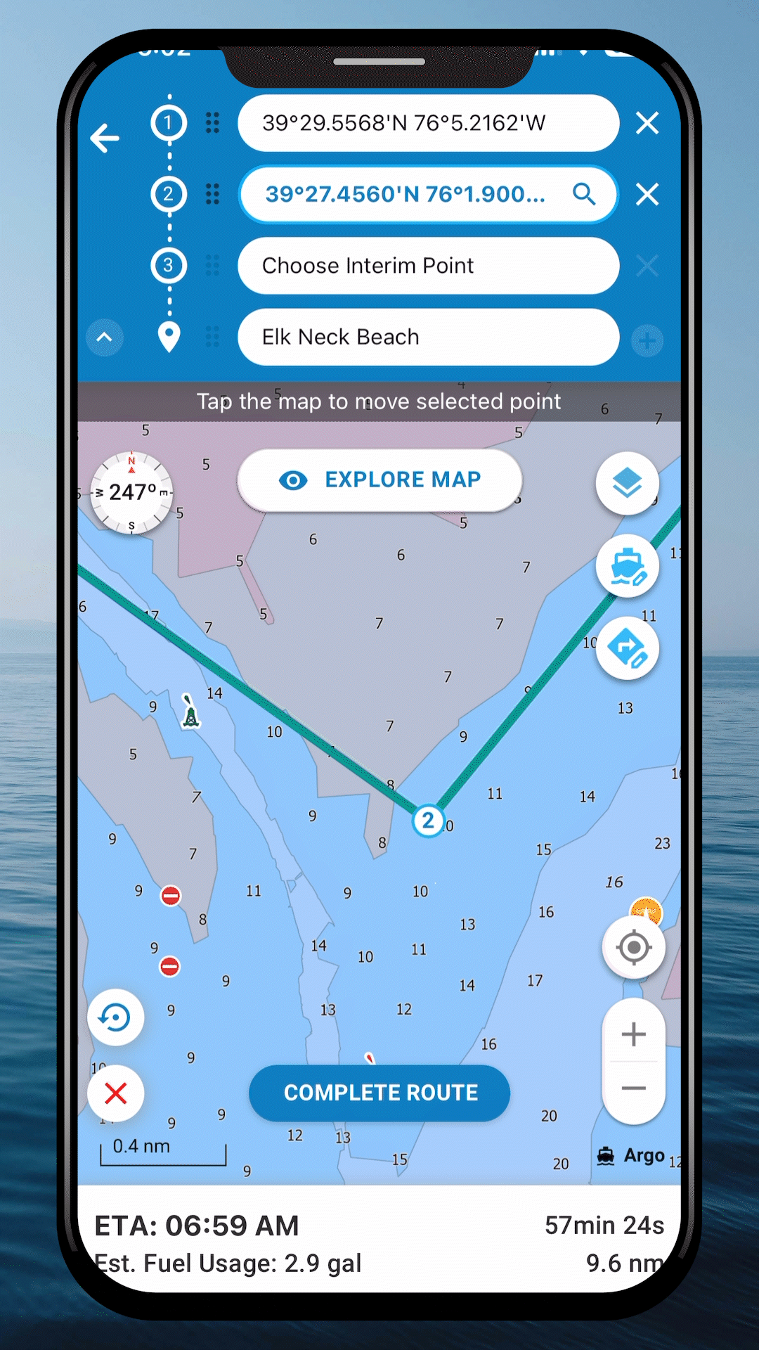
Argo Navigation adds Waypoints for flexible boat trip planning
Argo’s Waypoints turns autorouting into a real passage-planning tool, letting you stitch together safer coastal runs with stops, weather windows, and practical detours.
Why this feels like a real cruising upgrade
If you have ever trusted a one-tap route only to realize it ignored a shallow patch, a fuel stop, or a better anchorage, Argo’s new Waypoints feature speaks directly to that problem. The update shifts Argo Navigation from rigid point-to-point guidance toward trip planning that matches how you actually run a boat: with detours, timing decisions, and a constant eye on what lies between departure and destination.
That is the big change here. Waypoints is built for multi-stop routing, so you can shape a route around anchorages, marinas, fuel docks, restaurants, and other planned stops instead of forcing every trip into a single direct line. For coastal cruisers, weekend boaters, and anyone who wants more control over a passage, that makes the app useful before the engine ever starts.
What Waypoints adds to Argo
Argo already built its reputation around boating-specific navigation, and Waypoints extends that idea in a practical way. The company’s product pages say the app combines official charts, crowdsourced updates and reviews, personal waypoints, routes and tracks, plus premium autorouting tools. That matters because the new feature is not working in a vacuum, it is sitting on top of chart data and user-reported information that can help you spot the difference between a clean run and a risky one.
The feature also gives you more control over the style of trip you want to make. You can stay closer to shore if you want sightseeing and easier access to stops, or push farther offshore if you are looking for smoother water. Argo frames that flexibility as part of the planning process itself, which is the right way to think about it if you are balancing comfort, fuel use, and the realities of local water.
For boaters, that flexibility is the point. A route that looks efficient on paper can still be wrong if it ignores busy channels, wind shifts, currents, or an unexpected obstacle. Waypoints is designed to make the app more of a decision-support tool, not just a map with a destination pin.
How to use it for a safer coastal run
The most useful way to think about Waypoints is as a planning layer between your boat and the water. Before you commit to a course, you can sketch the trip in stages: where you want to stop, what kind of water you want to cross, and what hazards or time limits need to be respected. That is a much better fit for real cruising than letting the app guess your intent from one departure point and one arrival point.
A simple workflow looks like this:
1. Set up your boat profile carefully.
Argo warns that you should enter the boat’s draft and buffer settings correctly so autorouting stays clear of shallow or hazardous water.
2. Plot the trip around real needs.
Add fuel docks, marinas, anchorages, or a restaurant stop if that is how the day will actually unfold.
3. Decide whether you want the inside route or the offshore run.
Waypoints lets you choose a track that hugs the coast for easier access or runs farther out when you want better water.
4. Check the route against conditions.
Use the app’s weather, wind, and tides tools on the premium plan, and compare the route to current channels, currents, and local knowledge before you commit.
That is exactly the kind of pre-departure logic that keeps a trip from becoming a cleanup job later. It also helps when you are trying to thread a bridge schedule, wait out a weather window, or avoid arriving at an anchorage after dark.
Why the safety angle matters
Argo’s own positioning makes it clear that safety and convenience are the core goals behind Waypoints, and that is what gives the update real value. A flexible route is not just about comfort. It can reduce stress, save fuel, improve time efficiency, and lower the odds of making a bad call in a tight channel or unfamiliar inlet.
That is especially relevant if you maintain your own cruising setup and know your boat’s limitations better than any app ever will. A navigation system only becomes dependable when the vessel data behind it is accurate, which is why the draft and buffer settings deserve real attention. With those details set correctly, Waypoints can work the way a good mate would: not telling you where to go blindly, but helping you avoid the parts of the route that do not fit your boat.
Where Argo fits in the bigger picture
Argo Navigation, LLC has been building toward this kind of flexibility for years. The company says it launched in September 2019, and its earlier routing updates already included ways to avoid ocean routes and stay within the Intracoastal Waterway or close to shore. Waypoints looks like the next step in that same direction, turning routing from a fixed line into something you can tune to the day, the boat, and the water in front of you.
The growth numbers also suggest the app has found a real audience. Argo says it is trusted by over 300,000 boaters and has 5,000-plus app ratings. The company also marked 500,000 downloads in a September 19, 2024 milestone, while an earlier press kit put it at nearly 450,000 downloads and more than 150,000 actively using boaters across North America. That kind of momentum usually means the product is solving an actual problem, not just adding features for show.
Pricing is straightforward as well. Argo lists a basic free plan and a premium plan at $39.99 per year. If you want the stronger autorouting and the weather, wind, and tides tools that support smarter trip prep, the paid tier is where the planning depth lives. The company’s release notes also show continuing work, including fixes and improvements to Waypoints in a March 1, 2025 release and a March 2026 map-engine update with other routing and navigation changes.
The bottom line is simple: Argo is no longer asking you to accept a straight-line route as good enough. Waypoints gives you a way to build the trip the way coastal boating actually happens, with shoals, fuel docks, weather windows, bridges, and anchorages all shaping the plan before you leave the slip.
This article was produced by Prism’s automated news system from verified source data, official records, and press releases, then run through automated quality and moderation checks before publishing. The system is built and supervised by the people who set the standards it runs under. Read our full AI policy.
Did this article answer your question?