How to Read Storm Structure on Doppler Radar for Sailors
Storm radar is a cockpit decision tool, not a pretty screen. Learn the signatures that say reef now, wait it out, or duck into harbor before the squall line bites.
Storm radar earns its keep when it stops looking like a pretty blob and starts warning you about the next 30 minutes at sea. In Good Old Boat’s second-part guide, Mark Thornton and Brian Vanderlaan push the focus toward revealing storm structure through scanning strategies, which is exactly the shift sailors need when a quick glance is not enough.
Read the radar as a seamanship tool
The whole point is to read what the storm is doing, not just where the rain is falling. That matters because a harmless shower and a dangerous line of convection can look similar at first glance, especially if you are relying on the default display without understanding what the colors and shapes really mean.
U.S. public weather radar is built around the NOAA and National Weather Service WSR-88D system, better known as NEXRAD, which operates at more than 160 locations across the United States, including Alaska and Hawaii, as well as Puerto Rico and parts of the Pacific. NOAA’s Radar Operations Center describes the operational fleet as 159 radars running 24/7 for the weather warning and forecast missions of the National Weather Service, the FAA, and the Department of Defense. This is not niche gear or a specialty sailing add-on. It is the same radar backbone behind the weather products many skippers already check before castoff.
Start with reflectivity, then ask what the shape is telling you
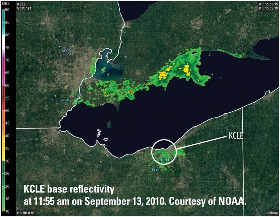
Reflectivity is the most familiar radar product, and NOAA describes it as one of the three base products produced by pulsed Doppler radar. It is the display most mariners recognize first, because it shows where precipitation and severe weather are occurring. The key is not to fixate on the color alone, but on the shape, size, and movement of the returns.
Reflectivity is measured in dBZ, and NOAA’s JetStream materials tie those values to rainfall intensity. For a sailor, that means the screen is not just painting weather in shades of green, yellow, or red. It is hinting at how hard the rain is likely to hit, how badly visibility may collapse, and whether the cell is quiet enough to watch or strong enough to change your plan.
A small, isolated echo moving steadily is one thing. A broadening mass with a sharper edge, faster growth, or a new band forming on the upwind side is something else entirely. That is where the cockpit decision starts to sharpen: keep going, shorten sail, or wait.
The storm shapes that matter most
The biggest mistake is treating every storm signature as if it were a simple shower. Squall lines and bow echoes are a different class of problem, and National Weather Service guidance points to strong surface convergence and high dewpoints near the boundary as important pre-storm ingredients. In plain terms, that means the air ahead of the line is often primed to fuel quick intensification.
When you see a line of storms start to organize, the shape matters as much as the color. A straight line can become dangerous fast, and a bowing segment often signals stronger winds pushing the center outward. For a sailor trying to make a go/no-go call in the next half hour, a bowing line is not a casual observation. It is a strong sign that the weather is consolidating into something more hazardous and that the safe answer may be to reef early or stay in port.
The signatures sailors most often misread
- A “pretty blob” of rain can hide real structure. If the edge is sharpening or the mass is building into a line, treat it as developing convection, not just wet weather.
- A fast-moving line is more concerning than a scattered patch of returns. Movement plus organization means the weather is making a decision for you if you wait too long.
- A bow echo is a red flag. The bowed shape often points to stronger winds and a more aggressive storm mode, which is the kind of feature that can turn a routine crossing into a reef-now call.
- Strong reflectivity without context is not enough. The intensity color matters, but so does the boundary it is riding along and the way adjacent cells are feeding each other.
Dual-polarization adds another layer of confidence
NOAA’s dual-polarization upgrade added three new base products: differential reflectivity, correlation coefficient, and specific differential phase. Those tools help distinguish precipitation types and, in some cases, identify storm structure more clearly. For sailors, the value is not in becoming a radar meteorologist. It is in having more clues when the sky is changing fast and the screen needs to answer a practical question: is this ordinary rain, or is the cell becoming organized and more dangerous?
The important takeaway is that modern radar is better than the old one-dimensional rain picture. Dual-pol gives operators more texture in the data, which helps separate a routine shower from something with a stronger internal structure. That extra clarity matters when the decision is whether to leave the dock, keep the main full, or tuck in before the line reaches the harbor mouth.
Why the velocity and structure discussion matters to sailors
The National Weather Service’s squall line and bow echo guidance also points to reflectivity, velocity, and mesocyclone characteristics. That is the part sailors should care about because wind is the problem that usually arrives before the rain feels dramatic. A radar image that shows a line organizing quickly, paired with velocity cues that suggest strong motion, is the kind of situation where a late decision can cost you comfort, control, and time.
This is where West Marine’s warning lands hard: marine radar can create a false sense of security if mariners do not know how to interpret it properly. A bright screen can make you feel informed when you are really just being entertained by a weather display. The difference between those two states is seamanship.
What to do with a 30-minute read
Use the scan to make a decision, not to admire the weather. If the radar shows a weakening, isolated cell moving away with no sign of line formation, you may have a narrow window to keep going with caution. If the returns are organizing, bowing, or stacking along a boundary, the smarter play is often to reef early or wait it out. If the storm is closing quickly on your track and the structure is tightening, ducking into harbor is the cleanest call.
That is the practical value of the Good Old Boat approach. It takes the radar off the pedestal, where it looks impressive, and puts it back where it belongs, in the cockpit, helping you decide whether the next move is sail reduction, route change, or shelter. The best radar read is the one that gets you inside before the line does.
This article was produced by Prism’s automated news system from verified source data, official records, and press releases, then run through automated quality and moderation checks before publishing. The system is built and supervised by the people who set the standards it runs under. Read our full AI policy.
Did this article answer your question?