Canyons of the Ancients museum anchors Dolores County archaeology corridor
The visitor center is Dolores County’s front door to 176,000 acres of archaeology, channeling travelers into the monument, local businesses, and the region’s history.
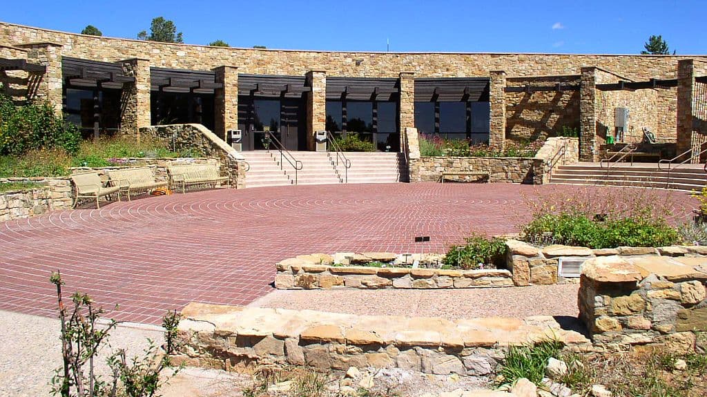
At 27501 Colorado State Highway 184, the Canyons of the Ancients Visitor Center and Museum does the work of a front door for Dolores County. It is the headquarters for Canyons of the Ancients National Monument, a place where almost 4 million artifacts, guided hikes, and trip-planning advice all point visitors toward a larger archaeology corridor that runs through Dolores, Cortez, Mesa Verde, and beyond. Its setting, about 3 miles west of downtown Dolores, 10 miles north of Cortez, and 17 miles from Mesa Verde National Park, makes it part of the county’s day-trip economy as much as part of its heritage landscape.
A first stop that shapes the trip
The center sits at the foot of the San Juan Mountains, but its real value is practical: it tells people where to go before they head deeper into the monument. That matters in a county where access rules, unpaved back roads, and fragile sites can turn a casual stop into a missed turn or a damaged ruin if visitors improvise. By sending people in with maps, exhibits, and federal monument guidance, the museum helps convert curiosity into a safer and more informed visit.
That role also has a local economic edge. A visitor who starts in Dolores is more likely to stop for fuel, food, or a quick errand in town before heading out to the monument loop or on toward Cortez and Mesa Verde. In a landscape where the museum is not an isolated attraction but an orientation hub, the first impression of Dolores County is shaped as much by where people check in as by what they go on to see.
What the museum actually offers
The Bureau of Land Management describes the museum as the premier archaeological museum in Southwest Colorado, and the collection backs up that claim. It curates almost 4 million artifacts from the surrounding area and interprets Ancestral Puebloan, Native American, and historic cultures through exhibits, films, and programs. That makes the center more than a display hall: it is the place where the monument’s story is organized for the public in one stop.
The museum’s identity changed formally in 2018, when the Bureau of Land Management renamed the former Anasazi Heritage Center as the Canyons of the Ancients Visitor Center and Museum. A public ceremony was scheduled in Dolores for April 21 that year, tying the name to the monument itself and making the rebrand part of how the county presents its archaeology corridor.
The center also adapted its public access during the pandemic. Beginning April 1, 2021, visitors could use an online reservation system for self-guided tours. In 2022, the Bureau of Land Management resumed interpretive programs, guided hikes, and curation-program tours starting July 6, with programs scheduled at 2:00 p.m. Thursdays, Fridays, and Saturdays from July through October. Museum tours cost $7, while federal recreation pass holders and visitors under 18 get in free.
The landscape behind the exhibits
The museum sits inside one of the densest archaeological landscapes in the United States. Canyons of the Ancients National Monument covers 176,000 acres of public land, with more than 8,300 documented archaeological sites and an estimated 30,000 more that may still be recorded. Those sites reflect more than 12,000 years of human history, which is why the monument reads less like a single ruin and more like an entire cultural landscape still being studied and protected.
The Bureau of Land Management describes the monument as a living cultural landscape for 26 tribes and pueblos. It also says the Great Sage Plain in this part of southwest Colorado spans more than 1,500 square miles of high, dry plateau carved by canyons. That scale explains why visitors are told to stay on designated trails, avoid disturbing ancient structures, and leave finds in place. The sites are fragile, and the monument’s value depends on keeping them intact.
The 2023 Monument Manager’s Report adds another layer to that stewardship. Staff, tribes, and partners completed a multi-year process to develop new exhibits for the visitor center, and the new self-guided entry experience is designed to help visitors understand why the monument and center exist, along with the educational and recreational opportunities available there. In practice, that means the museum is not just showing objects. It is translating a large, protected landscape into something that residents and travelers can understand and use.
A corridor, not a single stop
The easiest way to see the center’s broader role is to follow the roads it highlights. The monument’s 88-mile scenic drive passes Hovenweep National Monument, Lowry Pueblo National Historic Landmark, and Painted Hand Pueblo, creating a named route through the archaeology corridor rather than a loose collection of sites. For a visitor, that gives the county a clear itinerary. For Dolores County, it means the museum helps direct traffic into a network of places instead of letting each stop compete on its own.
Lowry Pueblo is one of the most useful reference points on that loop. The Bureau of Land Management says it was first excavated in 1931, became a National Historic Landmark in 1967, and preserves a 1,000-year-old ancestral Puebloan site with a 40-room village. Hovenweep National Monument protects six groups of Puebloan village ruins, and the National Park Service describes the terrain there as narrow ravines, steep canyon walls, and flat mesa tops on the Great Sage Plain. Those named sites give the corridor a scale and continuity that makes Dolores County’s heritage legible to outsiders.
The story reaches back even further in the brochure history, which identifies Escalante Pueblo as the first recorded archaeological site in present-day Colorado. The Colorado Bureau of Land Management archaeology program places the center in a broader state network that includes prehistoric camps, Fremont rock art, Ancestral Puebloan masonry pueblos, Ute traditional cultural sites, the Old Spanish National Historic Trail, and historic mines and ranches. That mix shows why the visitor center matters now: it is the place where archaeology, travel, and local identity meet before the road bends back out into the canyons.
Why Dolores County uses this place as its front door
The center works because it does several jobs at once. It orients tourists, protects fragile sites through federal guidance, explains a landscape that spans 176,000 acres, and gives Dolores County a clear entry point for the Four Corners archaeology story. In a county where a single stop can shape where visitors drive, what they see, and how long they stay, the museum is not a side attraction. It is the place that turns a pass-through into an informed visit.
This article was produced by Prism’s automated news system from verified source data, official records, and press releases, then run through automated quality and moderation checks before publishing. The system is built and supervised by the people who set the standards it runs under. Read our full AI policy.
Did this article answer your question?