Rico turns old railroad grade into 4.7-mile river trail
Rico is using an old railroad grade to build a 4.7-mile connector trail, and the big questions now are access, upkeep and whether it pulls people into town.
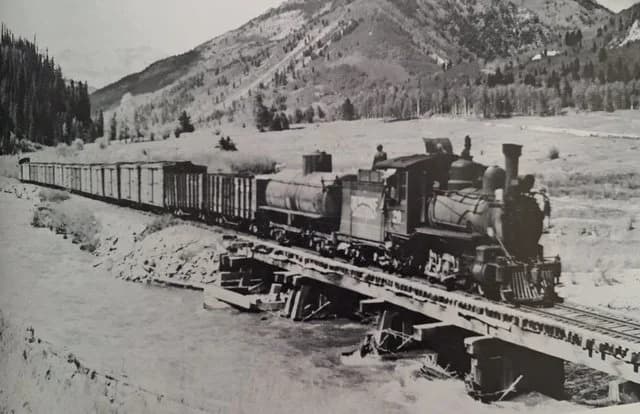
Rico’s old Rio Grande Southern grade is becoming a 4.7-mile river trail that links the town to the Montezuma-Dolores county line. The corridor is meant to move hikers, bikers, snow users and day visitors between Rico, the river valley and the trail system around town.
A trail built on a working piece of local history
The route follows the abandoned Rio Grande Southern railroad grade south from the Town of Rico. Rico was settled in 1879 as a silver mining center in the Pioneer Mining District, then grew in the early 1890s when the Rio Grande Southern Railroad reached Dolores County and made the town part of a rail-and-water-stop network. The railroad was abandoned in 1952, but its corridor is still shaping how Rico thinks about access, land use and its next economy.
The new trail turns that old transportation line into a low-slope recreation route. The grade’s geometry is what makes the project attractive now: it is a natural connector, not a steep backcountry path. The old rail bed offers a practical way to link history with present-day use.
What is already built, and what still matters
Much of the RGS River Trail is already built, which gives the project a real on-the-ground presence instead of a distant concept. The Rico Trails Alliance, the Town of Rico and the U.S. Forest Service are building the trail, and the federal project record shows the Rico Trails Project decision notice and finding of no significant impact were signed on November 17, 2021.
Easements have been secured for the connection from Rico to the existing Rio Grande Southern Trail, which clears one of the biggest practical hurdles for a corridor that crosses National Forest System lands and private property.
Why access points are the real test
The strongest case for the trail is access. The project was intended to improve connectivity to the Colorado Trail via the Circle Trail and to improve the Ryman Creek Trail. The draft environmental analysis also identifies better access around the Ryman Creek Trailhead and the Salt Creek trailhead, which are the kinds of places that determine whether a trail actually changes how people move through Dolores County.
If trail users can reach these trailheads more easily, and if the route keeps some foot and bike traffic off Highway 145, the corridor becomes a safer, gentler spine for local movement and a cleaner entry point for visitors who want to spend time in Rico rather than just drive through it.
Trailheads, parking, signage, and crossings are the difference between a corridor that serves the town and one that mostly serves through-travelers.
A watershed project, not a one-off path
The Rico Trails Alliance formed in spring 2017 with a narrow mission: steward regional trail systems in the upper Dolores watershed and expand non-motorized access for hiking, mountain biking, trail running and fat-tire biking. Since then, volunteers and partners have completed reroutes and improvements on Ryman Creek, the Circle Trail and the Burnett Connector.
In 2024, the alliance broadened its mission to serve the entire upper Dolores River watershed and to champion inclusive, sustainable trail use. The RGS River Trail is part of a wider network strategy that connects town edges, trail systems and river corridor access across the watershed.
The alliance calls the RGS River Trail & Pedestrian Bridge its most ambitious effort yet.
What locals should watch next
Residents and business owners should watch for three things: where the final access points are placed, who is responsible for long-term maintenance, and whether the route actually channels people into downtown Rico.
The maintenance issue is especially important because the trail already sits at the intersection of public land, private property and shared stewardship. The Forest Service review cleared the way for the corridor, but keeping it usable will require regular upkeep, clear responsibility and enough coordination to handle seasonal wear, drainage and snow use.
The trail is designed as a gentle-grade non-motorized route that can support Nordic skiing, fat biking, snowshoeing and handcycling. It gives Rico a four-season asset instead of a summer-only path, which could matter for a small mountain town that wants more consistent foot traffic, not just another warm-weather attraction.
Why the corridor reaches beyond recreation
The trail already carries a local-use history of its own. The draft environmental analysis documents hikers, fishermen and hunters using the corridor before official completion. That means the project is formalizing an existing route as much as creating a new one, which gives it a practical edge over projects that begin with no real user base.
If the access points are handled well, the RGS River Trail could support downtown Rico, strengthen the outdoor economy and preserve the shape of the town’s mining and rail past at the same time.
This article was produced by Prism’s automated news system from verified source data, official records, and press releases, then run through automated quality and moderation checks before publishing. The system is built and supervised by the people who set the standards it runs under. Read our full AI policy.
Did this article answer your question?