USGS map reveals the geology behind Rico's mining past
The Rico quadrangle map shows how geology steered mining, settlement, and access in Dolores County, and why mine country still shapes the landscape today.
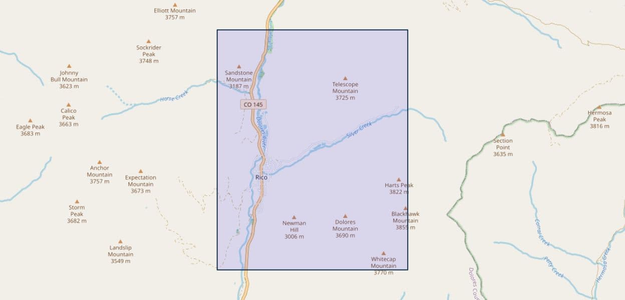
Before you head up the road to Rico, the USGS map explains why the town settled where it did, why miners followed the same mountain corridors, and why old workings still matter for flooding and access. The Rico quadrangle is not just a patch of rock on paper: it is a 236-square-mile window into the terrain at the head of the Dolores River, where ridges, valleys, and mineralized zones helped define one of Dolores County’s most important mountain communities.
Why the Rico quadrangle matters
The Rico quadrangle sits in southwestern Colorado, about 50 miles west of the Continental Divide, in the zone bordering the San Juan Mountains. It spans parts of both Dolores County and Montezuma County, which makes it useful for understanding more than the townsite itself. Its boundaries, 108° to 108° 15' west longitude and 37° 30' to 37° 45' north latitude, frame a mountain landscape that connects Rico to the surrounding headwaters country and to the routes people later used to move through it.
A quadrangle map is a practical tool because it shows the bones of the land: rock units, faults, slopes, drainage patterns, and the structural lines that influence where trails, roads, and old mining routes tend to go. In a place like Rico, those details are not academic. They help explain why some drainages cut where they do, why some ridges carried ore, and why settlement clustered in particular pockets of the mountains instead of spreading evenly across the basin.
How the rocks shaped Rico’s mining story
The town’s mining past starts with geology, not with the mine names. The area’s ore deposits formed where intrusive activity and mineralization worked through the mountain rocks, creating the conditions that drew prospectors into the district. A 1979 USGS open-file report on “Pliocene intrusive rocks and mineralization near Rico, Colorado” identified intrusive rocks in the Rico area and tied them to ore-forming processes, reinforcing the idea that the town’s mining boom grew out of specific geologic events.
That matters because it turns Rico from a generic mining town into a place whose history is written into the ground itself. The rocks helped determine where miners found value, where camps developed, and why the district became a focal point in the high country. For residents and visitors, the same geologic controls still show up in the terrain, from the shape of slopes to the way travel routes thread through passes and drainages.
The historic Rico district in county memory
Rico’s importance in Dolores County goes beyond extraction. A 1953 Colorado Magazine article said Rico was once the county seat of Dolores County and the location of the Pioneer Mining District, which it described as one of the richest of the early carbonate mining fields. That is a reminder that Rico was not simply a camp on the edge of the mountains. It was once a center of local government and a core part of the county’s economic identity.
A 1968 New Mexico Geological Society guidebook article described Rico as having a century of historic adventures in mining. That language fits the broader pattern visible in the quadrangle map: a place where geology encouraged repeated waves of prospecting, development, and reworking of old ground. The map gives the town’s story geographic shape, showing how a mountain district can become both a settlement and a mining landscape at the same time.
What the map shows for roads, hikes, and day-to-day access
For people moving through the Rico area now, the same geologic framework still affects where it is easiest to travel. Ridges, valleys, and altered ground steer roads and trail access, while old mining terrain can create steep cuts, unstable slopes, and places where the landscape changes quickly over short distances. In the San Juan border country, that means the map is useful not only to geologists but also to anyone planning to drive, hike, or explore around Rico’s back roads and headwaters routes.
The map also helps explain why some places feel more open and accessible while others are hemmed in by steep walls or narrow drainages. In mountain communities, those differences shape daily movement as much as recreation. A road corridor that looks straightforward on a highway map can make more sense once you see the underlying structure that guided the landscape in the first place.
Why mine flooding still belongs in the story
Rico’s mining past did not end when the mines closed. The Colorado Geological Survey published an open-file report on identification and remediation of a mine flooding problem in Rico, and that work specifically discusses geology, mining activities, the Atlantic Cable Mine, the Van Winkle Mine, the Shamrock Mine, and the hydrology of Silver Creek. That combination of subjects shows how old workings continue to interact with water and terrain long after the boom years ended.
For land use and hazard awareness, this is the part of the story that still reaches into the present. Mine flooding can affect drainage, groundwater movement, and the stability of disturbed ground. Silver Creek’s hydrology ties the problem to the broader watershed, which means the consequences are not confined to one adit or one mine site. The same district that helped build Rico also left a legacy that still matters for resource management and safety.
Reading the landscape with a local lens
The Rico quadrangle map is most useful when you treat it as a guide to why the county looks and works the way it does. It shows why Rico emerged where the mountains allowed mineralization, why travel corridors followed certain terrain, and why the town became a historic anchor in Dolores County’s mining identity. It also helps explain why old mines, flooded workings, and water movement remain part of the conversation around Silver Creek and the surrounding high country.
For anyone who lives in or travels through Dolores County, the value is practical. The map helps make sense of the slopes, drainages, and access routes around Rico, and it connects those features to a century and more of mining history. In a landscape like this, geology is not background. It is the reason the town sits where it does and the reason its mining-era footprint still shapes the mountains around it.
This article was produced by Prism’s automated news system from verified source data, official records, and press releases, then run through automated quality and moderation checks before publishing. The system is built and supervised by the people who set the standards it runs under. Read our full AI policy.
Did this article answer your question?