Lost Coast’s King Range offers rugged hikes and wild shoreline
The Lost Coast looks inviting until tides, steep ridges and limited access turn the King Range into a test of timing, supplies and self-reliance.

Highway 1 bends inland because the King Range’s terrain is too steep for a coastal road, leaving behind a shoreline where King Peak rises 4,088 feet just three miles from the Pacific and where a beautiful hike can turn into a serious logistics problem fast. In Humboldt County, the King Range National Conservation Area is 68,000 acres of exposed coast, high ridges and tide-sensitive trails that demand planning before anyone laces up a boot.
Why the King Range feels remote even before you start walking
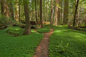
The King Range National Conservation Area stretches across 35 miles of California’s north coast and holds the nation’s first National Conservation Area, designated in 1970. Its backcountry includes 42,694 acres of wilderness. Trails move from beach walks to steep upland routes, many are strenuous, many are minimally signed, and some are overgrown enough to punish a late start or a sloppy route plan.
The same geography keeps access limited, so visitors expecting a simple scenic drive or an easy day hike often have to revise their plans.
Permits, tides and the timing that makes or breaks a trip
Overnight travel in the King Range Wilderness and Backcountry Management Zone requires a wilderness permit reserved through Recreation.gov. Day-use visitors do not need one, but that does not make the area simple to navigate. The Bureau of Land Management runs a daily quota system for overnight permits, with 60 permits per day from May 15 through September 15 and 30 permits per day from September 16 through May 14.
Tides are the other hard constraint. Sections of the Lost Coast Trail become impassable when tides are above three feet, which turns route planning into a matter of clock-watching rather than just mileage. Winter raises the stakes further. Storms, heavy surf, landslides and dangerous stream crossings can make travel impossible even when the tide chart looks favorable. Visitors need to track the calendar, tide table and weather forecast in equal measure.

A few basics shape almost every safe trip here:
- Reserve overnight wilderness permits well in advance through the permit system.
- Check tide conditions for the specific Lost Coast Trail sections you plan to use.
- Expect steep, minimally signed and sometimes overgrown trails.
- Plan as if conditions can change the route on short notice.
A popular place that still has to be managed like wilderness
It receives an average of 135,000 visits a year and issues about 12,000 wilderness backpacking permits annually. The BLM’s 2023 manager report put visitation at 136,586, a figure that included overnight wilderness use, day use at Shelter Cove and Black Sands Beach, and dispersed activities such as hunting and backroad travel. A 2021 manager report recorded an approximate 1,100 percent increase in visitor use between 2007 and 2021, alongside a 95 percent overall visitor satisfaction rating.
Recreation fee dollars help pay for services that are easy to miss when the country looks untouched, including vault toilet pumping, landscaping, trash collection and routine maintenance.
The Lost Coast is also a living cultural landscape
The Lost Coast sits within a 60-mile stretch of wilderness made up of Sinkyone Wilderness State Park and the King Range National Conservation Area. Sinkyone Indians lived on this coast for thousands of years before Europeans arrived. The King Range is within the homeland of the Dene-speaking Mattole and Sinkyone peoples, where ceremonial use and the traditional gathering of plants for food, regalia and basketry regularly take place.
The area lies near the Mendocino Triple Junction, where the Pacific, North American and Gorda plates meet. That collision zone helps create the folding, faulting, black-sand beaches and dramatic relief that make the coast visually distinctive and physically demanding. The same forces shaped the shoreline and help explain why the region never became a conventional development corridor.
More than a hiking destination
The King Range is managed as a landscape with overlapping uses, not a single-purpose preserve. It supports grazing through five permitted allotments, and it also serves wildlife viewing, horseback riding, mushroom collecting, mountain biking, hunting, surfing, camping and ocean fishing. The lower Mattole River adds another access point for anglers seeking steelhead, while Shelter Cove and Black Sands Beach bring day users to the shoreline.
The King Range Alliance, formed in 2014, works with Friends of the Lost Coast, the Mattole Restoration Council, the Mattole Salmon Group and Sanctuary Forest on coastal prairie and native grassland restoration, estuary restoration at the mouth of the Mattole River and streamflow enhancement.
This article was produced by Prism’s automated news system from verified source data, official records, and press releases, then run through automated quality and moderation checks before publishing. The system is built and supervised by the people who set the standards it runs under. Read our full AI policy.
Did this article answer your question?