Kokee trails poster maps easy walks and rugged canyon hikes
The Kōkee/Waimea Canyon poster helps hikers sort easy loops from steep canyon descents, then check weather, parking, and trailheads before driving Highway 550.
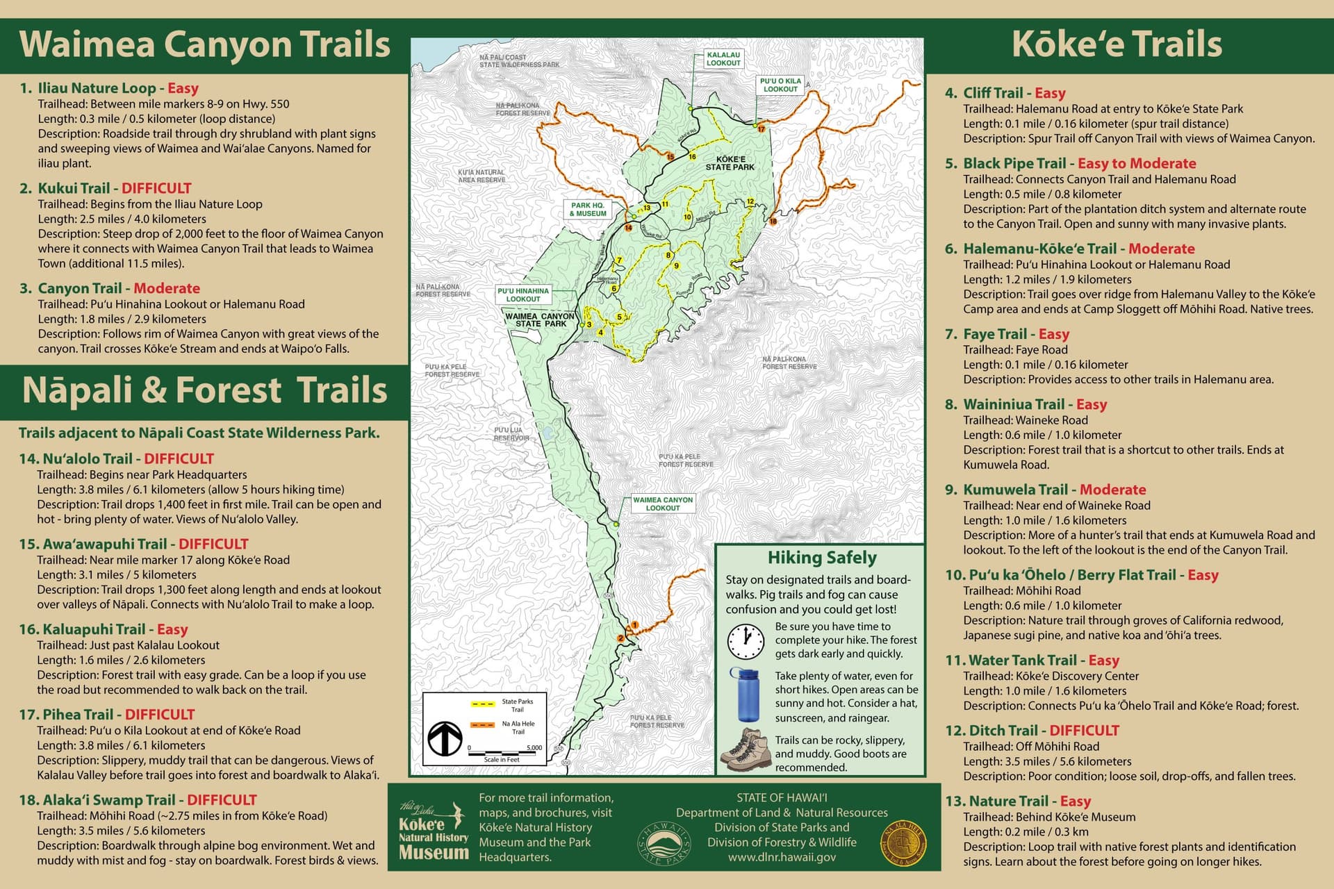
The official Kōkee/Waimea Canyon trails poster puts the Iliau Nature Loop and the Kukui Trail on the same page, with their difficulty, distance, and access points laid out side by side. That matters in a landscape where a short roadside walk and a steep canyon descent can start from the same stretch of Highway 550.
Why the poster matters before you leave home
Kōkee is not just one viewpoint or one famous trail. The poster shows a network that includes short interpretive walks, steep descent routes, and longer backcountry connections, so the first job is matching the route to the day you want to have. Kōkee’s uplands were first recognized as a forest preserve at Puu ka Pele in 1907. Nearly a quarter of the mountains and Waimea Canyon have since been set aside as parks, forest reserves, or wilderness preserves, Hui o Laka says, to protect native flora and fauna and the island’s watershed.
The trails sit inside a protected landscape shaped by conservation, watershed protection, and visitor access, so the details on the poster help you avoid turning a scenic drive on Highway 550 into a guess.
Iliau Nature Loop: the easy roadside choice
The Iliau Nature Loop is the clearest low-commitment option on the poster. It is labeled easy, starts between mile markers 8 and 9 on Highway 550, and runs 0.3 mile, or 0.5 kilometer, as a loop.
The route passes through dry shrubland, includes plant signs, and opens onto views of Waimea and Waialeale Canyons. The trail is named for the iliau plant, which gives the loop a natural-history frame that makes it useful for families, first-time visitors, and anyone who wants canyon scenery without committing to a longer hike.
Because the trailhead is roadside, it also works well as a quick decision point. If the parking area is crowded or the weather shifts, the loop is short enough to fit into a flexible day, and the poster makes that obvious before you start climbing into Kōkee.
Kukui Trail: a steep canyon descent, not a casual outing
The Kukui Trail is the opposite end of the scale. The poster marks it as difficult, and it begins from the Iliau Nature Loop area. From there, it drops steeply about 2,000 feet to the floor of Waimea Canyon, covering 2.5 miles, or 4.0 kilometers, on the poster.
The Kukui Trail is also a connector, not just a one-way scenic drop. It links with the Waimea Canyon Trail, which continues to Waimea Town for another 11.5 miles. That makes route planning more serious: once you start down, you are dealing with a demanding descent and the possibility of a much longer connection if you are not turning back at the canyon floor.
An older trail handout lists Kukui as a scenic but steep trail into Waimea Canyon with the same 2,000-foot elevation drop and a total length of 6.0 miles, or 9.5 kilometers. The difference appears to turn on whether the route description covers the canyon descent alone or the larger through-hike connection.
What to verify with state park officials
The Hawaii Department of Land and Natural Resources, Division of State Parks, advises visitors to monitor weather reports and ocean conditions before they visit. Even for inland hikes, weather affects traction, visibility, pacing, and the ability to move safely on steep ground.
The same state park notices warn visitors to Waimea Canyon and Kōkee state parks to expect delays and limited parking. On Highway 550, access can shape whether a hike is worth starting at all. Before driving up, check the official poster against current park guidance so you know the trailhead, the length, the difficulty, and whether your timing fits the day’s access conditions.
For residents and visitors alike, the safest approach is simple: use the poster to choose the route, confirm conditions with state park information, and then decide whether the road, the parking, and the weather all match the hike you want.
This article was produced by Prism’s automated news system from verified source data, official records, and press releases, then run through automated quality and moderation checks before publishing. The system is built and supervised by the people who set the standards it runs under. Read our full AI policy.
Did this article answer your question?