How Menominee County maps land, rivers and communities online
Menominee County’s online maps do more than show roads: they help settle parcel questions, speed fire response and keep remote addresses readable across 360 square miles.

Menominee County spans about 234,355 acres, or 360 square miles, including roughly 223,500 acres of heavily forested land about 45 miles northwest of Green Bay. In a county shaped by the Menominee Indian Reservation, the Township of Menominee, four rivers and a scattered settlement pattern, a home, a fire number and a parcel line can sit deep in the woods and far from the nearest paved road. The online map system is part of how daily life works.
Where to look first for a parcel boundary
If the question is “where does this property start and stop,” the Menominee County Land Information Office is the fastest place to begin. The office was created in 1998 through Wisconsin Land Information Program grant funding, and its mission is to provide accessible, complete, timely and as accurate as possible land information to government, utilities and the public. Its parcel map application, built with ArcGIS Online, lets users pan, zoom, search by parcel attributes and query parcels on screen.
That tool is useful for quick reference because it shows assessed land value, assessed improvements, total assessed value, property class, estimated fair market value, tax, address, parcel ID and school district. It is the right screen to open when you need to compare a parcel number on a deed, check a mailing address or understand how a piece of land is classified for tax purposes.
GIS parcel maps are for informational purposes only and are not evidence of title. If a boundary dispute matters, or if you need a legal parcel description for a sale, estate issue or easement, the county directs users toward legal representation or survey advice. The practical rule is simple: use the map for orientation, then use a survey or legal review when the line itself is the issue.
What to use when fire access or emergency response is the problem
For a rural county like this one, a correct fire number can matter as much as a street name in a city. Menominee County offers a fire number sign order form, and it also makes fire number and road directories, including parcel ownership, available through the Land Information Office for $20. Those directories are built for people who need to know who owns a parcel, where a road leads, and how responders will find the property from the nearest public route.
The Town of Menominee Volunteer Fire Department serves the Menominee County and Reservation area and more than 4,500 residents. The department operates two stations, one in Keshena and one in Neopit, and reported 219 calls in 2021. In a landscape with long driveways, forest cover and seasonal traffic, getting a fire number right can shorten the gap between a call and a truck reaching the scene.
Menominee County Emergency Management develops all-hazard plans, conducts exercises, provides training and responds to disasters. That makes the fire number system and the directory work part of a larger safety net, one that includes planning for storms, road closures and other disruptions that can isolate homes and businesses quickly.
How to navigate remote roads, lake country and winter travel
When the question is not ownership or emergency access but “how do I get there,” Menominee County gives residents and visitors several map products in one place. The county provides a downloadable county map PDF, a lake area road map PDF and a snowmobile trail map PDF. Those are the tools to save before a trip into the woods, a day on the trails or a drive toward a lake property that does not sit on an obvious grid.
The county contains four main communities, Keshena, Neopit, Zoar and South Branch, and four rivers: the Evergreen, Oconto, Red and Wolf. The land base includes the largest single tract of virgin timberland in Wisconsin. In that setting, roads do not behave like city blocks. They bend around forest, water and reservation land, which is why the county’s map set is designed for everyday routing, not just archival filing.
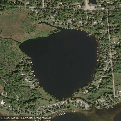
Legend Lake is a spring-fed lake over six miles long with 47.5 miles of shoreline and is a major recreational area with both seasonal and permanent homes. A lake of that size needs more than a general atlas view. The lake area road map helps visitors find access points and residents confirm where roads and homes connect to the shoreline. The snowmobile trail map does the same in winter, when trail routes become travel routes and a wrong turn can carry you deep into the woods.
Why the county treats land information as core public infrastructure
Menominee County’s mapping system sits at the center of a larger land-use framework. All lands within its jurisdiction, whether taxable or fee lands, are zoned and governed by its zoning ordinance, adopted April 15, 1999. It also adopted a new shoreland protection ordinance after state law changes, which reflects how closely land, water and development are linked in a county built around forests and rivers.
This approach has been steady rather than improvised. The Menominee Town and County comprehensive plan, adopted in 2015, is a 20-year smart-growth plan developed with the East Central Wisconsin Regional Planning Commission. The county’s land and water resource management plan was approved by the Wisconsin Land and Water Conservation Board in October 2017 and by the county board in November 2017 for 2018 to 2027 implementation.
The U.S. Census Bureau lists Menominee County’s 2020 population at 4,255, and its 2020 to 2024 estimates say 78.5 percent of residents identified as American Indian and Alaska Native alone. The county seat, Keshena, sits on the Menominee Indian Reservation.
A county shaped by treaty, restoration and shared boundaries
The land system also reflects a history that predates the county itself. The Menominee treaty of 1854 was signed at the Falls of Wolf River on May 12, 1854. Federal recognition for the Menominee Indian Tribe of Wisconsin was restored on December 22, 1973, when the Menominee Restoration Act repealed the 1954 termination act. The county is unique because it shares coterminous boundaries with the one Township of Menominee as well as the Menominee Indian Reservation.
This article was produced by Prism’s automated news system from verified source data, official records, and press releases, then run through automated quality and moderation checks before publishing. The system is built and supervised by the people who set the standards it runs under. Read our full AI policy.
Know something we missed? Have a correction or additional information?
Submit a Tip