Kentucky marker ties Owsley County to Governor William Owsley home
A marker north of Booneville links Owsley County to Governor William Owsley, turning the county name into a visible trace of antebellum Kentucky politics.
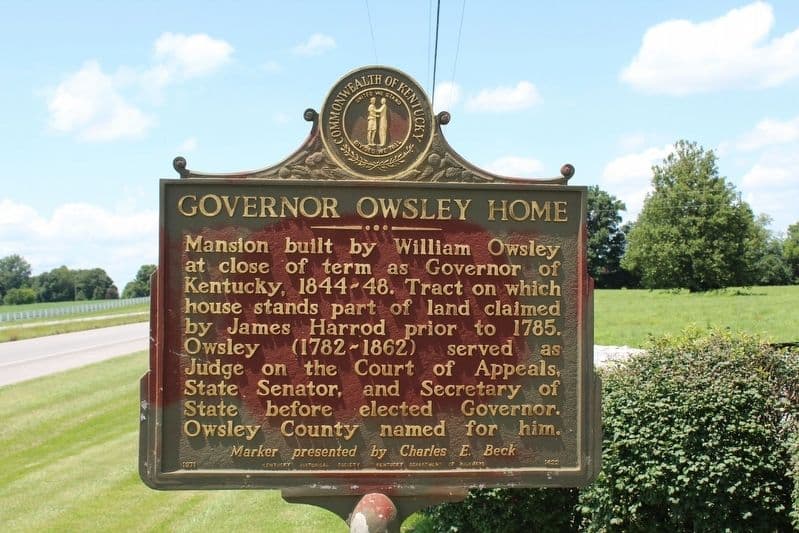
Owsley County carries the name of a real governor, and a Kentucky Historical Society marker along U.S. 127 north of Booneville puts that fact back on the landscape. The sign turns a county label into a place-based story: who William Owsley was, why a county founded in 1843 chose his name, and what Booneville says about the politics and memory that shaped eastern Kentucky.
Why the marker matters in Booneville
The Governor Owsley Home marker sits about 1.5 miles north of Booneville on U.S. 127, which makes it more than a roadside label. It is a public reminder that county identity in Kentucky often began as a political decision, then hardened into geography, road signs, and courthouse references. In Owsley County, that decision still follows residents into daily life every time the county name appears on mail, maps, or school and government records.
The marker is also part of a much larger state effort. The Kentucky Historical Society says its historical marker program has operated since 1949 and has installed more than 2,400 markers across the Commonwealth with community partners. That puts the Booneville marker inside a long-running public-history system, one meant to explain local places in plain view rather than lock their stories away in archives.
Who William Owsley was
William Owsley was born in Virginia on March 24, 1782, and died December 9, 1862. He came to Kentucky with his family in 1783 and settled in Lincoln County, where he attended common schools before working as a teacher, deputy sheriff, and surveyor. His path into law and politics reflected the kind of upward mobility that shaped many early Kentucky leaders, but his influence came from public office rather than from Booneville itself.
Owsley served in the Kentucky House of Representatives starting in 1809, sat on the Kentucky Court of Appeals from 1812 to 1828, and later became Kentucky secretary of state before becoming governor. He was Kentucky’s 16th governor, a Whig, and served from September 4, 1844, to September 6, 1848. A Kentucky Historical Society marker at Pleasant Retreat in Lancaster identifies that property as his home and names his public service in the House, Senate, Court of Appeals, and as Kentucky secretary of state and governor. He was married to Elizabeth Gill and had six children.
That background matters because Owsley County was not named for a distant national figure or a battlefield hero. It was named for a man who had already helped shape state politics and institutions. The county name is therefore a political artifact, a record of whom Kentucky chose to honor in the 1840s and why that mattered at the time.
How the county and Booneville took shape together
Owsley County was founded in 1843 and organized on January 23, 1843, from parts of Clay, Estill, and Breathitt counties. That timing matters because the county and its seat were being created in the same narrow stretch of years, when settlement, land donations, and state recognition were all moving together. Naming the county after William Owsley placed a sitting political figure into the geography of a brand-new county.
Booneville, the county seat, was incorporated in 1846 and had earlier been known as Boones Station and Moores Station. The Owsley County Historical Society says Booneville is on the South Fork of the Kentucky River at KY 11 and KY 30, and that Daniel Boone had once camped in the area. Elias Moore donated land for the new county seat in 1843, the Owsley Court House and post office opened in 1844, and the community was renamed Booneville in 1846.
Those details make the county’s story unusually compact. The county was organized in 1843, the courthouse and post office were operating by 1844, and the seat had a new name by 1846. That sequence left a paper trail and a place trail at the same time, which is part of why the marker still reads clearly today.
What the name reveals about power and memory
The marker also shows how antebellum politics shaped what Kentucky chose to remember. William Owsley’s rise passed through the legislature, the court system, the executive branch, and the secretary of state’s office. That breadth made him an obvious figure for commemoration in a period when counties, towns, and public buildings often carried the names of men who embodied state power.
That choice can create both pride and discomfort in the present. Pride comes from having a county name tied to a figure who was central to Kentucky’s political life. Discomfort comes from the same place, because the name preserves the authority of a pre-Civil War political order that locals did not choose personally but still inherit every day. The roadside marker does not settle that tension; it makes it visible.
For Booneville and the rest of Owsley County, that visibility is the point. The county seat on the South Fork of the Kentucky River, the former names Boones Station and Moores Station, the courthouse-era post office, and the marker north of town all tell the same story in different forms. Owsley County is not just named after a governor. It is tied to a specific era when Kentucky’s public leaders were written into place, and that history still stands beside U.S. 127 for anyone passing through.
How to read the site today
A visit to the Governor Owsley Home marker is easiest to understand if you read it with the county seat in mind. Booneville sits at the junction of KY 11 and KY 30, and the marker north of town gives the county name a physical anchor just beyond the main center of local life. The site is part of a broader network of Kentucky historical markers, but in Owsley County it does more than explain one man’s biography.
- It connects the county name to William Owsley’s career and dates.
- It places Booneville inside the larger story of 1843 county formation.
- It links the courthouse community to the land donation, post office, and incorporation that followed.
- It shows how Kentucky uses markers to keep local political memory in public view.
That is what makes the sign durable. It does not only identify a home site. It explains why a county in eastern Kentucky still carries the name of a Whig governor born in Virginia in 1782, and why Booneville remains central to how that history is understood.
This article was produced by Prism’s automated news system from verified source data, official records, and press releases, then run through automated quality and moderation checks before publishing. The system is built and supervised by the people who set the standards it runs under. Read our full AI policy.
Did this article answer your question?