Popham Colony marks English settlement first at Maine's Kennebec River
Popham Colony gives Phippsburg a rare on-site window into 1607, with artifacts, a model recreation, and the story of Maine’s first English colonial push. Its legacy now includes heritage tourism and a fuller accounting of Wabanaki history.
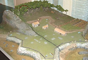
The mouth of the Kennebec River holds one of Sagadahoc County’s most consequential small places. At Phippsburg, the Popham Colony site marks the English settlement first planted in Maine in 1607, and what remains today is tangible enough for visitors to stand beside: a model recreation, a gravel parking area, a large artifact collection, and the landscape around Sabino Head and Popham Beach.
That physical footprint is modest, but the story tied to it is not. Popham was the first organized English attempt to establish a colony on the shores of New England, and it is one of the clearest local reminders that the county’s coastal heritage reaches far beyond scenic shoreline.

What visitors can actually see now
The site is not a reconstructed village or a fully built historic park. Maine State Parks describes it as a model recreation, a gravel parking lot, and artifacts that help mark where the colony stood. In practical terms, that makes the experience more interpretive than immersive: you are looking across a real landscape where a colony once stood, not walking through a preserved streetscape.
That limited footprint still matters for local identity and tourism because it gives Sagadahoc County a rare chance to connect place, memory, and archaeology. The site’s listing in the National Register of Historic Places, with a significant year of 1607, places it in the formal record of the nation’s early colonial story, while the setting at Popham Beach State Park and Sabino Head gives residents and visitors a place to visit without needing a museum ticket.
Why Popham stands out in Maine’s history
Popham Colony was planted at the mouth of the Kennebec River in the summer of 1607 and lasted a little more than a year before the English abandoned it in the fall of 1608. That short life is part of why it is easy to overlook, but it is also why the site carries so much symbolic weight. It represents an organized English colonial attempt that arrived early, took aim at the coast of what became New England, and then disappeared before it could harden into a permanent settlement.
The colony’s first year also produced one of its most memorable achievements: the construction of the Virginia, a 30-ton pinnace described by Maine State Parks as the first ocean-going ship built on the continent. Maine’s state history materials say the Virginia ranged the Maine coast in 1608 and 1609 and crossed the Atlantic at least twice, which gives the Popham story an unusually concrete maritime dimension. In a county shaped by river and shore, that detail connects the colony to the working geography people still recognize along the Kennebec today.
The people behind the colony
The expedition is commonly described as involving about 120 men and boys sailing in two ships, the Gift of God and the Mary and John. George Popham led the colony at first, but after he died in February 1608, Raleigh Gilbert took over. The settlement was abandoned in October 1608, making its life span brief but densely packed with colonial ambition, shipbuilding, and survival on a contested coast.
Those names matter because they keep the story anchored in specific people rather than broad legend. Sir John Popham’s name survives in the colony’s title, while George Popham and Raleigh Gilbert represent the leadership of a venture that was never simply a footnote. It was tied to the Virginia Company of Plymouth and the broader English push to compete in the Atlantic world at a moment of rivalry with Spain and France.
Why the colony failed, and why that matters now
Popham did not fail only because of weather, distance, or time. National Museum of the American Indian materials say Abenaki leaders boycotted trade with the colony, a critical factor in its collapse. That detail changes how the settlement should be understood in the present: not as an isolated English experiment, but as a contact-zone shaped by Indigenous decision-making, resistance, diplomacy, and control over trade.
The site also sits within a much longer Wabanaki history. Archaeological work at Sabino Head and Popham Beach from 1994 to 2013 produced evidence of both the colony and earlier seasonal occupation by Wabanaki people stretching back thousands of years. That makes the site more than a colonial landmark. It is a place where English arrival entered a much older Indigenous landscape, and any honest interpretation has to hold both histories at once.
Rediscovery changed the story
For nearly 400 years, the colony’s exact footprint stayed buried. Maine Memory Network notes that archaeologist Jeffrey Brain uncovered the first construction feature in 1994, reopening a site that had been out of view since 1608. Later identification placed the colony at Sabino Head and Popham Beach, turning a half-remembered episode into a documented archaeological site.
That rediscovery gave Sagadahoc County something important for present-day heritage tourism: not just a story, but a place where the story was physically recovered. The Fort St. George and Popham digs, associated with Brain and later work through 2013, helped establish the site’s location and its connection to earlier Wabanaki seasonal use. For visitors, that means the landscape carries layered meaning rather than a single historic date.
How to experience the site on the ground
A visit works best when you treat it as a landscape stop rather than a long museum day. The most visible markers are the model recreation, the gravel parking area, and the artifacts associated with the colony. In a 2020 description of the site, the ground-level presence was noted as a grassy field with plaques, a flagpole, and a commemorative boulder, which is still a useful way to picture the modest scale of what remains.
- the mouth of the Kennebec River, where the colony was planted in 1607
- Sabino Head and Popham Beach, where later archaeology pinned down the site
- the interpretive markers and artifacts that connect the open ground to the excavation record
- the broader coastline, which helps explain why a shipbuilding outpost belonged here
A visit can be centered on a few simple points of attention:
That combination makes the site useful to residents who want to understand their county’s foundations and to visitors who want more than a scenic stop. It also keeps the focus where it belongs: on a place where English colonial ambition, Indigenous presence, and modern archaeology meet in one of Maine’s smallest but most revealing historic landscapes.
This article was produced by Prism’s automated news system from verified source data, official records, and press releases, then run through automated quality and moderation checks before publishing. The system is built and supervised by the people who set the standards it runs under. Read our full AI policy.
Did this article answer your question?