Highest summer tides flood San Francisco waterfront, disrupt traffic
Water spilled across the Embarcadero by Pier 14 as San Francisco hit a record summer tide, slowing walkers and cyclists and warning of more flooding through Thursday.
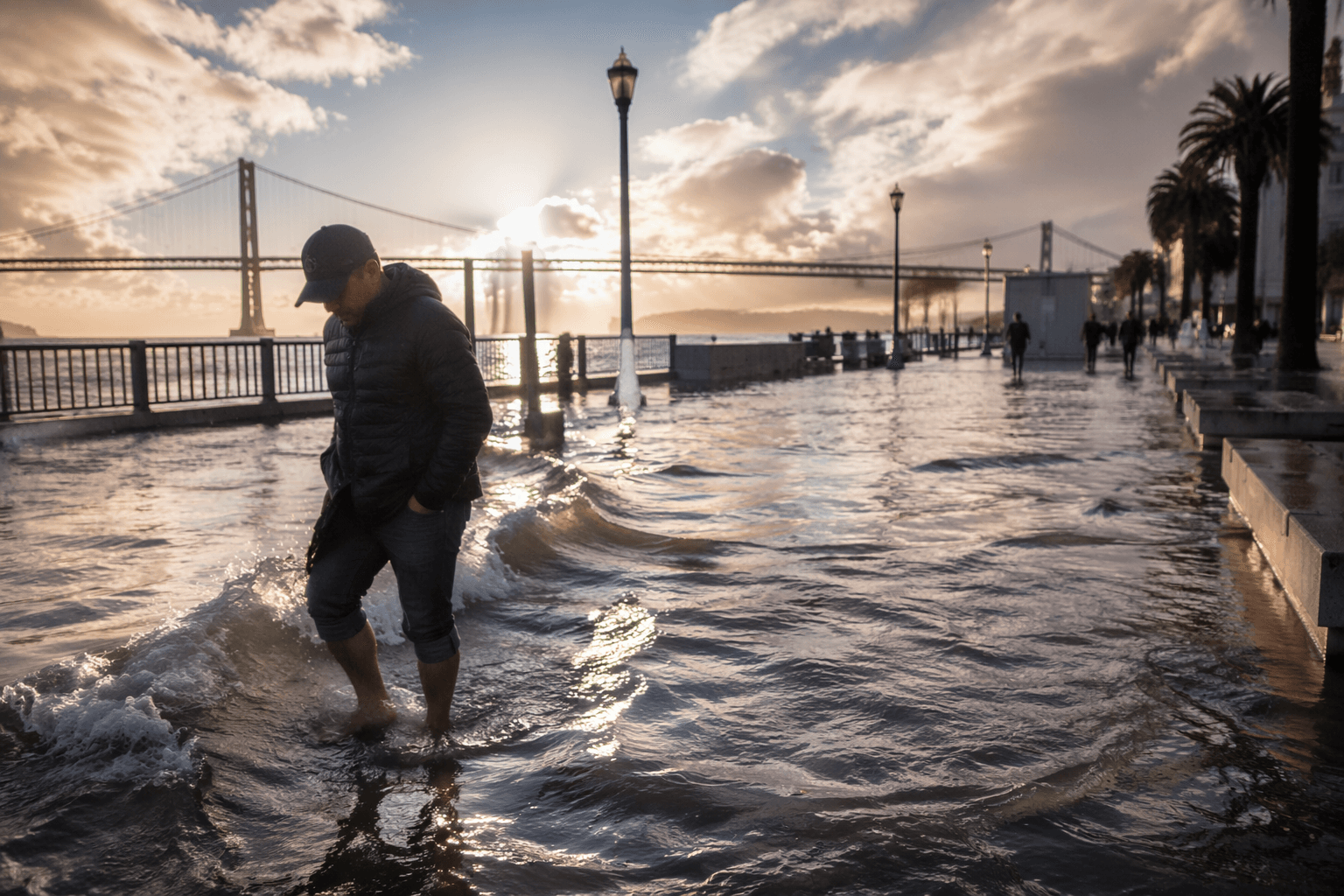
Water spread across the sidewalk and into the street near Pier 14 on the Embarcadero, turning one of San Francisco’s busiest waterfront stretches into a slippery crossing for pedestrians and cyclists. The flooding came during the Bay Area’s highest summer tides on record, with San Francisco’s peak forecast around 1.8 feet above normal and later updates putting it near 1.9 feet above normal.
At the height of the tide, bicyclists were seen riding through overflowing water by Pier 14, a vivid sign of how quickly a bright waterfront afternoon could become a public-safety problem. The National Weather Service said up to 2 feet of inundation was possible in low-lying shoreline areas around San Francisco Bay and San Pablo Bay, and that flooding could continue in exposed coastal and bayshore spots through Thursday.

The threat was not tied to a storm system. Forecasters described it as minor coastal flooding driven by higher-than-normal high tides, layered with hazardous beach conditions along the Pacific Coast. The weather service warned that long-period south-southwest swell continued to produce sneaker waves and strong rip currents, and told people to stay back from the water’s edge and off jetties and piers. A beach hazards statement for the Pacific Coast ran through early Sunday morning.
The tide gauge in San Francisco reached about 7.81 feet late Sunday, described as the highest summer-season reading on record. That reading helped explain why shoreline access became so fraught so quickly, even without heavy rain. The pattern also stretched beyond the city limits: Marin County officials closed several roads after localized flooding early Monday, and forecasters said isolated road and parking lot closures were possible along the Marin County shoreline and in coastal Sonoma County.
For San Francisco, the immediate problem was the Embarcadero. But the larger issue is whether the city’s waterfront planning is keeping pace with a hazard that is no longer rare or seasonal in any meaningful way. Climate scientists expect coastal flooding to worsen this fall and winter, especially if El Niño conditions strengthen, making future extreme tides a recurring test for streets, sidewalks and shoreline access from Pier 14 to the rest of the bayfront.
This article was produced by Prism’s automated news system from verified source data, official records, and press releases, then run through automated quality and moderation checks before publishing. The system is built and supervised by the people who set the standards it runs under. Read our full AI policy.
Did this article answer your question?