Mesabi Trail connects St. Louis County towns, recreation and local stops
The Mesabi Trail is built town by town, linking St. Louis County riders to meals, museums and overnight stops from Biwabik to Ely. The route’s unfinished stretches still shape how usable it feels day to day.
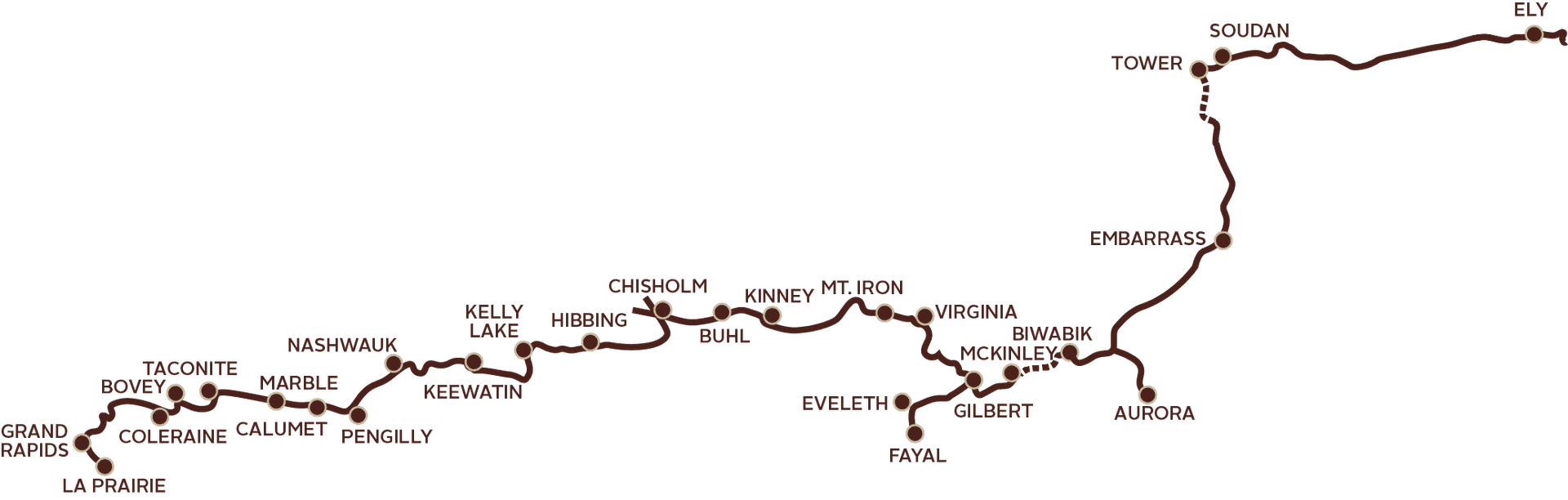
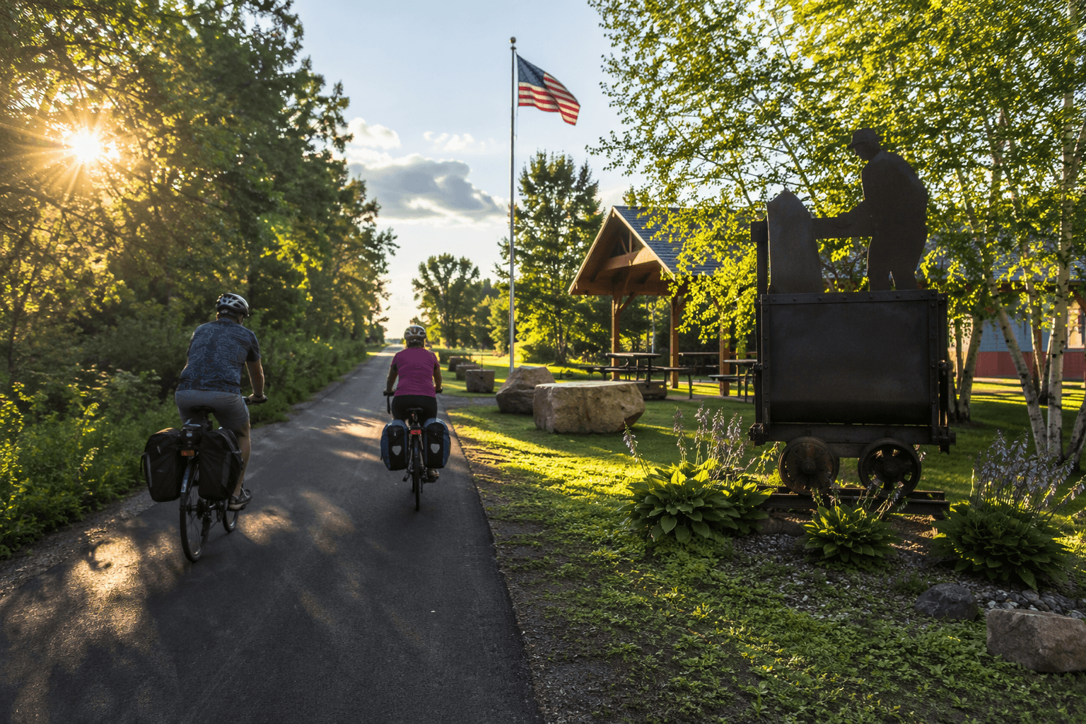
The Mesabi Trail works best when you think of it less as a strip of pavement and more as a chain of places. Its town pages and maps are organized around communities such as Biwabik, Ely, Gilbert and Laurentian, which is a clue to how people actually use it: one ride becomes a stop for food, a museum visit, or a night away in another town.
Trail towns, not just trail miles
The trail’s own map and planning pages frame the route around community stops, not just distance markers. That matters in St. Louis County, where the trail passes through places with distinct identities and different reasons to stop, whether that is downtown Biwabik, the Ely gateway to the Boundary Waters region, or Gilbert and Laurentian, which reflect the Iron Range’s rail-and-road landscape.
A 2023 Mesabi Trail map lists communities and destinations along the corridor including Grand Rapids, Hibbing, Virginia, Eveleth, Gilbert, Biwabik, Tower, Ely and Babbitt. The same map also marks trailheads, tourist information, future construction areas and nearby attractions, showing that the trail is designed as a network of connections rather than a single point-to-point ride.
That town-based design is what makes the trail useful for different kinds of trips. A half-day cyclist can pick one community as a start and finish point, while a family can use the same route to link a paved ride with a downtown meal or a stop at a local attraction. For locals, the value is practical: the trail functions as a way to move between communities without feeling like a separate outing built only for recreation.
How a ride turns into a day out
The 2023 map shows why the Mesabi Trail is more than a scenic path. It ties riders to places such as the Minnesota Discovery Center, Redhead Bike Park, the Greyhound Bus Museum, the Museum of Mining, Fortune Bay, the Bois Forte Heritage Museum and RV Park, and Sherwood Forest Campground. Those stops turn the trail into an itinerary: a morning ride, lunch in town, an afternoon museum visit, and, for some travelers, an overnight stay.
Ely stands out because it offers more than a trail endpoint. It can draw visitors who want both a bike ride and access to the Boundary Waters region, which gives the northern end of the trail a different kind of pull than a simple out-and-back route. Biwabik and Gilbert offer their own Iron Range character, and that variety is part of why the trail feels like a connector between communities rather than a recreational asset floating above them.
The trail also shows up in the way people plan their stay. Campgrounds and tourist-information stops make it easier to stretch one outing into a longer visit, especially if riders are traveling between towns rather than looping near home. That’s the difference between a path you pass through and a corridor you actually use.
What the trail is built for, and what it is not
The Mesabi Trail’s published materials describe it as one of the longest paved bike trails in Minnesota, and other references put it at 132 miles from Grand Rapids to Ely. The city of Keewatin says the trail links 28 communities across the Iron Range and is used by hikers, bikers, joggers and inline skaters. That broad user mix helps explain why the trail matters to more than cyclists alone.
The rules also shape how usable the trail feels. A 2024 map says the trail is non-motorized except for snowmobiles where designated, and that electric-assist bicycles are allowed. A 2026 map adds that a wheel pass is required for ages 18 and older using a bicycle, inline skates or another non-motorized wheeled device.
Those details matter because they define who can use the route and in what season. They also help explain why the trail’s identity is part recreation path and part managed corridor, with clear boundaries around what belongs there and what does not.
- The trail’s planning tools include trail maps, access points and campground pages.
- The contact office is Trail Central at 111 Station 44 Road in Eveleth.
- Riders can reach it directly at 218-744-1388 or through the toll-free line at 1-877-637-2241.
The missing links still shape the experience
The trail is not a finished ribbon from end to end. A Wikipedia search result says that as of 2022, two sections remained to be completed: McKinley to Biwabik and the seven miles south of Tower. Those gaps matter because continuity is what lets the Mesabi Trail function as a community connector instead of a series of disconnected segments.
A March 26, 2026 construction update added another piece to that picture. It said the Aurora to Hoyt Lakes project was still in engineering, tree clearing was in progress, and State Aid approval was still needed before the project could be advertised. For riders, that means the trail remains a living project, with some stretches still being shaped by design and construction rather than fully settled as finished pavement.
That is where usability becomes a local issue. A trail can look impressive on a map, but if a segment is unfinished or under construction, the practical question is whether a rider can comfortably turn one outing into a town stop, a meal, and a return trip without losing continuity.
Why the trail has broader reach
The Mesabi Trail’s community-centered model has drawn attention beyond St. Louis County. TrailLink lists 32 reviews for the route, and Rails to Trails Conservancy highlighted it as its October 2025 Trail of the Month. That kind of attention reinforces what locals already know: this is not just a recreational amenity, but a regional corridor built around real towns, real destinations and the everyday decisions that make a ride easy or awkward.
The trail’s value is clearest where it meets the places people already use. In Biwabik, Ely, Gilbert, Laurentian and the other towns along the route, the Mesabi Trail gives riders a way to move through the county by stopping, eating, staying and coming back. That is what makes it matter as transportation, tourism and community infrastructure all at once.
This article was produced by Prism’s automated news system from verified source data, official records, and press releases, then run through automated quality and moderation checks before publishing. The system is built and supervised by the people who set the standards it runs under. Read our full AI policy.
Did this article answer your question?