Stutsman County GIS tools help residents find parcel and tax data
A 2,222-square-mile county map can help you check parcel lines, tax details and rural access before you call the courthouse.
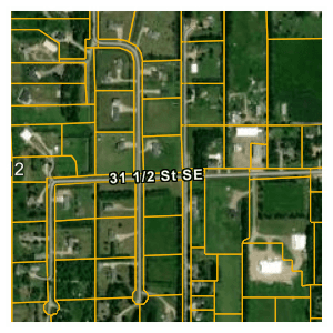
A proposed fence line, a township road or a rural parcel boundary can be checked on Stutsman County’s GIS page before a trip to the courthouse. If you are buying land, planning a fence, checking tax information, or trying to figure out which road serves a rural parcel, the county’s GIS page and property tax portal are built for that kind of first look.
Start with the map before you go to the courthouse
The quickest way to narrow a property question is to begin with Stutsman County’s GIS page. The county offers geospatial datasets and mapping services to residents, and the applications are mobile-friendly, though a desktop gives the best experience. Stutsman County spans 2,222 square miles, and the cited parcel summary listed 21,609 people, so the distances between farms, acreages and small towns can make an online check more useful than a drive.
For a homeowner, farmer or small contractor, the practical uses are immediate. You can check whether a proposed fence appears to sit on the right side of a parcel line, compare neighboring tracts before a purchase, or see how a township road and county road line up with the land you are considering.
Use the tax portal for ownership and parcel lookup
When the question turns from location to tax information, the North Dakota Property Tax Information Portal is the next stop. Its map lets you click the county you want and move into parcel tax information, which makes it a practical screen before you call for a records check. Stutsman County’s own portal also points users toward the North Dakota Parcel Viewer when they are looking for GIS data, so the two systems work together rather than as separate chores.
GIS is for spatial understanding: parcel shape, map layers, roads, and nearby land. The property tax portal is for tax-related parcel lookup. If you are reviewing a home purchase, that distinction helps you separate the questions of where the land sits from how it is taxed.
A simple before-you-call process
1. Open the Stutsman County GIS page first if your question is about land shape, neighboring lots, road access or general location.
The county has built the site to be mobile-friendly, but a desktop is still the better choice for detailed work.
2. Switch to the North Dakota Property Tax Information Portal if you need parcel tax information.
The portal routes you through an interactive county map, which is a fast way to get to the right parcel without guessing the office or document number.
3. If you want broader GIS details, move into the North Dakota Parcel Viewer.
That tool can be used to view details about tax parcels and submit requests for data review.
4. If the map answer and the recorded information do not line up, stop there and verify the record with county staff or in person.
Online tools are excellent for screening and comparison, but they are not a substitute for the official file when a legal boundary, ownership question or tax discrepancy needs confirmation.
Why roads, drainage and county services make the map matter
Map accuracy is not an abstract concern in Stutsman County. The county’s Road Department is responsible for building, maintaining, graveling, signs, culverts, bridges and snow removal on county roads. A road edge, culvert location or snow route can affect access and use long before a contractor shows up or a farmer plans a field approach.
The same goes for rights-of-way, drainage and adjoining land, which appear where parcel layers meet road lines.
Use the tools carefully and keep searches narrow
Online parcel systems work best when you keep the first pass focused. iTax portal guidance directs users to search only one criterion at a time, which is a useful rule for any land lookup system. If you know a parcel number, owner name or property address, start with one field and let the result load before adding anything else.
That approach is especially helpful when you are comparing properties across rural areas. A clean search by one criterion makes it easier to tell whether you have the right tract near Jamestown or a different parcel outside town. It also reduces the chance of mistaking one similar-looking record for another when several family parcels or adjoining acres sit close together.
A wider state system sits behind the local tools
Stutsman County’s map pages are part of a larger North Dakota system. The GIS Hub is operated by the North Dakota State Geospatial Committee and North Dakota Information Technology through a general-fund appropriation.
The North Dakota Parcel Viewer also fits into that statewide setup. It is designed to show details about tax parcels and accept requests for data review, which gives landowners and buyers another route for checking the basics before they ask for a staff review.
The old paper maps are still part of the story
OldMapsOnline lists a 1903 soil map for the Jamestown sheet and a 1911 atlas and plat book of Stutsman County. Today’s GIS tools do the same job in a faster format, with layers that can be opened from a phone or desktop instead of a bound volume on a shelf.
This article was produced by Prism’s automated news system from verified source data, official records, and press releases, then run through automated quality and moderation checks before publishing. The system is built and supervised by the people who set the standards it runs under. Read our full AI policy.
Did this article answer your question?