Texas County playa lakes shape water, wildlife and farmland
Texas County’s shallow playa lakes help catch runoff, support birds and waterfowl, and shape the groundwater and farm economy that daily life depends on.
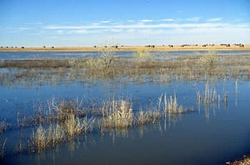
Texas County’s playa lakes are easy to overlook until rain turns a flat field into a shallow basin of standing water. In a county that spans 2,048.82 square miles and had 21,384 people in the 2020 Census, these temporary wetlands sit inside a working landscape of farmland and rangeland, where every patch of stored water and wildlife cover has a practical consequence.
What a playa lake looks like here
One of the clearest local examples sits one-half mile north and two miles east of Tyrone, where the Oklahoma Water Resources Board identifies a High Plains Playa reference wetland. It is a depressional basin in the Western High Plains ecoregion and Southern High Plains MLRA that fills from rain or snowfall runoff. That is the basic playa pattern across Texas County: a shallow low spot that holds water when weather allows, then dries back down.
The shape and scale make playas distinct from permanent lakes. Playa wetlands are generally oval, range from one to several hundred acres, and usually hold water no deeper than 60 inches, although some can exceed 8 feet at maximum capacity, according to the Oklahoma Water Resources Board. After a storm, that means a playa can look like a temporary inland pond; during dry stretches, it can fade into the surrounding field and be missed altogether.
Why they are part of the county’s map, not a side note
Texas County is generally flat, with some rolling hills, and numerous playa lakes there intermittently hold water. That mix of broad open ground and shallow basins explains why playas are woven into the county’s geography rather than clustered in one corner.
Texas County is Oklahoma’s second-largest county, and the Census Bureau’s land-area figure of 2,041.3 square miles shows how much ground those basins can occupy across private property, working fields and range.
Why farm country pays attention to them
Playas matter to agriculture because they sit at the point where rainfall becomes either stored water or fast-moving runoff. The basins can temporarily hold precipitation from storms or snowfall, which gives water time to linger on the land instead of disappearing immediately across bare ground or into drainage ways. In a county dominated by farmlands and rangeland, that temporary storage affects how fields drain, how soil stays saturated after rain, and how quickly the landscape dries out again.
The Ogallala aquifer is the primary source of water for many High Plains communities and underlies nearly 122 million acres, according to Oklahoma State University Extension. The Ogallala-Panhandle aquifer beneath Cimarron, Texas and Beaver counties has the highest reported groundwater use of any aquifer in Oklahoma, according to the Oklahoma Water Resources Board. Texas County sits in the same broader Panhandle system, where surface basins and groundwater pressure are part of the same water picture.
For farmers and landowners, the practical stakes are straightforward. When playas are intact, they help slow water across the land and hold it in a shallow basin that can later evaporate or seep downward. When they are altered, filled, or plowed through, the landscape loses one of its few natural places to catch runoff before it moves on.
Wildlife uses them as a regional rest stop
Playas are the predominant wetlands and major wildlife habitat in the southern High Plains. The U.S. Geological Survey has documented more than 115 bird species in playas, including 20 species of waterfowl, along with 10 mammal species.
USGS places between 25,000 and 30,000 playa lakes in the Southern High Plains, with about 20,000 in west Texas and additional playas in New Mexico, Oklahoma, Kansas and Colorado. Texas County’s playas are one piece of that larger network, and for migrating birds they function as scattered landing sites across the plains. For hunters and bird users, that means the county’s shallow basins can be the difference between a productive stopover and a dry field.
What changes when playas degrade or disappear
If a playa degrades, the first thing many residents notice is not a scientific loss but a visible one. A basin that used to catch runoff after a storm may start shedding water faster, hold less of it, or stop looking like a wetland at all. The next changes follow quickly: fewer places for waterfowl to rest, less habitat for other wildlife, and less natural storage in a county where rainfall is uncertain.
A healthy playa is part of the recharge conversation because it creates a place where water can remain on the surface long enough to move into the soil instead of racing away.
This article was produced by Prism’s automated news system from verified source data, official records, and press releases, then run through automated quality and moderation checks before publishing. The system is built and supervised by the people who set the standards it runs under. Read our full AI policy.
Did this article answer your question?