Colorado State Forecasters Predict Below-Average Atlantic Hurricane Season This Year
Colorado State forecasters predict 13 named storms in 2026, below the 14.4 average, driven by an emerging El Niño that could produce record wind shear.

Colorado State University's tropical meteorology team released its first outlook for the 2026 Atlantic hurricane season on April 9, predicting a "somewhat below-normal" year driven by a developing El Niño that researchers say could generate near-record levels of wind shear across the Atlantic basin.
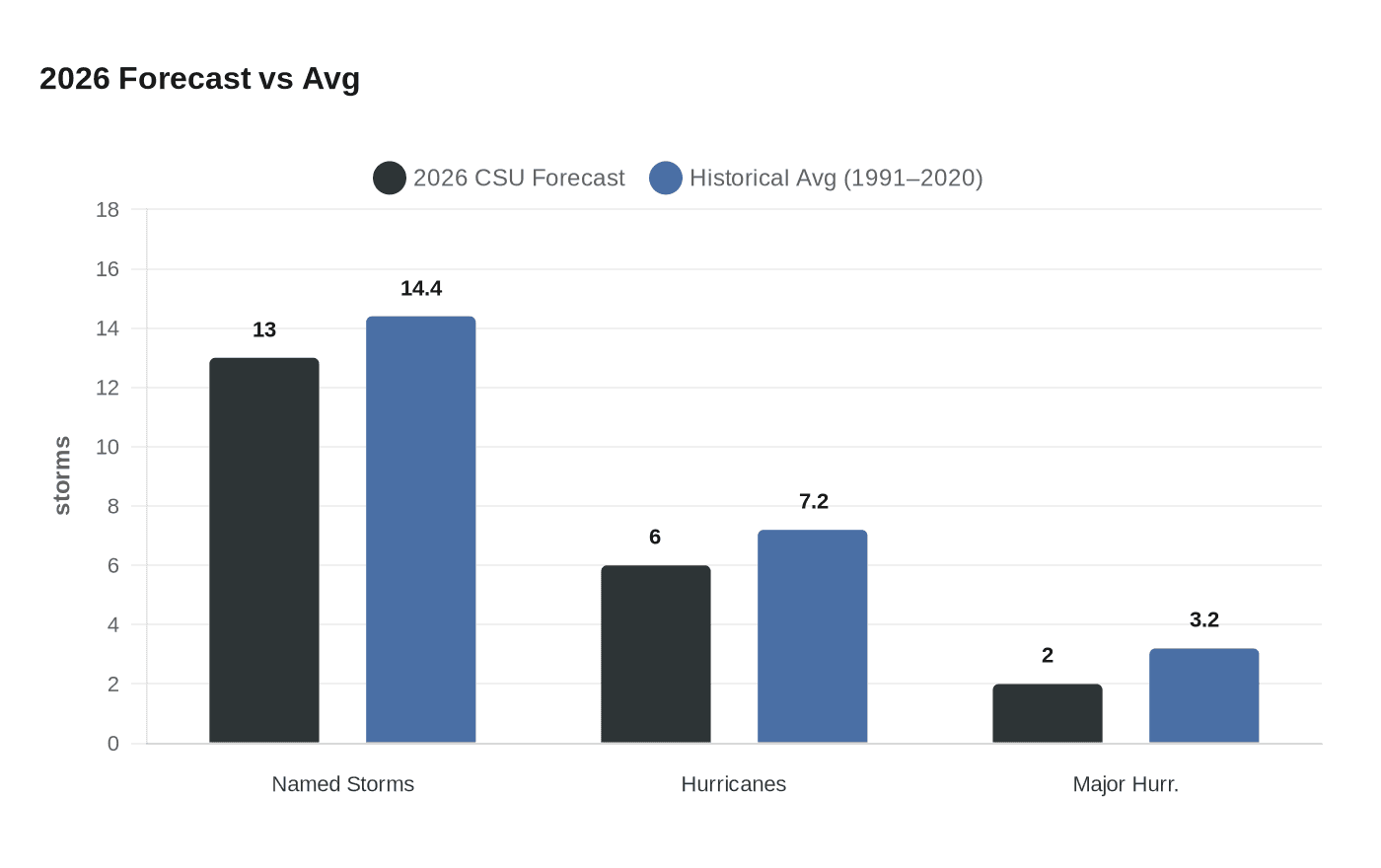
Lead researcher Dr. Phil Klotzbach and his team are calling for 13 named storms, 6 hurricanes, and 2 major hurricanes for the season that officially runs June 1 through November 30. CSU expects 13 named storms compared to the long-term average of 14.4, and about 6 hurricanes with sustained winds of at least 74 miles per hour, below the average of 7.2. Only 2 major hurricanes, Category 3 or higher storms with winds of at least 111 miles per hour, are forecast this year, also lower than the historical average of 3.2.
"At this point, we are anticipating a moderate/strong El Niño for the peak of the Atlantic hurricane season," Klotzbach said. "Typically, El Niño reduces Atlantic hurricane activity via increases in vertical wind shear." CSU anticipates wind shear across the tropical Atlantic will be the second highest since 1981, trailing only the 2015 season. High vertical wind shear acts to tilt or rip apart developing tropical systems, preventing them from organizing into powerful hurricanes.
The team predicts that 2026 hurricane activity will be about 75% of the average season from 1991 to 2020. By comparison, 2025's hurricane activity was about 105% of the average season. The most destructive storm of that 2025 season, Hurricane Melissa, made landfall as a Category 5 hurricane in Jamaica, resulting in nearly $9 billion in damage and causing 95 fatalities.
That brutal context shapes how seriously forecasters want the public to treat even a quieter outlook. Forecasters emphasize that it only takes one storm to make a season dangerous. Klotzbach noted that April forecasts carry meaningful uncertainty, warning, "There are curveballs that could come our way."
CSU's forecast includes the following probabilities of a major hurricane making landfall in 2026: 32% for the entire U.S. coastline, down from the 1880-2020 average of 43%; 15% for the U.S. East Coast including the Florida peninsula, down from 21%; 20% for the Gulf Coast from the Florida panhandle westward to Brownsville, Texas, down from 27%; and 35% for the Caribbean, down from 47%.
While those reduced probabilities may offer some comfort to insurers and coastal planners, the uncertainty baked into this forecast is substantial. Klotzbach noted that the 2026 season is exhibiting characteristics similar to 2006, 2009, 2015, and 2023, and that "the large spread in observed activity in our analog years highlights the high levels of uncertainty that typically are associated with our early April outlook."
Sea surface temperatures in the Atlantic remain near or slightly above average; the Caribbean is slightly warmer than normal, while the eastern and central tropical Atlantic are slightly cooler. This pattern of sea surface temperatures provides mixed signals regarding the potential for an above- or below-normal season. The latest models predict one of the strongest El Niños on record to develop near the typical peak of hurricane season.
CSU, which pioneered hurricane season forecasts in 1984, will update its outlook once the season begins. NOAA's official seasonal forecast is expected later in the spring. For Gulf and Atlantic coastal communities still rebuilding from prior seasons, the message from CSU's team is consistent regardless of the numbers: preparedness cannot wait for certainty.
This article was produced by Prism’s automated news system from verified source data, official records, and press releases, then run through automated quality and moderation checks before publishing. The system is built and supervised by the people who set the standards it runs under. Read our full AI policy.
Did this article answer your question?