Inside Washington’s Hoh Rain Forest, a primeval temperate wilderness
A moss-draped giant on Olympic’s wet flank, the Hoh is both ancient wilderness and a national climate test, where warming and crowds shape what survives.
Deep on Olympic National Park’s wet western flank, the Hoh Rain Forest feels less like a scenic stop than a living benchmark for what temperate wilderness once looked like across the Pacific coast. It is one of the finest remaining examples of temperate rainforest in the United States, and its value is national as much as aesthetic: a dense old-growth system in a nearly million-acre park created to preserve “the finest example of primeval forest” and protect native Roosevelt elk.
Why the Hoh matters far beyond Washington
The Hoh sits on the west side of Olympic National Park, about a two-hour drive from Port Angeles and under an hour from Forks, reached by the Upper Hoh Road off Highway 101. That remoteness is part of its power, but so is its setting inside the Pacific Northwest rainforest belt that once stretched from southeastern Alaska to the central coast of California. In the Hoh Valley, the landscape from the park boundary to Mount Olympus has remained much as it has for roughly 5,000 years, which is exactly why this place matters in the climate era: it is a rare baseline for what intact, rain-fed coastal forest can still be.
Olympic National Park itself is the conservation frame around that forest. Established in 1938, the park now encompasses nearly a million acres and protects glacier-capped mountains, old-growth temperate rain forests, and more than 70 miles of wild coastline. The Hoh is not an isolated grove but part of a larger temperate rainforest system that includes the Quinault, Queets, Hoh, and Bogachiel valleys, which the park describes as some of the most spectacular examples of primeval temperate rainforest in the lower 48 states.
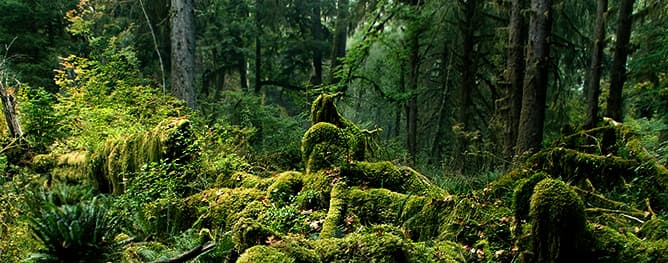
An ecosystem built on scale, moisture, and decay
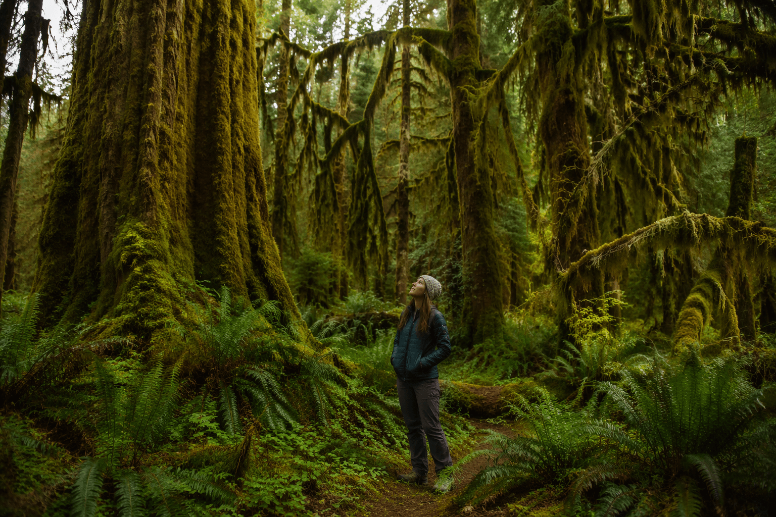
What makes the Hoh feel primeval is not just age, but structure. Many of the trees in Olympic’s temperate rainforest are hundreds of years old and can reach 250 feet in height and 30 to 60 feet in circumference. Sitka spruce, western hemlock, Douglas fir, and western redcedar dominate much of the forest, while the forest floor stays rich with mosses and ferns. Seedlings often germinate on fallen logs, creating the nurse-log and colonnade forms that define old-growth rainforest and show how little is wasted here.
That biological complexity is what makes the Hoh more than a postcard forest. The park’s rainforest system is part of one of the largest remaining blocks of old-growth and temperate rain forest in the lower 48 states, and its layered canopy stores moisture, shelters wildlife, and slows the ecological clock. When Tim McNulty wrote, “When I stop to follow a great bole of spruce from forest floor to the upper canopy, my perception changes and routine senses of scale and proportion slip away,” he captured not just a feeling, but the actual scale at which this ecosystem operates.
Wildlife, tribes, and the meaning of stewardship
The Hoh Valley is also Roosevelt elk country. Olympic National Park estimates there are 3,000 to 4,000 Roosevelt elk in the park, with about 400 to 500 living in the Hoh Valley alone. That population is one reason the park was established, and it remains one of the clearest signs that the valley is not simply preserved scenery, but functioning habitat for a large native ungulate species.
Long before the park boundary existed, and long before the Hoh became a destination for hikers and photographers, eight contemporary tribes of the Olympic Peninsula, the Hoh, Quileute, Makah, Quinault, Skokomish, Port Gamble S’Klallam, Jamestown S’Klallam, and Lower Elwha Klallam, had deep and continuing ties to these lands and waters. The National Park Service says these tribes have lived here since time immemorial and continue to maintain strong relationships to the places now within Olympic National Park. Any serious conversation about conservation in the Hoh has to include that living history, not just trees and trails.
What warming changes in a rain forest that still looks ancient
The Hoh may be lush, but it is not insulated from warming. Olympic National Park treats climate change as a core management issue, with scientists monitoring conditions across the park and describing climate as a dominant driver of ecological processes. In the Olympic Mountains, even small temperature shifts matter because they can change whether precipitation falls as snow or rain, a shift that affects glaciers, streamflow, and the timing of water available to sensitive ecosystems.
That matters for the Hoh’s broader watershed because the rainforest does not exist in isolation from the alpine headwaters that feed the park’s rivers. The park’s climate monitoring and glacier research are an early warning system for those changes, and the National Park Service has said climate adaptation and science-based stewardship are now central to managing public lands. The risk is not that the Hoh will suddenly lose its rain forest identity, but that warming can alter the hydrology and disturbance patterns that keep this ecosystem stable over time.
Tourism pressure and the access bottleneck
The Hoh’s popularity is itself a conservation issue. The park calls it one of its most popular destinations, and summer visitation can strain access: parking at the Hoh Rain Forest Visitor Center is limited, lots can fill completely on weekends and holidays, and wait times can run long when the entrance queue backs up. When a place is this sought after, the pressure lands first on roads, parking, and trailheads, then on soils, vegetation, and the visitor experience that makes the forest feel wild in the first place.
Access is especially fragile because the Upper Hoh Road is the only route to the visitor center, campground, picnic area, and trailheads, and it is maintained by Jefferson County. Recent closures tied to washouts and flooding show how quickly a single road can determine whether the Hoh is open or cut off, turning local infrastructure decisions into national-park access decisions. That is the kind of federal-land-management reality the Hoh now faces: stewardship is not only about protecting trees, but about deciding how people reach them and how much strain the place can bear.
How to experience the Hoh without diminishing it
A good visit starts at the visitor center and stays on the marked system around it. The Hoh area includes a campground, picnic area, self-guided nature trails, and summer ranger-led programs, which make it easy to see the forest without pushing deeper than the site can absorb. The best approach is slow, not ambitious: let the scale of the canopy, the moss, and the fallen logs do the work.
Keep one warning front of mind: swimming and boating on the Hoh River are considered extremely dangerous and are not recommended. The river may look calm from shore, but the park’s own guidance treats it as a serious hazard, and that caution is part of respecting the place rather than simply consuming it. In a forest that has outlasted every modern management trend, restraint is a form of stewardship.
The Hoh Rain Forest endures because it is both resilient and fragile, a dense old-growth refuge in a park designed to protect what the rest of the continent has largely lost. Its future will depend on how well managers balance climate adaptation, access, and tribal stewardship with the public’s desire to see one of America’s last great temperate rainforests still standing.
This article was produced by Prism’s automated news system from verified source data, official records, and press releases, then run through automated quality and moderation checks before publishing. The system is built and supervised by the people who set the standards it runs under. Read our full AI policy.
Did this article answer your question?