Wildfires, Strong Winds Push Smoke and Evacuations Across Oklahoma, Texas Panhandle
Tyrone was evacuated as the Side Road fire in Texas County burned 3,300 acres, was 25% contained and sent heavy smoke into Liberal and surrounding communities.

Tyrone was reported evacuated as fast-moving wildfires and strong winds drove smoke across the Oklahoma and Texas Panhandle on Feb. 17–18, 2026. The Side Road wildfire in Texas County was discovered Feb. 17 at 2:20 p.m., listed at 3,300 acres and 25% contained with an estimated cost of $7,221; fire warnings were posted for Beaver and Texas counties while smoke reached Liberal and nearby areas.
Satellite analysis and NOAA imagery showed large plumes moving east from the central Plains. "SMOKE: Colorado/Kansas/Oklahoma/Texas - Wildfires generated large plumes of moderate-to-thick density smoke in the central United States. The heaviest smoke was observed moving eastward from fires in northern Texas, western Oklahoma, and eastern Colorado," the satellite narrative reported. Blowing dust west of the fires mixed with the smoke plumes as they expanded across most of Kansas and continued toward Missouri, where visibility was obscured by a weather system.
Local fire weather intensified the threat. "The first fire warnings were issued late morning and early afternoon in the Oklahoma Panhandle for fires spreading rapidly to the northeast in strong winds," CNN reported. Forecasters warned that "the fire weather concerns will peak this afternoon as winds reach their peak and humidity levels bottom out to their lowest level between 10 to 15%." Officials added that "conditions will remain dangerous into the early evening hours before easing up overnight."

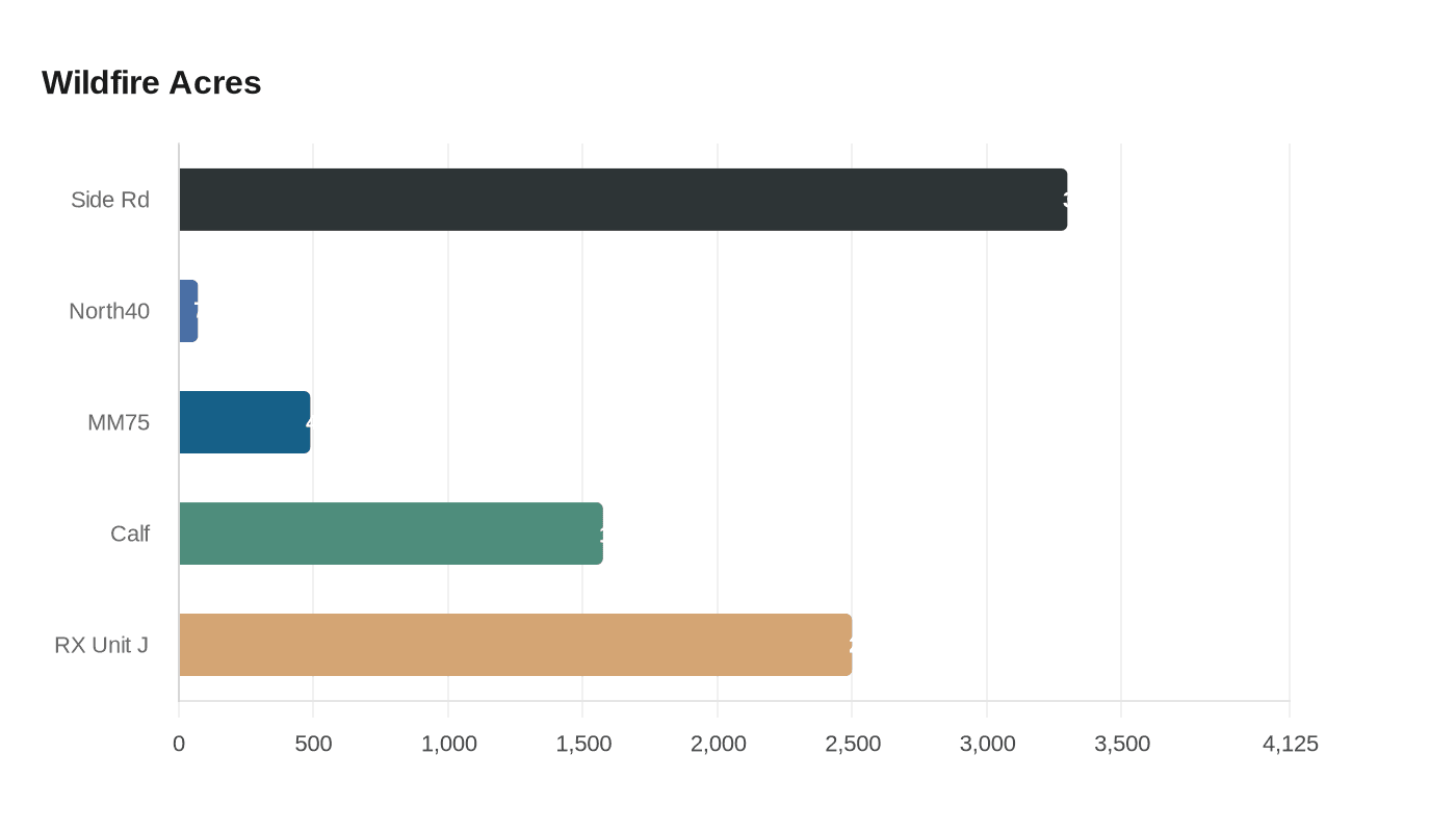
Multiple other Oklahoma incidents were active or recently controlled in February, according to regional incident lists. The North 40 wildfire in Pottawatomie County was discovered Feb. 9 at 3:09 p.m., listed at 71 acres and 100% contained with $13,400 in costs. MM 75 in Custer County was logged Feb. 9 at 3:18 p.m., at 488 acres and 100% contained with $67,300 in costs. The Calf Fire in Pittsburg County dated Jan. 15 was listed at 1,575 acres and 100% contained with $25,000 in costs, and prescribed burns such as RX OK-SLR UNIT J in Alfalfa County were recorded at 2,500 acres with containment listed as unknown.
Air quality and public health tracking were uneven during the event. AirNow urged residents to use its Fire & Smoke Map and health guidance pages such as Be Smoke Ready and When Smoke is in the Air, but some monitoring pages reported limited data availability for nearby locations at the time. The mix of moderate-to-thick smoke and blowing dust prompted reduced visibility across parts of Kansas and into Missouri, raising short-term respiratory risks for people in Liberal, Tyrone, Beaver County and Texas County.
The Side Road incident remained the primary Panhandle fire tied to the Feb. 17–18 outbreak, recorded at 25% containment and 3,300 acres after its 2:20 p.m. discovery on Feb. 17. CNN invoked the region’s wildfire history as context, noting that "2024’s Smokehouse Creek Fire in the Texas Panhandle, the state’s largest wildfire, burned through more than 500 structures," underlining the stakes for communities facing similar conditions.
Know something we missed? Have a correction or additional information?
Submit a Tip