Meshtastic Site Planner helps predict mesh coverage before deployment
Meshtastic's Site Planner lets you test terrain, antenna height, and receiver settings before buying hardware or bolting up a node.
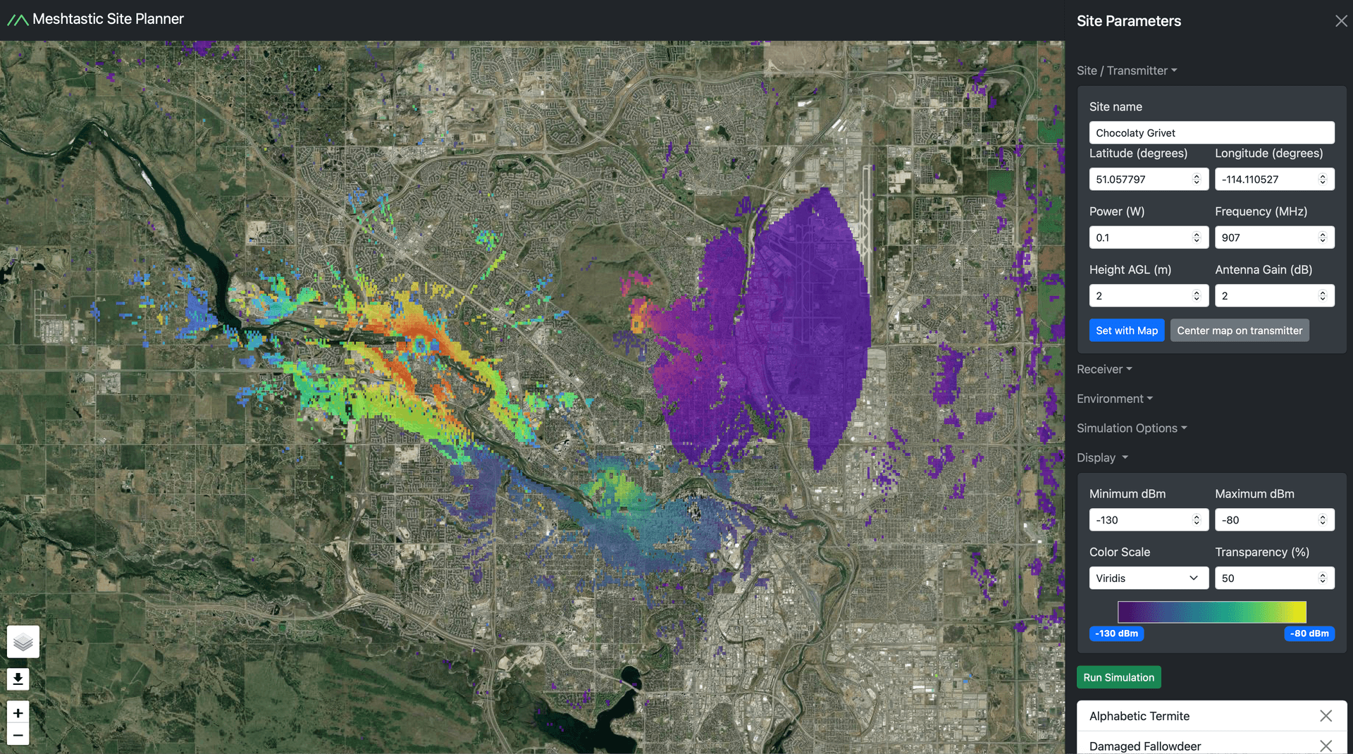
Meshtastic’s Site Planner predicts node range and coverage before a single node goes on the roof. The open-source web utility shows where terrain, placement, and radio settings will help or hurt a deployment before you spend money on hardware or labor.
A planning tool for real deployments
Site Planner is a response to proprietary, expensive, and difficult-to-use software that often stands between a good idea and a working mesh. On the Meshtastic blog, data scientist Matthew Patrick presents it as a practical tool rather than a demo. The biggest mistakes in Meshtastic are usually physical ones: a node on the wrong ridge, a bad antenna choice, or a repeater placed where the terrain eats the signal.
Site Planner is an open-source web utility for predicting node range and coverage. Its source code lives in the meshtastic/meshtastic-site-planner repository, and the planner is built around a containerized API running the SPLAT! RF analysis software. That gives the tool a clear modeling backbone instead of a black-box estimate.
What you can model before you deploy
The planner is designed around the choices Meshtastic operators actually make in the field. Settings sit under `Site Parameters > Site / Transmitter`, `Site Parameters > Receiver`, and `Simulation Options > Receiver`, with a `-130 dBm` receiver threshold and the `LongFast` preset.
A useful way to think about it is as a pre-install checklist you can run on screen. If you are planning a hilltop repeater that needs to serve a valley trail, a rooftop node in town, and a vehicle moving through the edge of the coverage area, the planner lets you place each radio site and compare the shape of the mesh from each location. Because it supports multiple radio sites in one simulation, you can see which placement gives you the cleanest path and which one looks good on paper but collapses once the terrain is added.
A simple reusable workflow looks like this:
1. Set the transmitter site where you think the node will live, such as a hill, roof, or mast.
2. Add receiver locations for the places you actually need to reach, including a trailhead, building, or vehicle path.
3. Use the transmitter and receiver parameters, including the `LongFast` preset and the `-130 dBm` receiver threshold, to model the link.
4. Compare the predicted coverage for each site before you buy an antenna, run cable, or climb the structure.
Meshtastic range problems often come from expensive mistakes. A ridge line can block the path even when a map suggests the link should work, and a poorly chosen mount can leave you paying for a taller mast or a different antenna after the fact.
Why the open-source approach matters
Meshtastic’s broader philosophy has always leaned toward transparency, and the Site Planner fits that model cleanly. The tool uses “sophisticated and proven radio propagation models,” and the SPLAT!-based backend makes the modeling engine part of the system instead of a hidden assumption. That means you can inspect how the simulation is being built, adjust the inputs, and understand why a particular location looks strong or weak.
The practical payoff is not limited to new builds. A live network that underperforms can be compared against the planner’s prediction, which helps separate a bad install from a bad expectation. If the map says a hilltop should cover a canyon and the mesh still dies halfway down the slope, the likely next steps become clearer: move the antenna, change the node height, or shift the repeater position rather than just adding more hardware.
A better fit for field use
That kind of planning is especially useful for community networks, search-and-rescue volunteers, outdoor groups, and homestead users who need repeatable results instead of radio folklore. Meshtastic is moving farther from the “I hope this reaches” stage and closer to a system where placement, terrain, and preset choice can be checked before the install begins. The planner now sits in the project’s official documentation and codebase.
This article was produced by Prism’s automated news system from verified source data, official records, and press releases, then run through automated quality and moderation checks before publishing. The system is built and supervised by the people who set the standards it runs under. Read our full AI policy.
Did this article answer your question?