A better way to fold paper charts for small sailboats
The best backup chart is the one you can grab in seconds. On a small sailboat, a third-fold turns paper charts into a real navigation tool, not dead weight.
Steve Christensen’s simple chart-folding method keeps paper charts compact without turning them into a wrestling match every time you need one course line, one waypoint, or one harbor entrance. That matters when the plotter blanks out, the cockpit is wet, and the only thing between you and guesswork is a sheet of paper stuffed into a tight nav station.
Why the usual fold wastes time
Most sailors default to the same bad habit: fold the chart in half, then in half again, until it becomes a dense square that will fit somewhere. It works for storage, but it is terrible for actual use because the moment you want a specific area, you usually have to unfold the whole chart, hunt for the section, and then refold it in the dark or in a heeled boat.
That is the real issue on small sailboats. Rolling charts can help if you have room, but most boats do not have the luxury of a wide chart table or a clean tube storage setup. In a cramped nav station, the chart is part of the backup-navigation workflow, which means it has to move quickly from stowed to useful and back again without taking over the whole cabin.
A better fold for cramped spaces
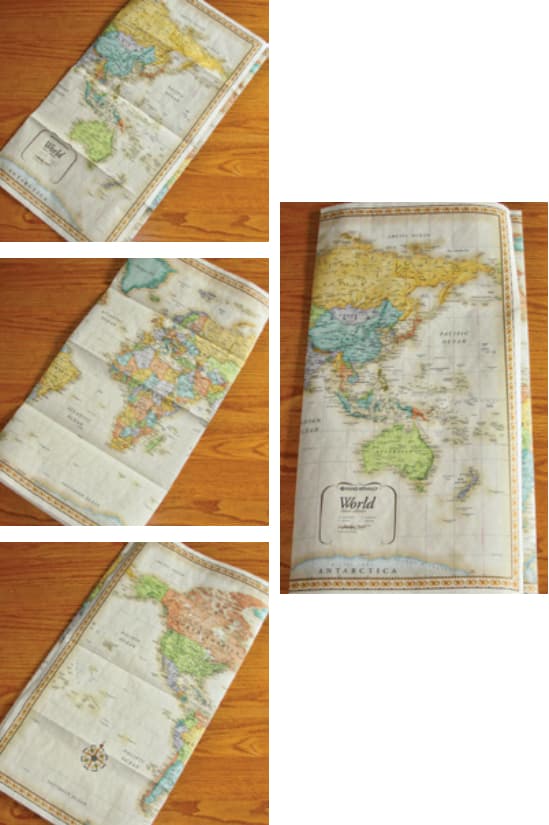
Christensen’s method, which he picked up from an orienteering book, starts by treating the chart as a working tool instead of a flat poster. Instead of collapsing the long axis into a compact square, divide that long dimension into thirds, with the middle section slightly larger than the two outer sections. That first set of folds preserves vertical panels that you can expose one at a time.
The practical payoff is immediate. You can open only as much of the chart as you need, get the area in front of you, and leave the rest of the sheet under control instead of flapping across the cabin. When you are plotting a harbor approach, checking a channel marker, or confirming a distance off a shoal, that matters more than perfect symmetry. The chart stays readable, the fold pattern survives repeated use, and you are far more likely to put it back in order after you are done.

- Fold the chart along the long axis into thirds rather than repeated halves.
- Make the center panel slightly wider so the outer folds sit neatly.
- Keep the folds aligned so the chart opens in stages instead of all at once.
- Store it where you can reach it one-handed, because that is how it will get used in rough water.
If you want to make it work cleanly, keep the process simple:
Why this is seamanship, not stationery
A chart that is easy to unfold, read, and restore to its original fold is more likely to be used when the boat is busy, the crew is distracted, or the conditions are ugly.
On small sailboats, every square inch of storage counts and every task has to be done with one eye on the cockpit. If the chart takes too long to deploy, the crew will reach for the easiest electronic screen and stay there. If the paper is organized and quick, it gets used.
The chart world has changed around this habit
NOAA has been producing the nation’s nautical charts for nearly two centuries, but its primary chart product is now the electronic navigational chart. NOAA sunset its traditional paper and raster chart production, canceled the last of its 1,007 paper charts in December 2024, and saw sales of NOAA paper nautical charts fall by more than 50% between 2010 and 2020.

NOAA’s NOAA Custom Chart application can create customized paper charts from ENC data, which fits perfectly with the small-boat reality Christensen is addressing: if you need paper as a backup, you want the piece you actually carry to be targeted to your sailing ground, not a giant stack of oversized sheets you cannot store.
NOAA also published Technical Memorandum NOS CS 60 in November 2024, laying out best practices for creating and maintaining ENC-derived paper nautical charts. And if you need to read the language on those charts, U.S. Chart No. 1, produced by NOAA and the National Geospatial-Intelligence Agency, is still the official symbol guide for the symbols, abbreviations, and terms used on nautical charts.
What the rules say, and why sailors still carry paper
The U.S. Coast Guard’s August 18, 2025 NVIC 01-16 CH-3 allows vessels subject to chart and publication carriage requirements to comply with electronic charts, electronic publications, or ENC-derived paper charts.
The Coast Guard does not provide charts to the public, so chart supplies still have to come from elsewhere. On top of that, World Sailing’s Offshore Special Regulations 2026-2027 took effect on January 1, 2026.
This article was produced by Prism’s automated news system from verified source data, official records, and press releases, then run through automated quality and moderation checks before publishing. The system is built and supervised by the people who set the standards it runs under. Read our full AI policy.
Did this article answer your question?