Perryville’s river town history shaped by dam, flood, and reinvention
Perryville was reshaped by the dam, the bridge, and the river that split the county seat. Its past still drives how Decatur County travels and recreates.

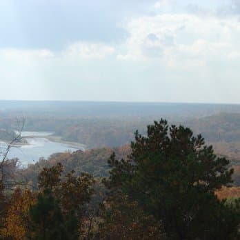
Perryville still shows how a river can remap a county without erasing a town. The oldest community in Decatur County began as a landing, became a county seat, and later absorbed the losses and opportunities created by the Gilbertsville Dam era. Its story explains why Decatur County lines, crossings, and river access look the way they do now.
From county seat to river landing
The Decatur County Historical Society describes Perryville as the oldest town in the county, incorporated in 1825 and already serving as the county seat of Perry County by 1821. It sat on the Tennessee River, five miles east of Parsons, where water traffic made it a natural stopping point for trade and travel. That location gave the town its first economic purpose: not as a backwater, but as a working river landing tied to movement up and down the corridor.
Early merchants built that role into a wider trading network. Samuel McClure was among the early names attached to Perryville commerce, and later James M. Pettigrew and Curry Pettigrew extended the town’s reach through branch stores in Decaturville, Oak Grove, Spring Creek in Madison County, and Beardstown in Perry County. The town’s business life spread well beyond its core streets, which is part of why Perryville mattered to the county long before modern highways and bridges were in place.
Railroad-era growth added another layer. The historical society’s account notes wholesale houses, grocery stores, and the Dennison Hotel among the businesses that followed the railroad’s arrival. Perryville was no longer just a river stop, it had become a commercial center that served nearby communities on more than one route.
How the dam changed the town’s footprint
The biggest break in Perryville’s story came with the Gilbertsville Dam era. When the dam raised water levels, business places and some houses were flooded, and the old town folded as a full riverfront settlement. Lakes formed where the river system changed, and those new waters became a draw for sportsmen, turning a once-productive landing into a place defined as much by recreation as by commerce.
That shift was not only physical, it was administrative and social. The Perryville Post Office closed on November 26, 1971, a quiet but clear marker that the town no longer functioned as the full-service river town it once had been. The community itself remained, but the services, streetscape, and daily rhythms that had centered on the old river landing were gone.
A new use for the altered shoreline emerged in 1944, when Doc Burton built the Perryville Marina Boat Dock in what had once been a small branch but had become a much larger lake formed by the dam. Today, Perryville Marina still ties the town to the Tennessee River with boat slips, fuel, and fishing access. That continuity matters in Decatur County because it shows how the same water system that displaced structures now supports tourism and lake-based recreation.
Why county lines changed here
Perryville’s river geography did more than affect trade. It helped redraw county government. Decatur County was created from Perry County in 1845 because the county seat at Perryville was divided by the Tennessee River, which made administration difficult for residents on the west side. The historical society says 200 citizens from that side of the river, led by Samuel Brasher, petitioned for a new county.
That petition turned geography into governance. A river crossing that once helped Perryville thrive eventually made it impractical as a county seat for everyone it served, and the result was a new county with its own boundaries and institutions. Decatur County’s creation is one of the clearest examples in the region of how a natural barrier can become a political one.
That legacy still matters when county leaders think about access, response times, and where people have to travel for services. Perryville’s divided position explains why the Tennessee River has long been more than scenery in Decatur County. It has been a factor in how people reached government, markets, and one another.
The bridge that kept Perryville connected
The Alvin C. York Bridge helped answer that access problem. Construction began in 1928, and the bridge opened on July 4, 1930. The project cost $665,000 and was operated as a toll bridge to help defray construction costs.
The bridge gave Perryville and the surrounding area a safer, more dependable crossing than river traffic alone could provide. That mattered for business, travel, and daily life, especially in a county where the river had already influenced where people lived and where government sat. Even as river commerce changed, the bridge kept Perryville relevant as a crossing point rather than leaving it stranded on a remade shoreline.
The Tennessee Valley Authority and the river today
Perryville’s modern setting is inseparable from the Tennessee Valley Authority’s river system. TVA says it was tasked from the beginning with taming flooding on the Tennessee River, and it now manages the river for navigation, flood control, electricity, and economic development. The agency also says its dams prevent about $309 million in flood damage each year across its region.
That flood-control system is the larger framework behind Perryville’s transformation. The same managed waterway that altered the old town also protects downstream communities, supports navigation, and powers regional development. For Decatur County, that means the river is still a working public system, not just a historical landmark.
TVA also provides daily lake-level and stream-flow data, along with recreation information for its reservoirs. That information affects boating, fishing, and lake access around Perryville today, especially for people using the marina and nearby waters. In practice, Perryville sits at the intersection of memory and management: a town shaped by loss, preserved by adaptation, and still defined by the river that changed it.
This article was produced by Prism’s automated news system from verified source data, official records, and press releases, then run through automated quality and moderation checks before publishing. The system is built and supervised by the people who set the standards it runs under. Read our full AI policy.
Did this article answer your question?