VDOT study weighs traffic, transit needs in West Creek area
West Creek’s traffic pinch points could shape Goochland’s next wave of growth, from Route 288 access to transit and intersection upgrades.
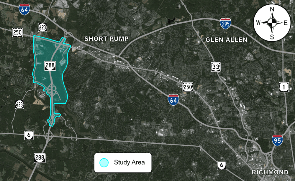
West Creek is where Goochland’s growth question becomes a road question. The Virginia Department of Transportation study covers the corridor bounded by I-64, West Creek Parkway, Route 623, known locally as Hockett Road, and the Goochland-Henrico line, a section of the county where commuters, freight traffic, new employers, and neighborhood access all compete for the same pavement.
Why this corridor matters
The study area sits about 15 miles northwest of downtown Richmond, southwest of Short Pump, and near the I-64 and Route 288 interchange. That location makes every turn lane, signal, and connector road more than a local convenience. It affects how people reach West Creek Business Park, how trucks move in and out of the east end, and how traffic spills toward Henrico County and the western edge of the Richmond metro area.
For Goochland County, the real issue is not simply whether traffic moves today. It is whether the road network can keep pace with the kind of development already clustered around Route 288 and West Creek Parkway. The study is designed to answer that by looking at the transportation network as a whole and defining what the future roadway network should look like.
What VDOT is trying to solve
VDOT says the study will evaluate solutions that improve capacity, operations, and safety while also considering pedestrian, bicycle, and public-transit needs. That matters because West Creek is no longer a single-use office park with predictable rush-hour patterns. It is a growing employment and development district where people arrive by car, by truck, and increasingly through mixed land-use corridors that need more than one mode of travel.
The study is a partnership effort involving Goochland County, the Richmond Regional Transportation Planning Organization, and Greater Richmond Transit. That mix signals that the county is not treating the area as a stand-alone road problem. It is being viewed as part of a broader regional system, one that has to handle commuting patterns, access to jobs, and future service options beyond private vehicles.
Kathryn Benedict is listed as the VDOT project manager. The study was estimated to start in fall 2023 and was budgeted at $448,994.24, which puts it firmly in the category of a planning and forecasting effort rather than an immediate construction job.
The timeline points to later roadwork, not quick fixes
The milestone sequence shows how the study has moved from diagnosis to recommendation. An existing-conditions analysis was completed in April 2024. A public survey focused on current issues followed in May 2024. Future traffic forecasts were completed in summer 2024, and alternatives analysis came in spring 2025. Final recommendations are expected in summer 2026.
That timeline matters because it tells residents and developers what this document can do. It is not a shovel-ready project list. It is the planning framework that can shape later capital work, including connector roads, intersection changes, route realignments, and transit adjustments. Any major construction that follows would still need separate funding, design, and approval steps.
For people watching county growth, that distinction is critical. The study can influence where access points are allowed, how sites are laid out, and which improvements are likely to rise to the top when the county and state decide what gets built first.
West Creek Business Park is driving the pressure
West Creek Business Park is the economic engine behind much of this attention. Goochland County Economic Development describes it as a 3,500-acre business park at the intersection of State Route 288 and West Creek Parkway, zoned for mixed-use office, retail, and light industrial uses. Another business-park source says the area stretches from Broad Street to Patterson Avenue and already includes more than 2.1 million square feet of office space.
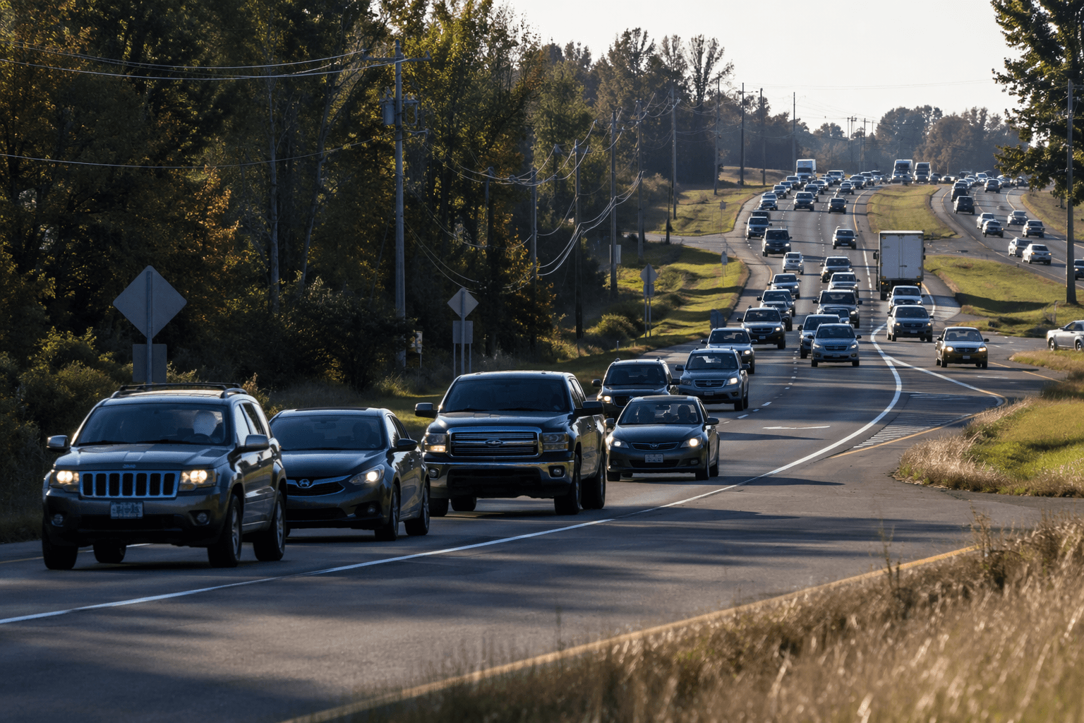
That scale explains why the transportation study has such high stakes. A corridor built around office space, industrial uses, retail, and future mixed-use development needs reliable access for workers, customers, service vehicles, and emergency response. Once traffic starts backing up at a few key intersections, the effects spread quickly across the entire east end.
The public response also suggests the issue is not abstract. The survey tied to the study drew 1,337 comments from 997 respondents, a strong sign that residents and road users see the network as more than a background planning issue. They are already weighing how congestion, safety, and access will affect daily life.
New projects raise the stakes even higher
The most direct test of the road network is the wave of development already landing in West Creek. In September 2025, Governor Glenn Youngkin announced that Eli Lilly would locate a $5 billion manufacturing facility in West Creek Business Park. The project is expected to bring 1,800 construction jobs and 650 permanent jobs to a 227-acre site at 12575 West Creek Parkway.
Then came another signal that the district is still expanding. West Creek Commerce Center, a 221,231-square-foot speculative warehouse, broke ground in April 2026 on a 23.18-acre site in the business park. A manufacturing campus, warehouse space, and existing office employment together create a much heavier demand on roads than the corridor faced a decade ago.
That is why the transportation plan is not just about today’s traffic counts. It is about what happens when trucks, employees, contractors, and support services all arrive in the same part of the county at once.
A longer pattern of tying roads to growth
West Creek’s transportation planning sits inside a much longer Goochland story. County materials point to a 1975 comprehensive plan that identified a planned service area for eastern Goochland, a 1995 rezoning that helped create West Creek Business Park, and a 2002 proposed Motorola plant that pushed investment in roads and utilities. Those milestones show a familiar pattern: infrastructure comes first, or at least alongside development, when the county wants growth to happen in a managed way.
That history helps explain why the current study matters so much to development approvals. The county has repeatedly used road and utility planning to decide how far east-end growth can stretch and what kind of access that growth can support. The new study is the latest version of that same playbook.
What residents and businesses should watch next
The most useful takeaway is practical. The final recommendations expected in summer 2026 could shape where future congestion builds, where new turning lanes may appear, and which parts of West Creek become easier or harder to reach. Residents should watch for changes tied to intersection upgrades, access management, and possible route shifts around Route 288, West Creek Parkway, and Hockett Road.
Businesses should pay close attention to how the plan treats truck circulation, employee access, and transit options. If the study points toward new connectors or modified access points, that will affect site design, traffic counts, and how quickly new projects can move through review. For Goochland’s east end, this is the kind of document that helps determine whether growth stays manageable or starts colliding with gridlock.
This article was produced by Prism’s automated news system from verified source data, official records, and press releases, then run through automated quality and moderation checks before publishing. The system is built and supervised by the people who set the standards it runs under. Read our full AI policy.
Did this article answer your question?
