New Pawnee Pioneer Trails Byway Itinerary Maps 128-Mile Colorado Route
A 128-mile itinerary tracing Logan County's Pawnee Pioneer Trails byway was published March 24, connecting Sterling and Fort Morgan to the fossil-rich Pawnee Buttes.
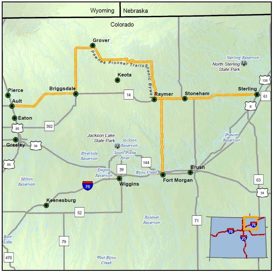
A fresh itinerary for the Pawnee Pioneer Trails Scenic and Historic Byway dropped March 24 as part of Colorado's Great American Road Trip campaign, a statewide effort to spotlight all 26 Colorado Scenic and Historic Byways during the America 250 and Colorado 150 anniversary year. The guide maps a T-shaped, 128-mile route through Logan, Morgan, and Weld counties, connecting Sterling and the heart of Logan County westward to Fort Morgan and the small agricultural anchor of Ault.
Sterling serves as the eastern gateway to the byway, and it's a logical starting point. Begin with a visit to the Overland Museum, established in 1936, which holds a wealth of historic information about the entire region from ancient times to modern day. The Overland Trail Museum focuses specifically on the history of Logan County. The jewel of downtown Sterling is the Logan County Courthouse, built in 1910 in the Classical Revival style.
From Sterling, the drive heads west on Colorado State Highway 14. In approximately 25 miles, it passes through Stoneham, which still contains a chapel and a 1907-era post office, and is world-renowned for its brilliant blue barite crystals. In another nine miles is one of the arms of the byway's T shape, where a left onto Colorado State Highway 52 leads on a straight, 25-mile shot south to Fort Morgan.
Fort Morgan anchors the southern arm of the route. It's the agricultural town where swing great Glenn Miller went to high school. The Fort Morgan Museum covers exhibits ranging from the pioneer era to Miller's cultural legacy. The city's Rainbow Bridge, one of the famous Marsh Arch Bridges, is on the National Register of Historic Places and has been designated a Colorado Civil Engineering Landmark. Now pedestrian-only, it offers unobstructed views of the South Platte River. At the corner of 3rd and Main, a bronze statue honors Clarence Mentgen, known locally as The Popcorn Man, who worked that corner for 40 years.
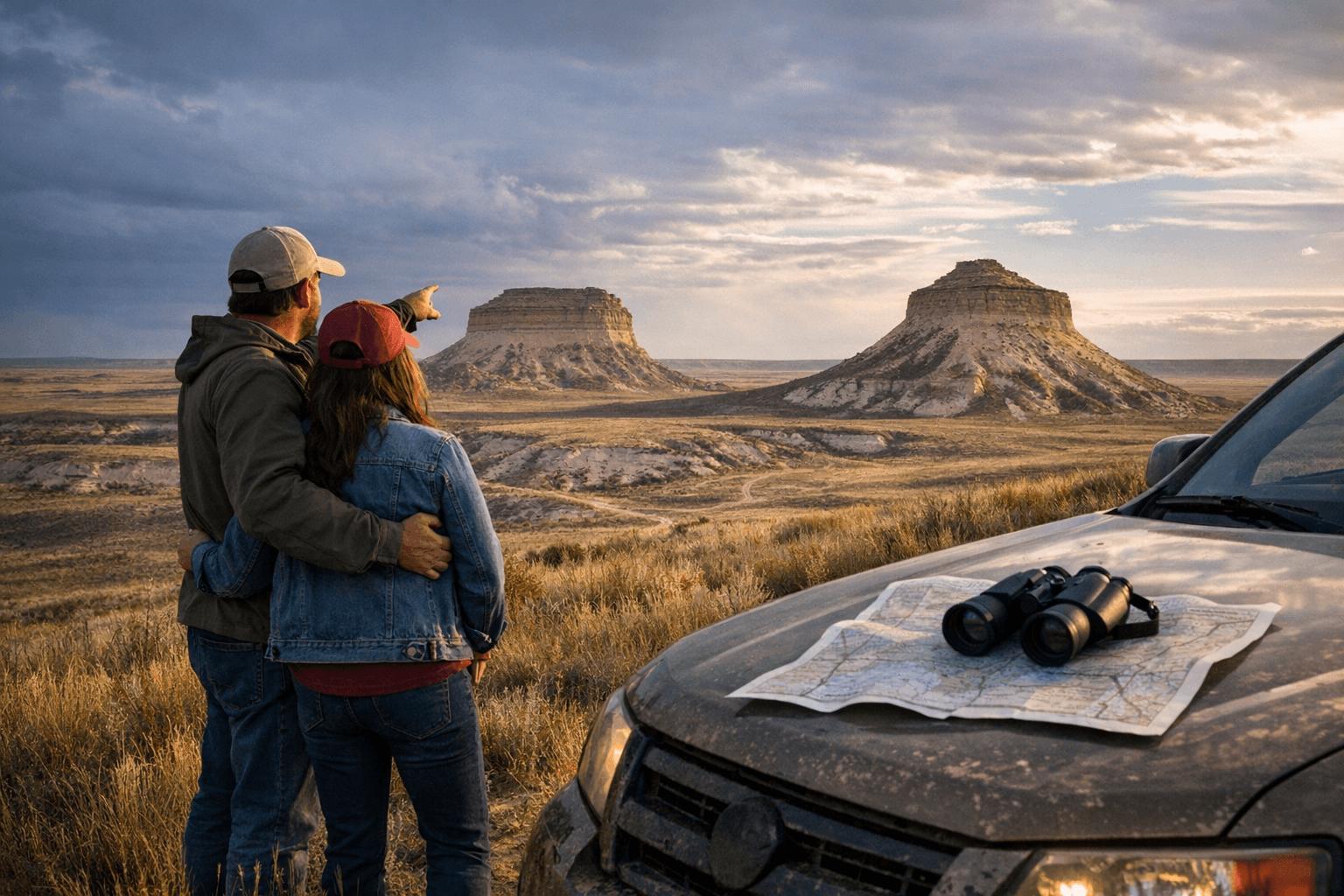
The natural centerpiece of the entire byway sits within the Pawnee National Grassland, which spans 193,060 acres managed by the National Forest Service across a 30-by-60 mile area. Meadowlarks sing from their perches, antelope graze in the distance, and the twin mesas of the Pawnee Buttes jut up from seemingly nowhere. The sandstone buttes rise roughly 300 feet above the surrounding grassland and sit at an elevation of 5,500 feet above sea level. From March 1 through June 30, the north overlook and cliffs near the Pawnee Buttes are closed to the public by the Forest Service for raptor nesting protection. Hawks, falcons, and swallows nest in those cliffs from July through February. The Pawnee Buttes Trail covers a 4-mile round trip to both East and West Pawnee Butte. The buttes are considered one of the world's best sites for vertebrate fossils, with some 100 species identified in the area.
The landscape provides refuge for coyotes, prairie dogs, rattlesnakes, pronghorn antelope, and hundreds of bird species. Birding draws visitors from across the region. Climbing on the buttes and other cliffs is discouraged due to crumbling sandstone, and collecting artifacts, vertebrate fossils, or arrowheads is prohibited on the Pawnee National Grassland.
Public lands here are intermixed with private land, and some two-tracks are closed to the public, so consulting a Motor Vehicle Use Map before heading out is essential. One of the buttes itself sits on private property.
Logan County's own events make late summer a prime window for combining the byway with local community life. The Logan County Fair arrives at the end of July or in early August, featuring mutton bustin', extreme bull riding, a demolition derby, and a parade. In September, the Sugar Beet Days Arts and Crafts Festival draws artists from Colorado, Kansas, Nebraska, and Wyoming.
The byway covers 128 miles one way, with beginning and ending points at Ault, Fort Morgan, and Sterling. Services including food, gas, and pharmacies are available in Sterling and Galeton. Start with a full tank of gas and a spare tire, since services are unavailable in remote stretches, and bring drinking water, as weather conditions can change rapidly. The byway has been maintained by the Colorado Department of Transportation since it was established in 1992.
This article was produced by Prism’s automated news system from verified source data, official records, and press releases, then run through automated quality and moderation checks before publishing. The system is built and supervised by the people who set the standards it runs under. Read our full AI policy.
Did this article answer your question?