Florida Keys heritage trail links Key Largo to Key West
The Overseas Heritage Trail stitches the Keys together with 90-plus miles of paved path, historic bridges, and practical access from Key Largo to Key West.
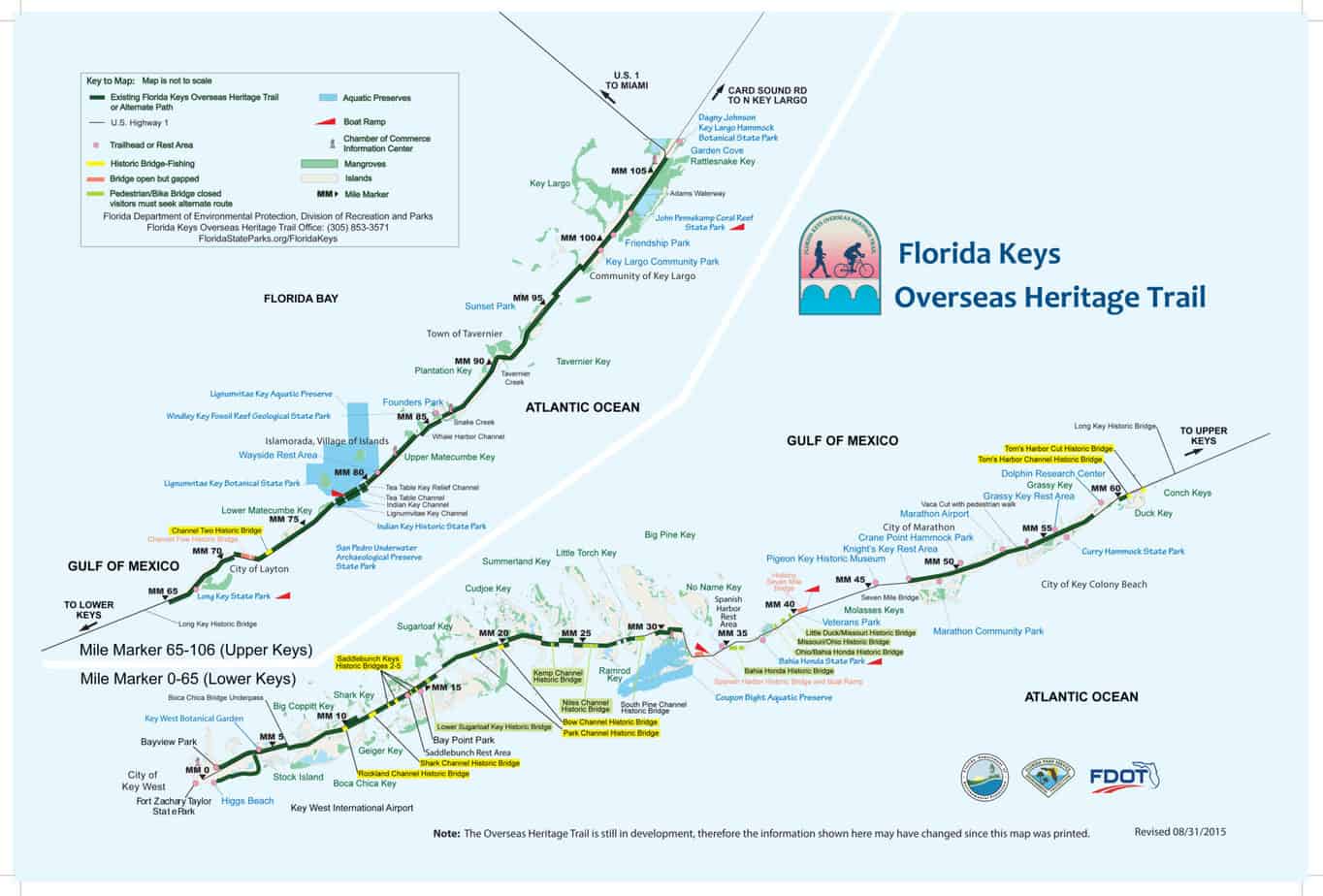
With more than 90 linear miles of existing trail in a planned 106-mile corridor, the Florida Keys Overseas Heritage Trail runs beside U.S. Highway 1 from Mile Marker 106.4 in Key Largo to Mile Marker 0 in Key West. It ties together neighborhoods, business districts, fishing bridges, and state parks. The route gives Monroe County a single corridor that locals use for recreation, commuting, and getting around the islands.
A corridor that tracks the Keys mile by mile
The trail functions as a recreational and alternative transportation corridor. People encounter it as a place to ride, walk, fish, or move between communities without staying on the highway the whole time.
The trail follows the shape of the island chain itself, which is why it works as a local guide to Monroe County geography. On some stretches, the path hugs the shoulder of U.S. 1. On others, it pulls users onto historic bridge spans that lift them over water and connect one key to the next.
Where the trail is strongest to ride
The longest continuous paved section is in the Upper Keys, from Mile Marker 106 at Key Largo through Mile Marker 72 at Islamorada. That stretch is especially useful for riders who want uninterrupted mileage without constantly weaving around gaps or bridge closures. It is also one of the easiest sections for visitors to understand because it closely follows the main spine of the Upper Keys.
The trail brochure gives Islamorada a 20-mile section. The route puts riders near some of the best-known side trips in the islands, including Windley Key Fossil Reef Geological State Park, Lignumvitae Key Botanical State Park, Indian Key Historic State Park, and the San Pedro Underwater Archaeological Preserve State Park.
Stops that matter in daily life, not just on vacation
In the Middle Keys and beyond, Long Key State Park is a bird-watching stop, giving the trail a built-in break point for people who want to slow down, look out over the water, and step off the bike for a while. Marathon serves as a central place to orient riders who need food, water, repairs, or a reset before moving south or north.
The trail is woven through places where residents already live, shop, and work. It is a usable alternative to driving the full length of U.S. 1, especially for shorter trips between neighborhoods, local businesses, and community facilities.
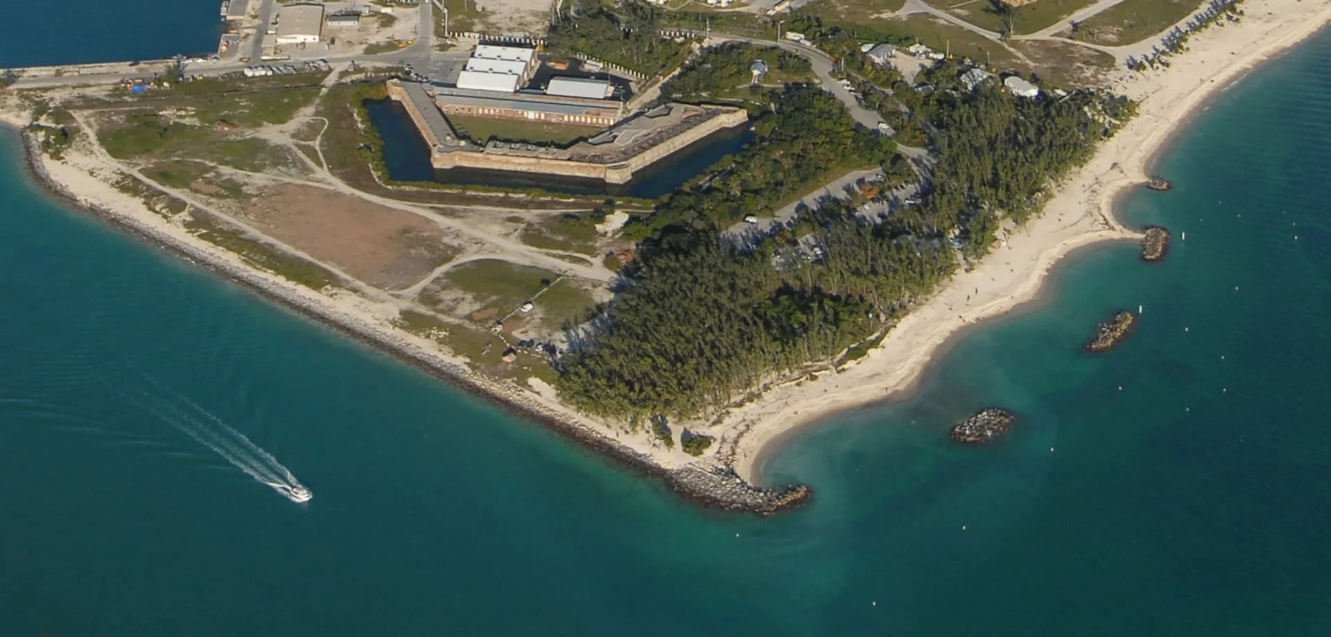
The bridges are the trail’s most distinctive landmarks
The corridor includes 23 historic Flagler Railroad bridges, and those spans are among the trail’s most memorable features. Henry Flagler built the railroad bridges in the early 1900s to connect the Keys to the mainland for the first time. Today, the same structures help define the trail’s character, especially where the route opens wide over open water.
The brochure highlights the historic Channel 2 and Channel 5 bridges as popular fishing spots. People stop there to cast a line, watch the water, or take in the long view down the island chain. Other bridge segments, including the Long Key historic bridge, Tom’s Harbor Cut bridge, and Tom’s Harbor Channel bridge, are also popular with anglers, hikers, bicyclists, and other trail users.
How to use the trail safely and legally
The trail is open 8 a.m. to sunset, 365 days a year, and no fee is required. Bicyclists, including e-bikes, may use trails designated for bicycle use in the state park system, consistent with Florida law.

Some stretches are still in development, and some bridge segments are closed or gapped, so alternate routes are sometimes necessary. Cyclists should use caution on the bridges, where wind, traffic patterns, and narrow crossings can change the feel of a ride quickly.
Why Monroe County treats it as infrastructure
Monroe County’s Planning & Environmental Resources department lists the Overseas Heritage Trail among its active projects. The county’s Engineering Services / Roads & Bridges department oversees pedestrian and bike paths and maintains the county’s roads, bridges, and bike paths.
The broader transportation system around U.S. 1 matters too. The Florida Department of Transportation’s KeysCOAST is a multimodal corridor management program on U.S. 1 in Monroe County designed to make the evacuation route future-ready. In the Keys, the same road carries commuters, shoppers, and visitors and serves the county during emergencies.
A trail built from history, preservation, and local vision
The trail grew out of a locally inspired vision and master plan. A task force formed in 1997 to preserve the bridges and open them for pedestrian and recreational use, and in August 2004 the remaining 20 historic railroad bridges and the Overseas Highway were listed in the National Register of Historic Places.
This article was produced by Prism’s automated news system from verified source data, official records, and press releases, then run through automated quality and moderation checks before publishing. The system is built and supervised by the people who set the standards it runs under. Read our full AI policy.
Did this article answer your question?