Late-April downpour floods Jacksonville streets, April rain tops normal levels
A late-April downpour flooded nearly every street in Jacksonville and South Jacksonville, pushing monthly rain well above normal and ending drought concerns for now.

Jacksonville’s late-April downpour did more than soak lawns. It overwhelmed storm sewers, sent water across at least parts of nearly every street in Jacksonville and South Jacksonville, and turned a wet month into a nuisance for drivers, homeowners and anyone trying to keep spring plans on schedule.
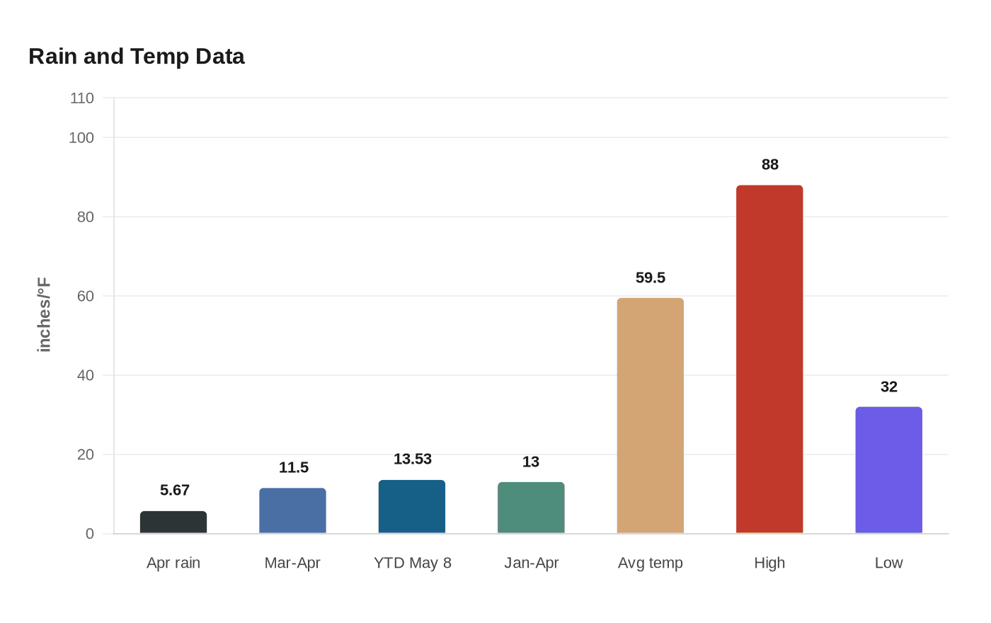
April finished with 5.67 inches of rain in Jacksonville, about 1.67 inches above normal, according to WLDS weather data. Measurable rain fell on 19 of the month’s 30 days, but the biggest punch came on April 28, when the single-day deluge was described as one of the biggest recent daily rain events in the area. By the end of March and April combined, the city had picked up nearly 11.5 inches of rain, a sharp jump after an early spring that had already moved conditions well past average.
That kind of runoff matters in Morgan County because it does not stay on the weather page for long. Streets flooded in Jacksonville and South Jacksonville, and the water raised familiar spring concerns about basements, parking lots and low-lying roadways. As of May 8, WLDS’ weather statistics page showed Jacksonville at 13.53 inches of precipitation for 2026, compared with 11.10 inches normally by that point in the year. The first four months totaled just under 13 inches, versus a normal 10 inches, a gap that leaves soil wetter, fields softer and drainage systems working harder heading into May.
The month was not just wetter than normal. It was also warmer. Jacksonville’s average temperature in April came in at 59.5 degrees, about 7 degrees above normal, with a high of 88 on April 15 and a low of 32 on April 20. That swing from near-summer warmth to a hard freeze in less than a week added another layer of stress for gardens, tender plants and outdoor schedules across Morgan County.
The April 28 flood also stood out because of how quickly it hit. WLDS compared it with the November 4-6, 2022 rain event, when more than 4 inches fell over three days instead of in one burst. That difference helped explain why the late-April storm caused street flooding even though the month’s total was only moderately above normal.
The outlook for spring had pointed the other way. A National Weather Service spring flood forecast issued March 5 said significant flooding was not likely anywhere in the region, and it put the Illinois River at a minor-flooding risk below normal. For now, the bigger concern in Jacksonville is not drought, but the next heavy rain and how quickly it can turn a routine spring storm into a problem for roads, yards and weekend plans.
This article was produced by Prism’s automated news system from verified source data, official records, and press releases, then run through automated quality and moderation checks before publishing. The system is built and supervised by the people who set the standards it runs under. Read our full AI policy.
Did this article answer your question?