Utqiagvik observatory tracks Arctic air at U.S. northernmost point
Utqiagvik’s Arctic observatory has tracked carbon dioxide since July 24, 1973, and its long records help residents read sea ice, snowmelt, and seasonal change.
At the edge of Utqiagvik, where the Arctic Ocean sits less than 3 kilometers away, NOAA’s Barrow Atmospheric Baseline Observatory has spent more than five decades measuring air that arrives from far beyond the North Slope. Established in 1973 about 8 kilometers east-northeast of town at 71.32°N, it is the longest continuously operating atmospheric observatory in the Arctic and a daily reminder that the world’s climate records are being built in a place where winter travel still happens by snow machine.
A North Slope asset, not just a science outpost
The observatory’s value in Utqiagvik starts with its setting. NOAA describes the site as part of an Arctic maritime climate shaped by the Beaufort Sea, open tundra, nearby lagoons, and a stream of prevailing east-northeast winds. That geography matters because the station sits upwind of human habitation, giving scientists access to a clean air sector that can sample air arriving from roughly 100 to 5,000 miles away.
That long reach makes the observatory useful well beyond atmospheric chemistry. The same measurements that help separate local pollution from regional and long-range signals also help explain why sea ice timing shifts, why snow melts earlier, and why summers are stretching longer along Alaska’s North Slope. For borough planners, school schedules, search-and-rescue planning, and the ordinary calculations families make about travel, hunting, and supply runs, that kind of long record is a practical tool, not an abstract archive.
What the site measures day after day
BRW supports more than 200 measurements, ranging from greenhouse gases and ozone-depleting chemicals to Arctic haze and stratospheric ozone depletion. NOAA also uses the site to track indicators tied to local change, including advancing snowmelt dates and longer summers, giving the community a scientific baseline for conditions that can affect land travel, coastal access, and the seasonal rhythm of work and school.
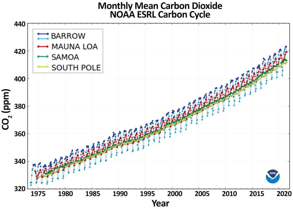
Some of the observatory’s most important records are the longest continuous Arctic datasets for atmospheric carbon dioxide, fluorocarbon trace gases, aerosols, surface and total column ozone, and solar radiation. Continuous CO2 measurements at the site began on July 24, 1973, and that uninterrupted record is one reason Utqiagvik holds such a central place in climate monitoring. The numbers do not just describe the atmosphere above the town; they show how the region is changing over time in a way that residents can compare against their own experience on the ground.
Keeping the record alive in a hard place
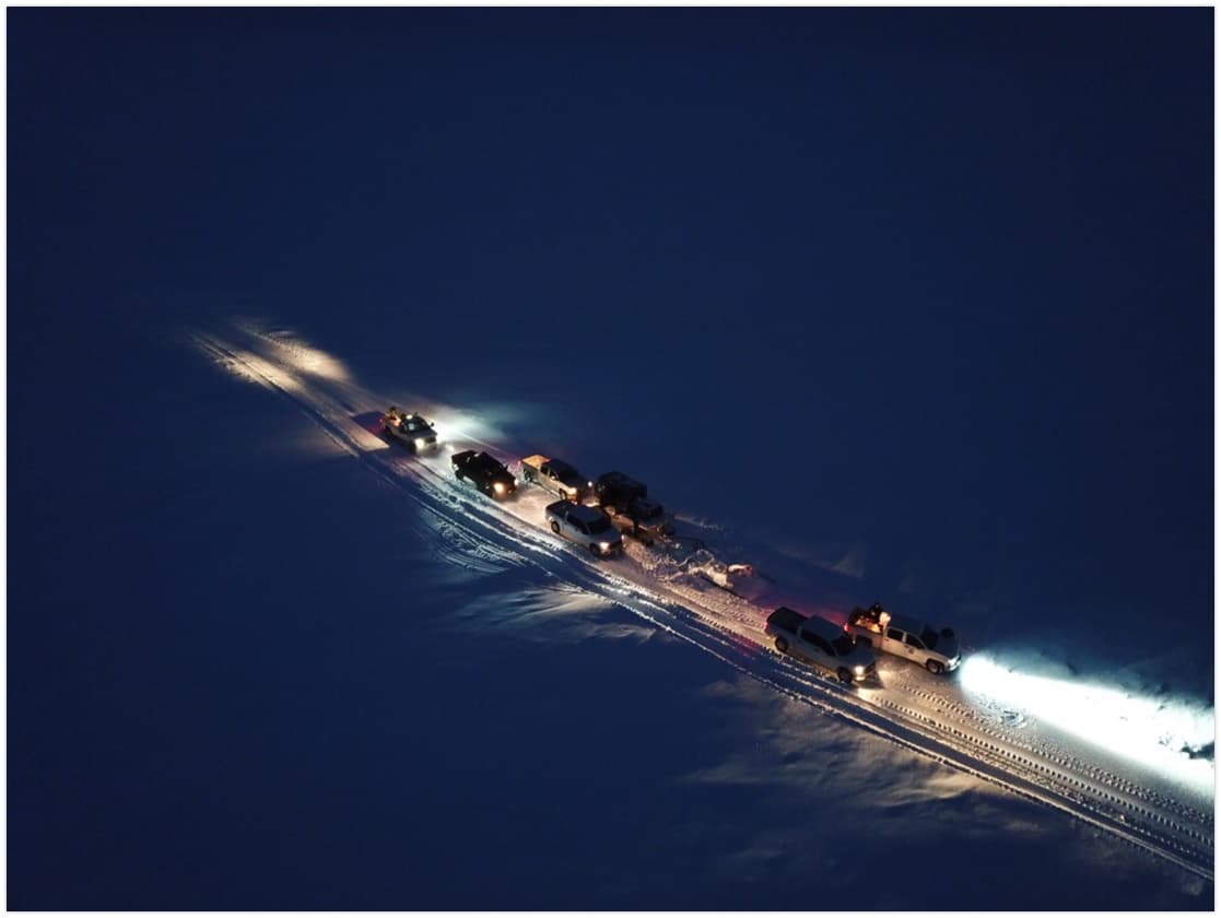
Long records do not happen automatically in the Arctic. NOAA says the observatory is staffed year-round by two engineers and scientists, and they often commute in winter on snow machines. That detail captures the reality of maintaining a national science asset in a place where weather, distance, and cold shape every movement.
For nearly half a century, those measurements were processed in a cramped 960-square-foot temporary structure. NOAA eventually replaced that building with a new 3,000-square-foot research facility that opened in 2020 and was dedicated in August 2022. The old lab, built for NOAA by the Navy as a temporary structure, was demolished in 2021 after almost 50 years of use.
The new facility gives the site room to work the way a modern observatory should. It includes a 30-meter instrument tower, a campaign science platform sized for two metal shipping containers, a dedicated computer server room, high-speed fiber to the contiguous U.S., and a permafrost temperature monitoring facility. Those upgrades matter in an isolated community because they improve the reliability of the data stream, make it easier to host visiting research teams, and keep the observatory tied into the broader scientific network even from the northern edge of Alaska.

Why this matters for daily life in Utqiagvik
The strongest local argument for the observatory is that it turns weather and climate into something measurable enough to plan around. In Utqiagvik, a shift in sea ice timing can affect when people travel and where they travel. Earlier snowmelt can change access to land routes. Longer summers can influence erosion, storage needs, and the timing of village and borough operations.
That is why the site belongs in the same conversation as North Slope Borough services, schools, and emergency response. A long, consistent climate record helps borough officials see whether a difficult year is part of a larger pattern. It also helps families compare what they are seeing now with what the atmosphere has been doing since the 1970s, when the first continuous CO2 measurements began.
The observatory’s location near the community also makes it a rare kind of public asset: one that is global in scope and local in consequence. When the station captures Arctic haze, ozone depletion, or shifts in solar radiation, it is contributing to international science. When it records a later freeze-up, an earlier melt, or a longer summer season, it helps explain the conditions that shape travel safety, food security, and the cost of moving through the North Slope landscape.
Part of a wider Arctic network
BRW is not an isolated outpost. NOAA says Barrow was the first research observatory in the Arctic and one of four baseline observatories in the NOAA Global Monitoring Laboratory network, alongside Mauna Loa in Hawaii, the South Pole in Antarctica, and American Samoa. That placement gives Utqiagvik a standing few places can claim: it is one of the points where the planet’s long-term atmospheric record is anchored.
The observatory also supports cooperative research projects from around the world, and that collaboration is part of its importance to the community. The work done at the site is tied to the International Arctic Systems for Observing the Atmosphere, the NOAA Arctic Program, the University of Alaska Fairbanks, the Barrow Arctic Science Consortium, the Arctic Slope Telephone Association Cooperative, the North Slope Borough, the U.S. Navy, and the U.S. Army Corps of Engineers, Alaska District. Those names reflect a larger reality in Utqiagvik: science here depends on local infrastructure, regional institutions, and the ability to keep operating in one of the most demanding environments on Earth.
A record built for the future
NOAA’s framing is blunt about the stakes. Climate change is happening faster in the Arctic than at lower latitudes, and the long records from BRW are essential for understanding changes in atmospheric composition, climate change, ozone depletion, and air quality. In Utqiagvik, that makes the observatory more than a place to collect data. It is a community landmark, a research engine, and a standing reminder that the North Slope is not only being studied from afar. It is helping define what the Arctic is becoming.
This article was produced by Prism’s automated news system from verified source data, official records, and press releases, then run through automated quality and moderation checks before publishing. The system is built and supervised by the people who set the standards it runs under. Read our full AI policy.
Did this article answer your question?