State of emergency declared as flooding and landslides hit Wellington region
Floodwater submerged cars near the Basin Reserve, closed roads and forced evacuations across Wellington as a state of emergency was declared.

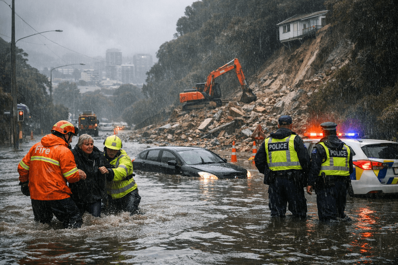
Floodwater turned streets near Wellington’s Basin Reserve into a hazard zone as torrential rain, slips and road closures spread across the capital’s southern suburbs and central city. By 4.30pm on Monday, 20 April 2026, Wellington City Council had declared a state of emergency for the Wellington region after overnight rain and flooding strained transport routes, homes and evacuation systems.
MetService had issued a red rain warning for Wellington, warning of dangerous river conditions, significant flooding and slips as a large, slow-moving low pressure system continued to push heavy rain across the lower North Island. Council updates said Island Bay, Berhampore, Newtown, Brooklyn, Mornington and the Basin Reserve area were among the worst-hit places, with two lanes around the Basin Reserve closed because of flood damage.
The disruption was visible across the city. Radio New Zealand reported submerged cars near the Basin Reserve, floodwater turning roads into what residents described as a river, and evacuations from Berhampore and Ohiro Road in Brooklyn. Wellington City Mission Whakamaru opened as shelter for evacuees, underscoring how emergency support quickly became part of the city’s response as homes, roads and movement corridors were knocked out by the rain.
In the wider region, the pressure spread beyond Wellington city limits. Lower Hutt Mayor Ken Laban urged people to check on neighbours after about 25 homes were evacuated in Stokes Valley, while deputy mayor Keri Brown warned residents to leave without waiting for an official alert if water began rising. Radio New Zealand later reported that 26 homes in Stokes Valley and Porirua were evacuated and that multiple state highways were closed, adding to the strain on travel and emergency access across the region.
The state of emergency gave responders extra powers and coordination to support evacuations and keep people safe. The National Emergency Management Agency says that such a declaration provides controllers and others with extraordinary powers for a swift response, a sign of how quickly a severe weather event can overwhelm local systems when dense neighbourhoods, steep slopes and flood-prone roads are all exposed at once.
The latest flooding followed other severe weather impacts in recent months, and local officials have pointed to repeated flooding in vulnerable areas in recent years. With more rain forecast into Tuesday night, the crisis raised a harder question for Wellington: whether transport routes, housing on unstable ground and emergency planning are keeping pace with a climate pattern that is already delivering more frequent and more damaging extremes.
This article was produced by Prism’s automated news system from verified source data, official records, and press releases, then run through automated quality and moderation checks before publishing. The system is built and supervised by the people who set the standards it runs under. Read our full AI policy.
Did this article answer your question?


